Symetri Launches Naviate Zero, Advancing Sustainable Building Design with Innovative Green Technology
Addresses the urgent need for enhanced sustainable practices, reduced embodied carbon and CO2 emissions in the AECO and manufacturing industries Nashua, NH – Symetri, part of Addnode Group, and a leading global provider of design and engineering technology solutions and consultancy services, announces the launch of Naviate Zero a specialized solution to enhance sustainability and energy efficiency for the architecture, engineering, construction, owner (AECO) and manufacturing industries....

Bridge protection and traffic safety at its finest
The Great Belt Bridge in Denmark, one of the world’s longest suspension bridges, benefits from Structural Health Monitoring thanks to measurement technology by Kistler Kistler presents unique Structural Health Monitoring and Weigh In Motion portfolio at Intertraffic 2024 Winterthur, February 2024 The next stop for condition monitoring of sensitive infrastructure: the Kistler Group is showcasing its latest solution for bridge protection and traffic safety, a comprehensive Structural H...
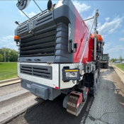
Trimble Introduces Roadworks Paving Control Platform for Mills and Cold Planers
New version of Trimble’s next-generation paving control platform for smoother, more precise paving surfaces extends the functionality to an additional machine type WESTMINSTER, Colo., February 20, 2024 — Trimble (NASDAQ: TRMB) announced today the availability of the Trimble® Roadworks Paving Control Platform for Mills and Cold Planers, extending the functionality of Trimble’s next-generation, 3D paving control system. Trimble Roadworks for Mills and Cold Planers runs on an Android™ opera...
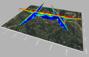
Latest Surfer® Mapping and 3D Visualization Package from Golden Software Gives Users Comprehensive View of Subsurface Data
Import imagery, such as PNG files of geophysical profiles, and position the images in any orientation! Import any georeferenced images, such as an aerial image in GeoTIFF format, and it is placed directly in the correct location. GOLDEN, Colorado, 13 February 2024 – Golden Software has further enhanced the 3D visualization capabilities of its Surfer mapping and 3D visualization software to give users a complete picture of their subsurface data. The expanded visualization tools in the lat...

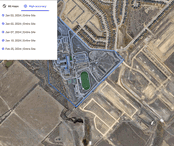
Esri Releases New Landsat Satellite Data App to View and Analyze Land Changes
andsat Explorer Makes Longest-Running Continuous Satellite Imagery More Accessible for Decision-Makers REDLANDS, Calif.—February 13, 2024—Esri, the global leader in mapping and location intelligence, announces the launch of Landsat Explorer, a groundbreaking online app that makes it easier than ever for organizations to access and analyze multispectral imagery from Landsat satellite missions. Remote sensing and earth observation imagery play a crucial role in helping organizations at local, r...
Trimble and DroneDeploy Introduce Premier Positioning Accuracy and Streamlined Workflow for Reality Capture from Drones
RTX-based cloud positioning service expands project opportunities for drone mapping DENVER – GEO WEEK (Booth# 1001) – Trimble (NASDAQ: TRMB) announced today the integration of the Trimble Applanix POSPac CloudⓇ post-processed kinematic (PPK) GNSS positioning service, featuring CenterPointⓇ RTX, with the drone mapping and data collection capabilities of DroneDeploy’s reality capture platform. With the Trimble cloud positioning service, DroneDeploy customers can expect centimeter-level acc...

DJI Launches Its First Intelligent 3D Model Editing Software DJI Modify
Makes repairing common 3D model defects simple and efficient January 18, 2024 – DJI, the world’s leader in civil drones and creative camera technology, today introduced DJI Modify, the company’s first intelligent 3D model editing software. This complementary solution pairs seamlessly with DJI’s enterprise drones and 3D modeling and mapping software, DJI Terra, forming a comprehensive solution for aerial surveying, modeling, and model editing, to meet the operational needs for surveying,...

Trimble Introduces MX90 Mobile Mapping System
Trimble announced today the leading-edge Trimble® MX90 mobile mapping system. With state-of-the-art Trimble GNSS and inertial technology, when combined with Trimble field and office software, the Trimble MX90 provides a complete field-to-finish mobile mapping solution that enables powerful workflows for data capture, processing and analysis. Richer Data for Large-Scale Scanning & Mobile Mapping Projects The vehicle- or train-mounted MX90 rapidly captures highly detailed laser scans an...
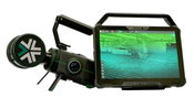
Exyn Unveils Nexys: A Fully Modular 3D Mapping Solution for Complex and Challenging Environments
GEOWEEK, FEBRUARY – Exyn Technologies, a pioneer in autonomous robotics, today announced the launch of Exyn Nexys, a revolutionary modular 3D mapping solution. Designed for professionals in mining, construction, AEC, and geospatial industries, Nexys sets a new standard in autonomous mapping technology, offering unparalleled flexibility, speed, and accuracy in the most demanding surveying and inspection environments. Unmatched Modularity for Every Mapping Scenario Nexys’ groundbreaking modu...

A New Standard for Material Testers: 'Connected CMT Machines' Promise Speed, Accuracy
Does your machine 'know' what it's testing? Forney introduces Connected controls to renowned fleet of construction materials testing machines. ZELIENOPLE, Pa., February 6, 2024-- Forney LP, the leading manufacturer of construction materials testing (CMT) machines, equipment and software, recently launched a new type of machine that eliminates the possibility of specimen misidentification at the machine. Using a Forney Connected Machine, a technician can load and test a specimen twice as fast...
Video: Crashes Drop Measurably After Rural Road Safety Improvement Project on US 521 in Lancaster County

AdventHealth Weaverville Hospital

June Issue 2026
.jpg?width=225)