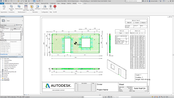
Announcing Autodesk Structural Precast Extension for Revit 2018
Autodesk brings into play a new automated workflow for the precast concrete industry. The Autodesk Structural Precast Extension for Revit 2018 is a BIM-centric offering for modeling and detailing precast elements that promotes productivity and precision for engineers, detailers and fabricators working on typical building projects in the precast industry. As an app for Autodesk Revit software, Structural Precast for Revit provides Revit users access to powerful tools for automatic rule-based segm...
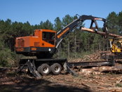
Barko “B” Series Merchandising Loaders Deliver Service and Safety Enhancements
SUPERIOR, Wisc. – Barko’s B-Series merchandising loader product line has been updated to offer several new service and safety features. Known for rugged components and durable construction to withstand the rigors of forestry jobs, the loaders deliver high-capacity performance for various log handling applications, including sorting, stacking, pull-through delimbing and loading. New enhancements to provide easier and safer machine serviceability on the B-Series loaders include relocated f...
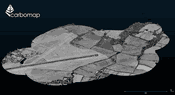
Carbomap Ready to Map the World with Advanced LiDAR on High Performance UAV
EDINBURGH / UNITED KINGDOM – Carbomap, an environmental survey company, in collaboration with high performance LiDAR manufacturer RIEGL, UAVE and The University of Edinburgh, today announced the first successful demonstration flight of a RIEGL VUX-1LR survey-grade waveform laser scanner on a fixed wing, long range unmanned aerial vehicle (UAV). This is likely the first time that such a high-performance scanner has ever flown on a fixed wing UAV with such an advanced specification for long durati...

Changing the Methods of Design and Delivery: HDR Releases Book on Data-Driven Design
HDR’s newest publication, “Data-Driven Design,” is now available. Developed to describe an emerging methodology at the organization, the book illuminates the consulting group’s computational design process and how it connects the built environment with predictive analytics and operational design. The 60-page book explains how HDR is uniting its consulting services with the design process by leveraging strategy, research and analytics. The book also offers concrete project examples. “Bringi...

New App to Quantify Sustainability of Coil Coatings
Berlin/Germany – Beckers Group, leading worldwide supplier of coil coatings, just launched a tool to quantify the sustainability of its coating products. The Beckers SI app is designed for architects, designers, building planners and steel makers: individuals or companies who are involved in the planning or construction of a building and aim to work with green materials without compromising on the design. For different applications such as roofing or façade systems, the Beckers SI app shows u...
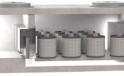
PerkFilter System Receives NJCAT Verification and NJDEP Certification for Stormwater Treatment
LITTLETON, Colo. (JULY, 2017) – The performance of the PerkFilter™ media filtration system for stormwater treatment has been verified by the New Jersey Corporation for Advanced Technology (NJCAT), one of the most comprehensive, rigorous and recognized verification programs in the country. Additionally, the PerkFilter system has been certified by the New Jersey Department of Environmental Protection (NJDEP) as an approved stormwater treatment device based on the NJCAT verification. The revolut...
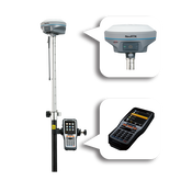
Tersus Launches the NeoRTK System to Unleash Surveying Potential
Tersus GNSS Inc. (“Tersus”), a leading GNSS manufacturing company announces its launch of a new generation GNSS RTK system with multi technology integrated for surveyors, the NeoRTK System. NeoRTK System is a high-performing GNSS RTK system applied with multi-constellation and multi-frequency GNSS engine and various communication protocols which aim at providing high performance and stable signal reception satisfying surveyors’ demands. With high-end GNSS antenna inside, NeoRTK can speed up...
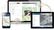
Structural Integrity Chooses TerraGo Magic to Build Customized Field Data Collection App
TerraGo announced today that Structural Integrity, a global leader in engineering services and solutions for structural evaluation and repair, chose TerraGo Magic to build a field data collection and collaboration app for field inspectors, engineers and other personnel to improve the efficiency of inspection workflows, field reporting and data management. “When dig sites are identified, for example from an in-line inspection tool indicating a pipe requires further inspection, inspectors can i...
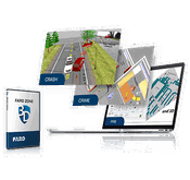
FARO Releases Revolutionary FARO Zone 3D for Public Safety Professionals
Lake Mary, FL - FARO® (NASDAQ:FARO), the world’s most trusted source for 3D measurement and imaging solutions for factory metrology, construction BIM/CIM, product design, public safety forensics, and 3D solutions applications, announces the availability of the FARO Zone 3D software. This revolutionary platform, through its advanced smart tools, is the first of its kind to enable investigators to move fluidly between 2D and 3D environments and enhance the quality of incident reconstruction analys...
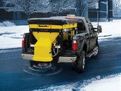
SnowEx Introduces New V-Maxx G2 Hopper Spreaders With Enhanced Controls and Spreading Performance
MADISON HEIGHTS, Mich. – Equipped with updated controls and enhanced material spreading features, the new SnowEx® V-Maxx™ G2 hopper spreaders offer greater performance and operating efficiency for contractors and municipalities on large ice control applications. A new dual variable-speed control is more compact than on previous models. This digital, self-diagnosing unit allows independent adjustment of spinner and auger speeds, while convenient buttons offer easy control of the standard...
Video: New Roundabout Under Construction at McIver and Old Florence Roads in Darlington County

Promenade at The Point

June Issue 2026
.jpg?width=225)