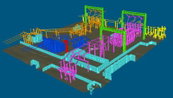
VRMesh V11.2 Adds Two-Sided Meshing for Visualizing Large-Volume Scans
Seattle, WA – VirtualGrid announced today the release of VRMesh v11.2, the latest version of its powerful point cloud and mesh processing software. This release presents a new method of point cloud meshing that enables users to convert point clouds to a two-sided mesh for visualizing intricate environments such as construction sites.As a technology pioneer in the field of point cloud meshing, VRMesh has been famous for creating an accurate mesh to represent original objects with high details. To...

Gexcel announces RECONSTRUCTOR 4.2
Reconstructor 4.2 increases the capability to manage data from tunnels, underground and open-pit mines 3D surveys, thanks to new and improved tools that help users get the result done by a smart process. Gexcel has announced the release of Reconstructor that introduces some very interesting improvements for mining, tunneling, construction, and infrastructure applications thanks to new strategic workflows designed to easily guide customers to final deliverables from the surve...
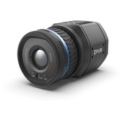
FLIR Launches its First Uncooled, Fixed-Mount, Connected Thermal Camera for Detecting Methane: GF77a
FLIR GF77a Offers Low-Cost Optical Gas Imaging Solution for Continuous and Autonomous Leak Detection ARLINGTON, Va.– FLIR Systems, Inc. (NASDAQ: FLIR) announced today the FLIR GF77a Gas Find IR camera, its first fixed-mount, uncooled, autonomous leak detection camera designed specifically to visualize methane and other industrial gases. A new camera in FLIR Systems’ optical gas imaging (OGI) series, the connected GF77a provides upstream and midstream gas processors, producers, and operators w...
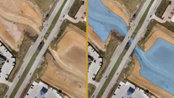
Virtual Surveyor Streamlines Volumetric Calculations for Stormwater Retention Ponds, Basins & Quarries
AARSCHOT, Belgium – Virtual Surveyor has released Version 7.1 of its popular drone surveying software, introducing functionality to efficiently calculate volumetrics in quarries, mine pits, retention ponds, and other basins that fill with water. This new functionality complements advanced cut-and-fill mapping capabilities unveiled in late 2019. “Virtual Surveyor is now the go-to package for managers of mines, drainage pits, and stormwater retention basins,” said Tom Op ‘t Eyndt, CEO of Virtua...

SimActive Speeds Up Stockpile Measurement with Drones
Montreal, Canada – SimActive Inc., a world-leading developer of photogrammetry software, announces an enhanced workflow in Correlator3D™ to accelerate stockpile measurement. The new capability allows to automatically assess multiple volumes within the same project and output comprehensive reports. If the same area is regularly flown, the new workflow also allows to easily compare volumetric values to assess differences in time. In addition, change detection can be performed to precisely qua...

KOREC and NCTech launch KlearView360°
Companies join forces on vehicle-based visual asset inspection and verification system Liverpool & Edinburgh, UK – KOREC and NCTech today announced the launch of KlearView360°, a streamlined, hosted system designed for the identification of assets, defects or changes within images collected by vehicle or backpack. A cost-effective solution, KlearView360° makes vehicle-mounted asset inspection accessible to local authorities and many others. The system is a joint partnership between the tw...
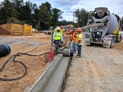
Curb Roller Manufacturing Cuts Curb and Gutter Work in Half with the Curb Roller CM4000
FAIRVIEW, Kan. – Curb Roller Manufacturing, the world leader in shaped concrete roller screeds, offers the Curb Roller CM4000, a single-operator machine for shaping concrete for curb and gutter work. The CM4000 reduces the labor of shaping curb and gutter pours, allowing crews to complete work up to twice as fast as manual methods or face forming. The Curb Roller CM4000 is most commonly used for curb and gutter projects ranging from 50 to 5,000 linear feet, and can be used on jobs of all typ...

Enscape Introduces Version 2.7 of its Real-Time Rendering Software
New BIM-driven Workflows and Enhanced Performance Make Enscape the Perfect Complement to the Building Design Process Karlsruhe, Germany — Enscape, the leading provider of real-time rendering and visualization technology to the global Architectural, Engineering, and Construction (AEC) market, announces the version of Enscape 2.7. This newest version brings improved performance, quality enhancements, and new BIM-driven workflows. “Enhancing BIM workflows and improving usability are the majo...

Leica Geosystems announces new most accurate total station
Leica Nova TS60 minimises costs and downtime with sub-second and sub-millimetre accuracy, newly integrated DynamicLock and AutoHeight features. Heerbrugg, Switzerland – Leica Geosystems, part of Hexagon, announced today the new Leica Nova TS60, the world’s most accurate total station, with newly integrated DynamicLock and AutoHeight features. The new version of theTS60 total station is now equipped with DynamicLock, allowing the instrument to lock onto a moving prism, and devised with...

Leica Geosystems Brings the World’s First MultiStation to the Next Level
The new version of Leica Nova MS60 enables users to perform all surveying tasks with one instrument (Heerbrugg, Switzerland, 18 February 2020) – Leica Geosystems, part of Hexagon, announced today the new Leica Nova MS60. The MS60 MultiStation, brings sensor fusion to the next level by combining upgraded faster 3D laser scanning capabilities, GNSS connectivity and digital imaging with a highest-end total station. The new MS60 features several laser scanning updates, including an incredib...
Video: Crashes Drop Measurably After Rural Road Safety Improvement Project on US 521 in Lancaster County

AdventHealth Weaverville Hospital

June Issue 2026
.jpg?width=225)