
Get to Know AutoCAD 2022 – The Connected Design Experience
AutoCAD 2022 drives design forward with connected workflows and automations that let you focus on what matters most: creating great designs. Packed full of value, AutoCAD including specialized toolsets offers CAD software that is trusted by millions, provides access to seven industry-specific toolsets with automations to speed work, includes the AutoCAD web and mobile apps to access the power of AutoCAD anytime, anywhere, and includes cutting-edge new features. Transforming how you work, n...

Bentley Acceleration Initiatives Launches OpenTower iQ, a Digital Co-venture with Visual Intelligence and Aeroprotechnik for 5G Towers
Conduct automated inventory including automated AI for equipment identification and classification. Millimeter-accurate Digital Twin Solution Combines Patented Dual-sensor Drone Technologies and Artificial Intelligence to Help Tower Companies Accelerate Rollouts and Enhance Decision-making EXTON, Pa. – March 23, 2021 – Bentley Acceleration Initiatives today announced the availability of OpenTower® iQ, a digital twin solution “powered by iTwin” for telecom towers that provides 3D...

EagleView and Esri Canada Announce New Integration Within Cityworks Platform
New integration will make it easier than ever for Cityworks users in Canada to access EagleView's high-resolution aerial imagery BELLEVUE, Wash. and TORONTO, Canada, March 23, 2021 - EagleView, a leading technology provider of aerial imagery and data analytics, and Esri Canada, a leading provider of geographic information system (GIS) solutions and sole distributor of Cityworks public asset management solutions in Canada, today announced a new integration to simplify the asset management work...
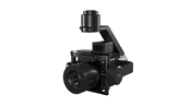
Phase One Announces P3 Drone Payload for Asset Inspection
COPENHAGEN – Phase One, a leading developer of digital imaging technologies, today announced the P3 Payload, a versatile solution designed for fast, efficient, and safe inspection of critical infrastructure with an Unmanned Aerial Vehicle (UAV). The P3 Payload includes a Phase One iXM 100MP or 50MP camera, one of the RSM lens options, and a new gimbal with integrated rangefinder. Available in Q2 2021, the P3 Payload is extremely versatile, offered in two configurations to meet a wide range of...

Pinnacle Introduces Next Evolution of Reliability Modeling
Proving out new methodology estimated to reduce facilities’ reliability spending by 10% to 30% PASADENA, TEXAS – Pinnacle, the world’s leading provider of data-driven reliability and integrity programs, today introduces an improved approach to reliability modeling, called Quantitative Reliability Optimization (QRO). This new approach streamlines current reliability methodologies into a single, comprehensive analysis, empowering leaders in processing industries to make smarter decisions at a...

Trimble Announces Release of Tekla 2021 Structural BIM Software Solutions
New Versions Deliver Enhanced Usability, Data-Driven Workflows and Real-Time Collaboration SUNNYVALE, Calif. —Trimble (NASDAQ: TRMB) introduced today the latest versions of its Tekla® software solutions for constructible Building Information Modeling (BIM), structural engineering and steel fabrication management—Tekla Structures 2021, Tekla Structural Designer 2021, Tekla Tedds 2021 and Tekla PowerFab 2021. New Tekla software features and enhancements continue to power data-driven, collabora...

Leica Geosystems Announces BLK3D Update
Leica BLK3D - the in-picture measurement solution (HEERBRUGG, SWITZERLAND, 18 March 2021) – Leica Geosystems, part of Hexagon, today announced the Leica BLK3D update. The new handheld imager has doubled its operating range and in-picture measurement accuracy for many indoor and outdoor applications, such as exterior building measurements for scaffolding, façade, roofing, and architecture projects. The BLK3D users can capture façades of four-storey buildings with centimetre accuracy in sec...

FARO® Introduces BuildIT 2021 Software Suite
Simplifies Workflows & Enhances Ease for Manufacturing, Assembly & Construction LAKE MARY, FL, March 18, 2021 – FARO Technologies, Inc. (Nasdaq: FARO), a global leader for 3D measurement, imaging and realization solutions, today announced the release of its most advanced BuildIT 2021 software suite, which represents the next evolution of this platform that simplifies workflows, improves performance and enhances ease of use. BuildIT offers three individual products – BuildIT Metrology, Buil...

Vectorworks, Inc. Announces Unreal Engine Partnership and Service Pack 3 Release
Major updates include a new real-time rendering connection to Twinmotion and Unreal Engine, a direct connection with Solibri plus a new Vectorworks Cloud Services folder sharing feature for project teams Columbia, MD (March 16, 2021)—Global design and BIM software provider Vectorworks, Inc. has released its third service pack for the Vectorworks 2021 product line focusing on key updates for their architecture, landscape architecture and entertainment design customers. Notable highlights...

New Leica CityMapper-2L configuration enables digital twin creation of cities in complex weather and congested flight operation areas
With a new focal length combination for ultra-high resolution projects or operations when low flying altitude is required, the Leica CityMapper-2 now offers a full product portfolio covering all flying parameters and GSD’s (HEERBRUGG, SWITZERLAND) – Leica Geosystems, part of Hexagon, introduces the new Leica CityMapper-2L configuration specifically designed for airborne urban mapping projects at low altitude operation. Lower flying heights can be required by air traffic control (ATC) restrict...
Video: Crashes Drop Measurably After Rural Road Safety Improvement Project on US 521 in Lancaster County

AdventHealth Weaverville Hospital

June Issue 2026
.jpg?width=225)