
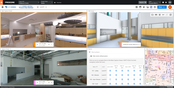
New Critigen Lemur Release Extends Enterprise Mobile GIS Capabilities
Intuitive Critigen solution delivers enhanced data synchronization, scalability, and security for tens of thousands of field workers DENVER - Critigen today announced the latest release of Lemur, its mobile GIS solution. Lemur delivers enterprise mapping capabilities that complement field service apps used in utilities, oil and gas, transportation, local and federal government, and other large organizations. The latest release provides expanded support for the enterprise, with enhancem...

Hexagon revolutionises autonomous reality capture with the launch of the Leica BLK ARC and Leica BLK2FLY
NACKA STRAND, Sweden - Hexagon AB, a global leader in digital reality solutions, today announced the introduction of the Leica BLK ARC and the Leica BLK2FLY, extending its iconic and award-winning BLK series known for speed, portability and mobility with fully autonomous mobile reality capture. The autonomous reality capture solutions are the latest innovations in Hexagon's comprehensive portfolio of accessible, easy-to-use digital reality capture sensors. The Leica BLK ARC is a laser scannin...
Cupix Integration with Procore Delivers Industry’s First Location-Based Virtual Job Site Navigation
Integration with CupixWorks 3D Digital Twin Platform Works Seamlessly within the Procore Platform with No Additional Training Required SAN JOSE, CA - Cupix, the fast-growing pioneer of cutting-edge 3D digital twin solutions for building owners and the architecture, engineering and construction (AEC) industries, today announced the expanded integration of its CupixWorks 3D digital twin platform with Procore Technologies, Inc., a leading provider of construction management software. Un...
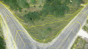
Virtual Surveyor Improves Point Cloud Workflow to Fully Leverage Drone LiDAR Payloads
Contour lines at bare earth from Zenmuse L1 data AARSCHOT, Belgium – Virtual Surveyor has developed an enhanced point cloud workflow for Version 8.3 of its drone surveying software that allows users to take full advantage of the new LiDAR payloads like the DJI Zenmuse L1. LiDAR drone sensor systems enable users to capture survey-grade elevation data even in vegetated terrain. “The powerful DJI Zenmuse L1 system is especially receiving fast adoption by drone users in construction, engi...
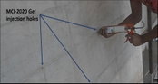
MCI®-2020 Gel Delivers Robust Corrosion Protection to the Depth of Steel Reinforcement
Corrosion of metal reinforcement is one of the most serious threats to the durability of concrete structures. While many excellent technologies delay and mitigate the effects of corrosion on embedded reinforcement, there are fewer options when corrosion takes place deep inside concrete. Is such difficult-to-access corrosion beyond the reach of existing treatments? Cortec® Corporation answers that question with a resounding “no!” in the form of MCI®-2020 Gel, designed to penetrate to the heart of...
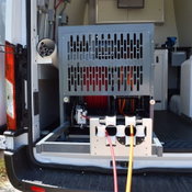
Aries Industries Introduces New Dual Reel for Sewer Mainline and Lateral Inspection
Compact, dual reel offers improved performance, maximization of truck space Waukesha, Wis. – Aries Industries, the industry leader in state-of-the-art equipment for inspection and maintenance of underground infrastructure, has introduced a new dual reel for the company’s sewer mainline and lateral evaluation system. Moving from a stacked to a combined configuration, the new reel occupies a slim footprint within Aries Industries inspection vehicles. Sliprings are now inside the shaft,...
BIMrx™ 3.0 Offers a More Intuitive UI and Powerful Modeling Features with Automation of Common Tasks through BIMrx Integration with Cloud Manager™
Nashua, NH - Global BIM and EAM consulting firm Microdesk, a leading provider of business and technology services for the design and construction industry, has released version 3.0 of the BIMrx™ software suite for BIM project lifecycle automation. Enhancements to each product include intuitive UI updates, expanded export options and cloud integrations. Version 3.0 of BIMrx™ further streamlines the tasks associated with Revit project setup, modeling and project management, allowing AEC profession...

Prospect by IrisVR Creates End-to-End Coordination for BIM Teams with New Immersive Issue Tracking Feature
Portland, OR – Today, VR/AR collaboration platforms IrisVR and The Wild announced their official support for immersive end-to-end issue tracking in IrisVR‘s flagship product, Prospect. This product update allows for a full-cycle coordination workflow for building teams working with 3D models such as Revit and Navisworks. This will be the product’s first release in 2021. The Wild acquired Prospect by IrisVR in February of 2021 and has been in deep development of this critical feature to ensure...

Spacewell Releases Opportunity Simulator for Offices
New analytical dashboard dynamically simulates space optimization scenarios and calculates space savings Supports CRE and workplace leaders to leverage the massive opportunity to optimize the office footprint and configuration (mix of workstations/collaboration spaces/concentration spaces) post-Covid Antwerp, August 23, 2021 – Spacewell, a global provider of building and workplace software and technology solutions, today launched its new Opportunity Simulator dashboard for the post-pand...

Simpson Strong-Tie Adds Three 2x Sizes for Field-Adjustable LSSR Rafter Hangers
Pleasanton, Calif. — Simpson Strong-Tie, the leader in engineered structural connectors and building solutions, now offers its versatile, patent-pending LSSR rafter hanger in 2x lumber sizes that can install with both miter-cut and square-cut joists for plated truss. The three new models — LSSR26Z, LSSR28Z and LSSR210Z — feature a ZMAX® finish for extra corrosion protection and respectively accommodate 2x6, 2x8 and 2x10 lumber. Like the original LSSR models, these new sizes are field-adj...
Video: Crashes Drop Measurably After Rural Road Safety Improvement Project on US 521 in Lancaster County

AdventHealth Weaverville Hospital

June Issue 2026
.jpg?width=225)