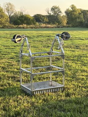
LineWise Introduces Line Cart for Use on Single Static Lines
WACO, Texas — LineWise has introduced a Line Cart designed for use on single static lines. Featuring a 300-pound capacity, the new product is designed to provide a safe mobile platform when performing line inspection, installing marker balls or bird diverters, and other regular maintenance tasks on transmission lines. The only product of its kind on the market, the Line Cart provides an excellent alternative to bucket trucks, which are inefficient because of the need for constant repositionin...

Montana Department of Transportation Transitions to Autodesk Infrastructure Design Solutions Partnering with U.S. CAD for Deployment and Implementation
Adopting Autodesk’s Best-in-class Solutions Paired with U.S. CAD’s Expert Guidance for Professional Services is a Key Part of State’s Digital Delivery Initiative IRVINE, Calif. – U.S. CAD, a leading AEC technology and consulting firm, and Autodesk Platinum Partner, today announced it will provide deployment and implementation services as part of the Montana Department of Transportation’s (MDT) move to Autodesk AEC Collection® for its employees focused on highway and bridge design. The dec...
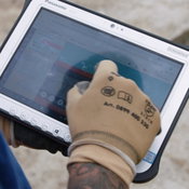
Panasonic TOUGHBOOK Supports Swiss Engineering Company in Move to Paperless Construction Site
KIBAG’s construction workers’ capabilities are transformed with Panasonic Business solutions. BRACKNELL, UK. 26th October 2021 – KIBAG, a Swiss civil engineering company, is taking the final step towards a paperless construction site with the adoption of TOUGHBOOK G2 tablets. All workers and contractors can now access digital construction plans using the rugged tablet. The use of the devices shortens execution times and minimises construction errors. The deployment allows KIBAG employ...

New Integration for Hovermap Data in PointCab Origins Streamlines Point Cloud to Output
A new Emesent - PointCab Origins integration will save users time and improve their outputs. Hovermap, Emesent’s flagship product, is an autonomy and mapping payload capable of capturing high resolution LiDAR data above ground or underground, indoors or out. Hovermap’s proven autonomy functions allow it to fly supported drones, like the DJI M210, DJI M300, or Acecore Zoe, beyond line of sight and communication range. PointCab Origins is a 3D data visualization, manipulation, and men...

Hexagon Releases Power Portfolio 2022
Latest version empowers users with automated workflows and improved information sharing (HUNTSVILLE, Ala.) – Hexagon’s Safety, Infrastructure & Geospatial division today announced the launch of Power Portfolio 2022, the latest version of its leading GIS, remote sensing, photogrammetry and geospatial data management products. The Power Portfolio helps organizations collect, process, analyze and understand geospatial data and organize it into centralized libraries for easy sharing through...
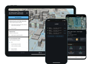
Skyward Integrates Updated LAANC for Night Airspace Access & Refined Grids
Latest generation of FAA’s LAANC introduces authorizations for drone flights at night and refined airspace grids for Skyward customers PORTLAND, Ore. – Skyward, A Verizon company, announced that the next generation of the FAA’s Low Altitude Authorization and Notification Capability (LAANC) is now live within the Skyward platform. The latest update introduces authorization requests for nighttime drone flights in controlled airspace, as well as refined airspace grids. Skyward cus...
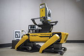
Trimble Releases Turnkey Autonomous Robotic Scanning Solution
Boston Dynamics' Spot Robot Fully Integrated with the Trimble X7 3D Laser Scanner and Trimble FieldLink Software Now Available as a Complete Solution from Trimble SUNNYVALE, Calif., Oct. 19 2021 - Trimble (NASDAQ: TRMB) announced today the release of the Trimble® X7 3D laser scanner and Trimble FieldLink software fully integrated with Boston Dynamics' Spot® robot. This exclusive turnkey solution from Trimble, jointly developed with Boston Dynamics, facilitates autonomous operation on construc...
Xylem Showcases New Wastewater and Water Filtration Products and its Digital Solutions at WEFTEC 2021
Partnerships key to advancing the industry in extraordinary times CHICAGO – With continued efforts to create a more water-secure and sustainable world, global water technology leader Xylem (NYSE: XYL) is inviting attendees of the 2021 Water Environment Federation’s Annual Technical Exhibition and Conference (WEFTEC) to visit Booth 1808 and learn how Extraordinary Times Call for Extraordinary Partnerships. As the industry evolves, partnerships are becoming increasingly crucial to the opt...
EagleView and Cityworks Announce New Integration Now Available in the US
Customers in both the US and Canada can now easily access EagleView’s high-resolution aerial imagery from the Cityworks Esri map viewer BELLEVUE, Wash., and SANDY, Utah – EagleView, a leading technology provider of aerial imagery and data analytics, and Cityworks, a Trimble Company, today announced the US availability of an integration to simplify the asset management workflow. For the first time, users in the US as well as Canada can launch EagleView’s Integrated Pictometry Application (IPA)...
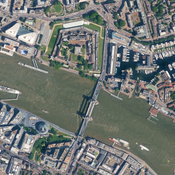
Hexagon Adds England, Scotland and Wales to the HxGN Content Program
12.5-centimeter resolution aerial imagery of the Tower Bridge in London, England (Heerbrugg, Switzerland, 14 October 2021) Hexagon's Geosystems division announced today that the HxGN Content Program now offers aerial imagery of England, Scotland and Wales at up to 12.5-centimetre resolution through its partnership with Bluesky International Ltd The addition of Bluesky’s data provides instant access to various datasets of Great Britain: Current high-resolution imagery ranging...
Video: Crashes Drop Measurably After Rural Road Safety Improvement Project on US 521 in Lancaster County

AdventHealth Weaverville Hospital

June Issue 2026
.jpg?width=225)