
Presto Geosystems Announces Launch of New ATRA® Wall Key
Presto Geosystems, the leader in geocell technology, announces its newest innovation—the ATRA® Wall Key (patent pending), for their GEOWEB® Retaining Wall System. The ATRA Wall Key is a device used to connect adjacent GEOWEB Retaining Wall sections through the GEOWEB material slots (I-slots). The ATRA Wall Key includes an integrated washer at the base of the handle for coverage of the I-slots when connecting adjacent wall sections, frictional barbs for an improved interlock with the GEOWEB se...
Hilti and Bentley Make It Easier for Construction Engineers to Design Workflow with Software Integration
PROFIS Engineering and RAM Structural System work together to help enable a seamless data transfer, which saves users time and improves their accuracy PLANO, Texas – July 14, 2022 – Hilti North America, a global leader providing innovative tools, technology, software, and services to the commercial construction industry has streamlined the base plate design workflow for PROFIS Engineering Suite users by integrating the cloud-based software with Bentley’s RAM Structural System. The agree...
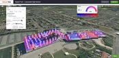
SmartViz Building Energy Solution Is Now Powered by iTwin
SmartViz Implementation with iTwin Platform for a School in Scotland SmartViz is now an even more comprehensive digital twin platform for boosting the performance of buildings and people London, United Kingdom - SmartViz, an intuitive digital twin platform that creates a virtual representation of indoor spaces, enabling building managers to optimize energy efficiency and space usage, is now integrated with the Bentley iTwin platform. The SmartViz platform, which saved Vodafone $...
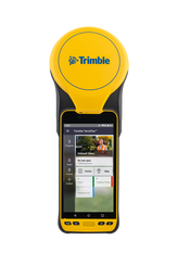
Trimble Introduces Next Generation High-Accuracy Mapping Solution for GIS Field Applications
SUNNYVALE, Calif.— Trimble (NASDAQ: TRMB) announced today a new high-performance data collector for its Mapping and Geographic Information Systems (GIS) portfolio—the Trimble® TDC650 handheld. Built for GIS data collection, inspection and asset management activities, the TDC650 provides users a rugged solution with scalable high-accuracy Global Navigation Satellite System (GNSS) positioning for professional field workflows. The TDC650 is fully integrated with today’s demanding GIS data envir...

PERI Formwork Systems, Inc. Announces VARIOKIT Pier System To Revolutionize Bridge Construction
Innovative VARIOKIT Pier System Bridges Safety and Efficiency ELKRIDGE, MD (July 12, 2022) – PERI Formwork Systems, Inc., one of the leading manufacturers and suppliers of formwork and scaffolding systems for today’s construction environment, is setting a new industry standard for bridge construction with the introduction of the company’s VARIOKIT Pier System (VPS). VPS bridges the gap between safety and efficiency to provide a versatile, rentable, and high-performing system for the smar...

Ideate Software Applications Aligned with Autodesk Revit 2023 and Deliver Significant Improvements for Revit Versions 2020-2022
San Francisco, CA – Ideate Software, an Autodesk® AEC Industry Partner and Autodesk® Authorized Developer, announced enhancements to its Revit plugin applications. In addition to aligning its software with Revit 2023, Ideate Software made significant improvements that will help Revit users deliver high-quality models in less time. Perform Time-Intensive Tasks in the Background with Ideate Automation 2.0 “One of the most significant changes made is the release of Ideate Automation 2.0, a sc...

IDS GeoRadar launches Stream DP with new Equalised scrambled Technology (EsT)
Stream DP is the new compact GPR array solution introducing the ground-breaking EsT technology that brings GPR performance to the next level: the deepest one yet. PISA, Italy (12 July 2022) — IDS GeoRadar, part of Hexagon, today announced the launch of Stream DP, an innovation for 3D utility mapping that uses multi-channel ground penetrating radar (GPR). Stream DP with the patented EsT technology enables efficient and safe performance in underground utility detection and mapping. EsT equalises...

CivilGEO’s GeoHECRAS is a 2022 Industry Leader with Top G2 Software Rankings
Widely recognized business solutions ratings platform, G2, has placed CivilGEO’s GeoHECRAS as its Summer 2022 Top Performer in the category of Best Civil Engineering Design Software. Basing its findings on over 100 reviews which awarded GeoHECRAS an average of 4.8 stars on a 5.0 performance scale, G2 placed CivilGEO’s software in the #1 spot representing 100% user satisfaction when compared to the top 20 performers in the category. In achieving the highest ranking in this sector, GeoHECRAS outpe...
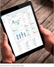
Siemens Launches Building X, an Open AI-Enabled Suite for Net Zero Buildings
Building X is the first next generation offering designed and built as part of Siemens Xcelerator Modular, scalable, open smart building suite that seamlessly integrates building systems to eliminate complexity and enable net zero Facilitates co-creation with partners to address digitalization challenges faster Siemens Smart Infrastructure has launched Building X, a new smart building suite that is open, interoperable and fully cloud-based. The suite is the first ne...
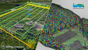
SPH Engineering and GreenValley International synchronize drone technologies for LiDAR data collection and processing
SPH Engineering and GreenValley International partner combining their expertise to deliver drone software technologies for LiDAR data collection and processing. The companies align UgCS mission planning software and LiDAR360 data processing software to optimize the workflow with LiDAR data collected with a UAV. The partnership is ready to provide a full end-to-end software toolchain for airborne LiDAR applications. It includes flight planning and data collection (done with UgCS) and data pr...
Video: Crashes Drop Measurably After Rural Road Safety Improvement Project on US 521 in Lancaster County

AdventHealth Weaverville Hospital

June Issue 2026
.jpg?width=225)