The Internet of Things: Coming to Facility Systems Near You!
Bob Dylan's iconic song, “The Times They Are A-Changin’,” still rings true for many things, including building infrastructure management. And the melody of change is the Internet of Things (IoT), which is facilitating smart city planning and smart home devices. IoT is integrated building automation on steroids. It’s resilient buildings; sustainable buildings. It’s building intelligence. Specifically, it’s a digital revolution that empowers facilities executives to relieve their “pain point...
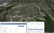
Green Infrastructure: Dallas Works to Quantify the Value of Parks
The City of Dallas Park and Recreation Department (DPARD) manages and maintains one of the largest municipal park systems in the United States, including more than 21,000 acres of parkland consisting of 381 individual parks featuring more than 4,400 surface acres of water and 125 miles of trails. The park system serves one of the fastest-growing metro areas in the country. This growth places unprecedented demand on the existing parks and trails, creating a need to expand and grow the system....

SimpsonHaugh And Partners Use Generative Design to Shape One Blackfriars Tower Concept
London’s leading property developer, St. George PLC, retained SimpsonHaugh Architects to fulfill a vision for mixed-use development at the junction of Blackfriars Road and Stamford Street at the head of Blackfriars Bridge in the central London borough of Southwark. The award-winning practice, ranked among the largest and most influential in the United Kingdom by Architects’ Journal, designed the GBP 250 million signature skyscraper One Blackfriars using GenerativeComponents, Bentley’s parametric...

Building Studio Delivers Complex Large-Scale Projects
When Gerard Outram, CEO of Building Studio, founded his business in 2007, he did so with an eye to the future. “As a start-up business owner, I knew the 3D world was a wave of the future and Bentley offered a great platform to help Building Studio meet our vision. “Over time, we’ve moved to new iterations of Bentley’s 3D design software – AECOsim Building Designer – and it’s been a fantastic platform for growing our business.” Based in Sydney, Australia, Building Studio uses Bentley softwa...
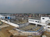
The Beauty Beneath: Notable Water and Sewer Networks Recognized
The Be Inspired Awards, awarded annually at Bentley Systems’ Year in Infrastructure Conference, are something like the Academy Awards of the infrastructure world—they recognize and celebrate design and construction achievements that often go unrecognized by the very citizens whose lives are being improved by applied practical genius. As Norman Maclean said, in the context of correctly loading pack mules, “To all those who work come moments of beauty unseen by the rest of the world.” The Year...
Transforming What Was Wet and Wasted in Wayzata
Declining Mall Redeveloped to Native Wetland Conditions By James W. Tiggelaar, PE, CCS, LEED AP The city of Wayzata, Minn., on the north shore of Lake Minnetonka, is a thriving community just 12 miles west of downtown Minneapolis. The lake has been a centerpiece of the community from its start as a vacation hub, and now the city is known more for executive offices and as a regional retail center. A beach, parks and walking/biking trails are interspersed with mansions that spread f...
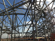
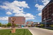
BIM Scores at San Jose Earthquakes’ New Stadium
Designed to provide the best possible experience for Major League Soccer fans, Avaya Stadium is among the world’s most technically and structurally advanced stadiums. By Edgar Enchano When flying into the San Jose International Airport, you can’t help but notice Avaya Stadium. Home to the San Jose Earthquakes, the $100-million, 18,000-seat stadium on Coleman Ave. rose from the dust of a long-abandoned factory adjacent to the airport. Designed to deliver a premium experience to soccer fans,...
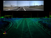
Consider the Benefits of Mobile LiDAR for Transportation Projects
Mobile LiDAR has become an effective solution for rapid data collection in recent years. For example, using mobile LiDAR imaging, the Utah Department of Transportation recently undertook a groundbreaking inventory of numerous roadway assets. Laser scanning is helping many state agencies comply with a new federal law requiring them to digitally map the U.S. National Highway System under the Moving Ahead for Progress in the 21st Century Act. Airborne light detection and ranging (LiDAR) technolo...
Mobile LiDAR Proves Cost Effective for Pavement Mapping
The Pennsylvania Department of Transportation (PennDOT) has used low-altitude mapping photography (LAMP), typically flown at 300 feet above mean terrain (AMT) via a helicopter, as a base for photogrammetry projects requiring high-accuracy pavement mapping and elevations. PennDOT also has been evaluating mobile light detection and ranging (LiDAR) technology to determine if it could replace LAMP. Initially, the increased cost and unanswered questions regarding accuracy and control requirements...

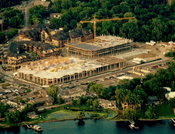
John McAslan + Partners Uses 3D Modeling to Facilitate Design of King’s Cross Station
Built in 1852, King’s Cross railway station is one of the main transportation hubs in London. As with the rest of the United Kingdom’s rail network infrastructure, the station has struggled in recent years to manage not only increasing ridership but also providing the space and amenities commuters expect. The GBP 547 million redevelopment of King’s Cross station is at the heart of one of the largest regeneration undertakings in Europe, with 67 acres of brownfield land being redeveloped to...
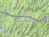
Video: New Roundabout Under Construction at McIver and Old Florence Roads in Darlington County

Promenade at The Point

June Issue 2026
.jpg?width=225)