
Sponsored Content: Photo Capture: Another Big Leap for Survey Technology
More Projects, Bigger Projects, Done More Frequently For land surveyors and other mapping and measurement professionals, photo capture of 3D environments can seem like yet another sudden and threatening arrival of a disruptive technology—GNSS, robotic total stations, RTK, laser scanning and UAS all come to mind. On one hand, use of just a “pretty good” digital camera, plus software, to create accurate 3D models of complex environments seems to threaten existing investment in laser-scanning eq...

New U.S. Bank Stadium Complete
Construction of the new U.S. Bank Stadium in downtown Minneapolis is substantially complete and ready for business. Finished six weeks ahead of schedule, the new stadium and home of the Minnesota Vikings features a bold, iconic design. Contractor Mortenson Construction symbolically turned over the stadium’s keys to the Minnesota Sports Facilities Authority (MSFA), the building’s owner, and the Minnesota Vikings during the MSFA’s June board meeting. The architectural landmark is 1.75 millio...
Sponsored Content: Top Five Reasons to Combine Autodesk's AutoCAD Civil 3D with InfraWorks 360 for Improved Civil Design
The dynamic duo of AutoCAD Civil 3D and InfraWorks 360 are a powerful combination for improving workflow efficiency for civil infrastructure design. The editorial team at Informed Infrastructure recently completed a detailed benchmark study (www.v1-education.com) of the use of these tools in tandem, showing the time savings and workflows that several independent reviewers achieved on sample projects. Following is a summary of the top-five takeaways of improved workflow and insight when combining...
The Village at Westfield Topanga: Strict Runoff Regulations Require Creative Solution
In 1964, the first enclosed shopping mall in California opened its doors. Located in Canoga Park, a neighborhood in Los Angeles’ San Fernando Valley, Westfield Topanga is a two-level, 1.6-million-square-foot indoor shopping center. In 2015, its owners embarked on a major expansion directly across from the original mall. Called The Village at Westfield, the 31-acre expansion is a mixed-use project designed to be a community destination in the heart of the West Valley. The developer, Westfield...
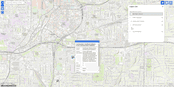
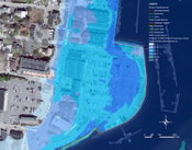
A Watershed Moment in Public Alerting
A real-time web map goes a long way to prevent sickness when force majeure strikes. Last winter, a torrential storm caused two water pump outages in Atlanta, Georgia, risking contamination and necessitating a boil water advisory be issued to affected residents. To widen its outreach, the Atlanta Department of Watershed Management (DWM) used social media and the local news to promote a mapping Web site that showed the areas affected by the outages. Smart Notification If it’s not live, an...
The Climate Response—Government Leaders Take Action, Evaluate Vulnerabilities Due to Climate Change
By Nathalie Beauvais, Robert Brandon and Indrani Ghosh Across the country, government and industry leaders are taking a close look at the potential effects of climate change. What happens to people, buildings and infrastructure when extreme heat extends from a few days to a few weeks? When the one-in-100-year storm of today becomes the one-in-25-year storm of tomorrow? When sea levels rise above safe boundaries? The answers to these questions and many others are neither quick nor easy...
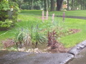
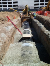
Don’t Lose Your LID—Learn These Lessons for Effective Stormwater Drainage
The concept of stormwater management under Low-Impact Development (LID) is fairly simple: it’s based on how nature handles rainfall in an undisturbed environment of meadows and woods. Nature works with simple concepts such as rainfall interception by the branches of a tree, which slows the velocity of a falling raindrop, which then lands on a soft bed of decaying organic matter on top of the soil. The organic layer further allows the rain to filter in and around the matter and then infiltrate in...
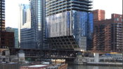
Tower of Power: Strong Steel Overcomes Constraints at a Tight Site
In Chicago, one of the world’s architectural capitals, it’s not uncommon to see unusual buildings, innovative designs and creative construction techniques. The winds are strong, the soil is poor, and there are a lot of regulations and coordination required to build. Overcoming the technical challenges associated with the unique design and construction of today’s highrises frequently is lauded by industry and the general public, as the buildings shed their boxy shapes and reach ever higher t...
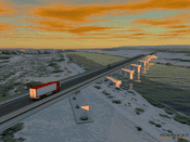
Washington State Department of Transportation Uses 3D Immersive Visualization
The Washington State Department of Transportation (WSDOT) Visual Engineering Resource Group (VERG) uses Bentley’s 3D immersive visualization software, LumenRT, to create images, videos, and real-time presentations for use in such diverse applications as design reviews, courtroom legal support, and cultural resource documentation. VERG has gained national recognition for producing visual communications that explain complicated stories to a mass audience in a compelling and engaging way. Solutio...

Reality Modeling for Everyone
Highly Accurate Context from Simple Photography Before beginning any infrastructure project, a project team needs to survey existing conditions in order to provide the foundational input to the decision-making process—to understand the context within which the asset will be designed, built, and operated. The technologies and processes available to capture and visualize real world conditions have evolved beyond levels and tape measures to technologies such as Total Stations, aerial and gro...
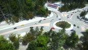
Video: New Roundabout Under Construction at McIver and Old Florence Roads in Darlington County

Promenade at The Point

June Issue 2026
.jpg?width=225)