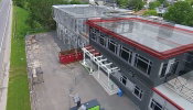
Augmenting Drone Videos could Facilitate Construction Monitoring
Augmented reality is a fascinating technology that could change the way we live and interact with the world that surrounds us. Unfortunately, we don’t see many good applications of AR in engineering yet, partly because achieving good visual integration of digital objects with reality is very challenging. To display the augmented elements at the right location on a tablet display at every instant, the AR app must know the position of your tablet in real time - that is fundamental to AR. Now th...
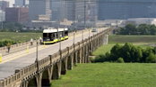
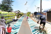
HDR Delivers Texas’ First Modern Streetcar System
The Union Station to Oak Cliff Dallas Streetcar TIGER Project is Texas’ first modern streetcar system. The project is a collaborative endeavor between the City of Dallas, North Central Texas Council of Governments (NCTCOG), Dallas Area Rapid Transit (DART) and the U.S. Federal Transit Authority (FTA). The 1.6 mile line received a USD 26 million Transportation Investment Generating Economic Recovery (TIGER) grant, separating itself from the other 17,000 TIGER grant applicants, due to its econo...
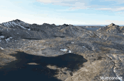
Creating Real-time Navigable 3D Infrastructure Models
Designing successful infrastructure projects is one thing. Communicating and demonstrating those designs to clients and other stakeholders before construction is another. Bringing a design to life for people without a civil engineering background is always a challenge, whether your goal is to sell the design or communicate its impact. Over the decades, civil engineers have used everything from elaborate hand drawings to carefully constructed physical models for this purpose. Then, in the 1990...

Rethinking Rail Signal Design
Global consulting engineering firm Hatch Mott MacDonald had used a conventional CAD-based system to design rail signal systems when serving its public and private clients around the world. However, this approach had serious limitations in an industry where building information modeling (BIM), the processes and standards that define it, are becoming a critical success factor. Traditional methods mean designs have no added intelligence or connections to related documents including bills of mate...
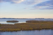
Wetlands Worth their Weight
Monitoring, Managing and Protecting Ecological Powerhouses “Wetland” is a generic term covering a wide variety of habitats that are wet for at least some period of time each year, have vegetation, and have soils that are saturated long enough during the growing season to produce oxygen-deficient conditions. Although they can vary tremendously depending on climate and topography, all wetlands promote the growth of different types of microbial, plant and animal communities. Wetlands attenuat...
Oxnard to Turn Alleys Into Amenities
The Oxnard Green Alleys Plan is a guidebook developed by the international landscaping firm SWA for the City of Oxnard to transform its underutilized alleys into amenities that provide multiple benefits to the community. The Oxnard Green Alleys Plan guides revitalization of Oxnard's alleys for providing bicycle and pedestrian connections, improving storm water quality, mitigating the urban heat island, creating open space for community recreation, and supporting local businesses. Challen...
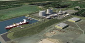
Oregon Preparing for Export: Assessing the Seismic Challenges of a Liquified Natural Gas Plant
In the international port of Coos Bay, Ore., construction will begin in late 2016 on a liquefied natural gas (LNG) export terminal that will be the largest private construction project in the state’s history. The bay is separated from the ocean by a tongue of land varying in width from 0.3 miles at the entrance to 1.9 miles at Jordan Cove, where the plant will be built. The facility requires access to the ocean for the deep draft vessels that will move its cargo to customers across the Pacifi...
Prioritizing Data Management: The Shortest Distance to Project Quality
By Darius Šimkūnas In the Baltic States, Kelprojektas is the largest group of infrastructure engineering companies that designs transport infrastructure, public buildings and engineering systems as well as conducts regional planning. The company was established in 1956 and has successfully delivered more than 6,000 infrastructure projects. Today, there are more than 300 employees working with the most-advanced software, including the largest number of Autodesk-certified specialists in the Balt...
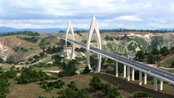
Better in 3D: How 3D Modeling Helped Overcome Complexity in Building the Longest Cable-stayed Bridge in Africa
When Morocco’s highway company, Autoroutes Du Maroc (ADM), undertook a highway bypass project in 2010 that would cross the Bouregreg River, they could have built a traditional viaduct. Instead, they set out to construct Africa’s longest and tallest cable-stayed bridge. The resulting project presented unique and complex challenges that called for innovative solutions. The Bouregreg River runs from the Atlas Mountains to the Atlantic coast between the cities of Rabat and Salé in western Morocco...
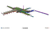
Oslo Airport Expansion: Open BIM Approach Improves Project Efficiency
By Bjørnar Markussen Avinor Oslo Airport plays a crucial role as the hub of Norway’s aviation system, serving domestic and international passenger and cargo flights. Upon opening in 1998, the new airport boosted its capacity to handle 17 million passengers annually, but less than a decade later, it was clear that demand would soon outgrow capacity. It was then that the board of Avinor, owner of the airport, began planning a major expansion in close collaboration with airlines and handling...
Video: New Roundabout Under Construction at McIver and Old Florence Roads in Darlington County

Promenade at The Point

June Issue 2026
.jpg?width=225)