
PERI Formwork Systems, Inc., Upgrades QuickSolve, Empowers Contractors with Even More Powerful Online Planning Tool
Enhanced Web-Based Platform Streamlines Data Capture, Provides Greater Functionality ELKRIDGE, MD (July 20, 2021) – PERI Formwork Systems, Inc., one of the leading manufacturers and suppliers of formwork and scaffolding systems for today’s construction environment, has released an enhanced edition of PERI QuickSolve, a free web-based planning tool that empowers contractors and estimators to sketch out a project and identify the best wall formwork solutions based on the specific characterist...

HDR Expands Capabilities of its Proprietary Zero Emissions Fleet Optimization and Feasibility Modeling Tool
OMAHA, Neb. — HDR has upgraded its proprietary Zero+ Fleet Optimization and Feasibility Modeling Tool to evaluate all manner of fleets more precisely. The upgraded tool will better serve fleet owners making zero emissions transitions, with detailed analysis of power consumption and vehicle capabilities. Working with international research and development consultant Mitacs and the globally recognized University of Toronto, HDR integrated greenhouse gas emissions as an output capability and a...
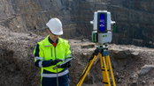
Maptek consolidates on field benefits for high accuracy survey-grade sensors
A new dual-window scanner that halves data capture time headlines the latest Maptek mine measurement improvements. The exciting new Maptek XR3-D mkII laser scanner with dual window arrangement cuts scan acquisition time in half. Conventional terrestrial laser scanners capture data from one window, spinning to achieve a 360° field of view; the XR3-D captures data from both sides simultaneously, with the scanner head only needing to spin 180°. ‘Survey crews can incidentally scan surroun...
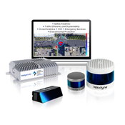
Velodyne Lidar Partners with NVIDIA Metropolis for Intelligent Infrastructure Solutions
City of Austin, Texas, Selects Velodyne’s Solution for Traffic Safety Pilot Project SAN JOSE, Calif. (July 14, 2021) – Velodyne Lidar, Inc. (Nasdaq: VLDR, VLDRW) today announced it has joined the NVIDIA Metropolis program for Velodyne’s Intelligent Infrastructure Solution for traffic monitoring and analytics. NVIDIA Metropolis is designed to nurture and bring to market a new generation of applications and solutions that make the world’s most important spaces and operations safer and more ef...
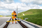
New Trimble GEDO GX50 Laser Scanning System Introduced for Clearance Analysis and Asset Data Collection for Railway Applications
Innovative and Flexible Laser Scanning Solution Designed to Assist Railway Track Surveying Professionals SUNNYVALE, Calif. — Trimble (NASDAQ: TRMB) introduced today the Trimble® GEDO GX50, a flexible laser scanning system designed to operate with Trimble GEDO track measurement systems for clearance analysis and asset data collection, further enhancing the modular track survey and scanning solutions portfolio. The Trimble GEDO GX50 features new Trimble-designed profiling lasers for high...
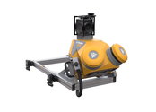
Trimble MX50 LiDAR System Expands Mobile Mapping Portfolio
Vehicle-Mounted System Enables Data Capture for Road Agencies and Local Governments SUNNYVALE, Calif.— Trimble (NASDAQ: TRMB) introduced today the Trimble® MX50 mobile mapping system for asset management and mapping—a new addition to its established mobile mapping portfolio. This vehicle-mounted mobile LiDAR system is a mid-range option for first-time mobile mapping users and experienced providers to expand their equipment fleet with precise, high-volume data capture technology that works...

CompassCom releases CompassTrac v7.8 and becomes an approved Esri ArcGIS Marketplace provider
DENVER, CO – July 13, 2021 – CompassCom Software Corp., a leading provider of real-time fleet tracking and management solutions is pleased to announce the immediate availability of version 7.8 of CompassTrac® as well as becoming an approved Esri ArcGIS Marketplace provider. The features within the 7.8 release increase visibility and provide real-time key performance indicators to improve fleet efficiencies and enhance asset management. These include Realtime User Dashboards, Driver Behavio...
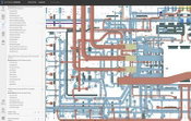
Autodesk Tandem: Digital Twin Platform Now Commercially Available
SAN FRANCISCO — Autodesk, Inc. (NASDAQ: ADSK) announced the commercial availability of its cloud-based digital twin platform, Autodesk Tandem, following its successful public beta. As plans and files change throughout the design and construction process, keeping data together is challenging. A recent FMI report reveals that more than 95 percent of all data goes unused in engineering and construction, which results in inefficient processes and lost revenue for AEC firms and owners. "Au...
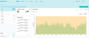
Aircuity Introduces New ‘Airside’ Energy Dashboard to Increase Building Owners’ Ability to Meet Enhanced Sustainability Targets
New ventilation analytics provide insight, down to room level, to measure key areas of energy consumption NEWTON, Mass., USA – Aircuity, the leader in creating healthy and sustainable buildings, today introduced a new “Airside” Energy Dashboard that lets building owners quickly identify which areas across the entire portfolio are consuming the most ventilation energy. By providing data that goes all the way down to the room level, the new dashboard helps building owners identify the root ca...
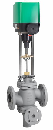
CIRCOR announces RTK® Discharge and Pump Protection Control Valve
Cutting Cost and Preventing Damage with Two Valves in One CIRCOR International, Inc., a leading manufacturer and marketer of differentiated technology products and sub-systems, announces the RTK® Discharge and Pump Protection Control Valve. This unique valve provides the ideal solution for all industrial processes that incorporate pumps, such as condensate pumps, boiler feedwater pumps, or low-pressure centrifugal pumps. The RTK® Discharge and Pump Protection Control Valve works as two...
Video: New Roundabout Under Construction at McIver and Old Florence Roads in Darlington County

Promenade at The Point

June Issue 2026
.jpg?width=225)