
FARO® Launches Freestyle 2 Portable 3D Scanner
Lake Mary, FL — FARO Technologies, Inc. (NASDAQ: FARO), the global leader for 3D Metrology, AEC, and Public Safety Analytics, today announced the release of its most portable and advanced handheld 3D forensic scanner: Freestyle 2. Ideal for investigators and reconstructionists who require fast and complete scene documentation, Freestyle 2 provides immediate real-time visualizations with photorealistic reality capture capabilities. The result is unmatched confidence that what is captured is accur...

Cityzenith Unveils New Highly-advanced Digital Twin Technology: SmartWorldPro2
Cityzenith today unveiled its long-awaited Beta release of SmartWorldPro2, the follow-up to its flagship Digital Twin software platform, SmartWorldPro – the go to planning, building and infrastructure tool for city planners and asset managers. Digital Twins are 3D virtual replicas of physical buildings and infrastructure connected to the data in and around them, and widely used to optimize their design, construction, and operational performance over the entire lifecycle. Cityzenith CEO Mic...
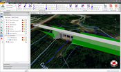
CivilGEO Releases GeoHECRAS Version 3.0
Wisconsin, July 07, 2020 - CivilGEO, a leading provider of civil engineering software, has released a new version of the GeoHECRAS software. GeoHECRAS Version 3.0 utilizes an improved and easier to operate FlexNet software licensing technology from Flexera Software. This latest release provides key new features, updates, and bug fixes. GeoHECRAS is an AutoCAD, Bentley MicroStation and ESRI ArcGIS compatible interactive 2D/3D graphical user interface data wrapper to U.S. Army Corps of Engineer...

Project ASLAN steers a new course for autonomous urban mobility
Unprecedented international collaboration to accelerate the commercial viability of autonomous vehicles in cities with the launch of a fully-functional open-source self-driving platform Global not-for-profit open-source collaboration with founders from Australia, Asia-Pacific and Europe The project announces ‘go live’ on a completely free and rapidly deployable open-source self-driving software stack for urban low-speed autonomy Project ASLAN invites additional capability to supp...

Revit Software Users Can Now Link PDF and Microsoft Word Documents to Revit Files Thanks to Ideate Sticky
San Francisco, CA – Ideate Software, a veteran Autodesk Developer Network member, announced that recent updates to Ideate Sticky include one of the features most requested by Autodesk Revit software users. “As a developer of software that streamlines Revit workflows, we closely monitor the Autodesk Ideas Forum to identify Revit challenges we can address through our productivity tools,” said Glynnis Patterson, Director of Software Development. “We heard loud and clear that Revit users wanted t...
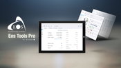
Eos Positioning Systems Releases Eos Tools Pro for Windows
Eos’s new GNSS app for Windows 10 devices is loaded with new, powerful features and a colorful user interface. For developers, integrating high-accuracy Arrow receivers is faster and easier than ever before JUNE 23, 2020, MONTREAL, CANADA — Eos Positioning Systems, Inc.® (Eos) — the leading manufacturer of high-accuracy Arrow Series® GNSS receivers for the GIS, engineering, construction, and surveying community — announced today the release of Eos Tools Pro for Windows 10. Eos Tools Pro imp...

Contech Engineered Solutions Announces New Version of the Design Your Own Detention System Tool
West Chester, OH – Contech Engineered Solutions released the latest version of its industry leading Design Your Own Detention System tool, an online program for designing stormwater detention and infiltration systems constructed with Contech corrugated metal pipe (CMP). The newest release provides engineers unparalleled flexibility in the layout and configuration of underground detention systems. The free tool is available at www.conteches.com/dyods. The release includes new functionality pre...

Woolpert to Provide Information Technology Archives and Information Management (AIM) Support Services for DOE Office of Legacy Management
The IDIQ contract will help the Legacy Management Support team deliver long-term sustainment of Department of Energy post-closure sites across the country. WASHINGTON, D.C. (June 24, 2020) — Woolpert has been contracted to provide the U.S. Department of Energy (DOE) Legacy Management Services (LMS) team with information technology, records and information management, and Environmental Spatial Data Management (ESDM) to support activities for DOE Office of Legacy Management (LM) sites located t...

Microdesk Expands BIMrx Product Line with Tailored Solutions for Design and Construction
New York, NY - Global BIM and EAM consulting firm Microdesk, a leading provider of business and technology services for the design and construction industry, has expanded its comprehensive BIMrx® portfolio with the release of BIMrx Fabrication and BIMrx MEP as well as updates to BIMrx Core. Each of these custom-tailored solutions allow Architects, Engineers and Contractors to streamline workflows and maximize efficiency within Autodesk Revit. BIMrx Fabrication was built by construction profes...
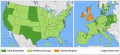
HxGN Content Program Updates 3 Million Square Kilometers of Aerial Data in U.S., Europe in 2020
WASHINGTON, D.C., USA (23 June 2020) — Hexagon’s Geosystems division announced today the HxGN Content Program, the largest library of high-accuracy airborne data, is updating 3 million square kilometres in 2020 of high-accuracy four-band orthophotos, digital surface models (DSM) and stereo imagery across the United States and Europe. In North America, the HxGN Content Program will update 2.5 million square kilometres of aerial data, close to a third of the continental United States. This incl...
Video: New Roundabout Under Construction at McIver and Old Florence Roads in Darlington County

Promenade at The Point

June Issue 2026
.jpg?width=225)