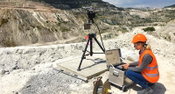
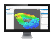
IDS GeoRadar Launches Compact Safety Monitoring Radar for Mining
(Pisa, Italy, 19 April 2018) – IDS GeoRadar, a leading provider of Ground Penetrating Radar (GPR) and interferometric solutions worldwide, today launched HYDRA-X, a radar-based technology solution specifically designed to support geotechnical engineers in the mining industry. HYDRA-X supports the different types of mine site needs, ranging from strip coal mines, tailing dams, small open pits, quarries and sub-benches monitoring in huge open pits. HYDRA-X is a compact radar solution that is ea...
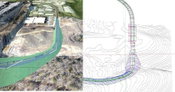
What’s New in InfraWorks and Civil 3D 2019
InfraWorks roads imported to Civil 3D 2019 automatically generate as Civil 3D corridors. Autodesk recently announced the latest releases of Autodesk® InfraWorks® and Autodesk® Civil 3D® 2019. These software releases provide enhancements for closer collaboration, improved design, more efficient drawing production, tighter interoperability, and smoother data exchange. Below are the key enhancements for both products. InfraWorks Collaboration Enterprise cloud collaboration with BIM...
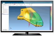
FARO Introduces CAM2 2018 3D Measurement Software Platform
Lake Mary, FL - FARO® (NASDAQ: FARO), the world’s most trusted source for 3D measurement and imaging solutions for factory metrology, product design, and 3D machine vision applications, announces the release of the FARO CAM2 2018 software platform, specifically designed to enable users to realize the highest value and level of performance with all FARO metrology products across the automotive, aerospace, machine tools and metal fabrication industries (http://www.faro.com/cam2/sg). CAM2 2018 elev...
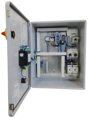
Weil Pump’s Line of PLC Panels Offers Flexibility and Complete System Control
Cedarburg, WI. Weil Pump’s line of Programmable Logic Controller (PLC) panels provides a powerful platform for the control of most pumping systems, including commercial, industrial, process and booster service pumps. The PLCs are built in-house at Weil’s production facility in Cedarburg, WI, centralizing the product line’s manufacture and testing. The panels have the flexibility to control up to four pumps and work with a variety of level controls, from state-of-the-art transducers to traditiona...
Topcon Announces New Features Added to Web-Based Service for Mass Data Processing Software
LIVERMORE, Calif., U.S./ CAPELLE A/D IJSSEL, the Netherlands – Topcon Positioning Group announces an update to MAGNET Collage Web — its web-based service for integration with the MAGNET® Collage desktop mass data processing software. MAGNET Collage Web version 1.1 offers new features and improvements designed to simplify collaboration and sharing of 3D point cloud data. The update includes an embeddable public viewer designed to allow operators to send a link or embed a viewer to access a ma...
TVP's World-Best Solar Thermal Panel Certified and Proven
Int'l Certification: best efficiency verified under Solar Keymark up to 200°C Commercial Validation: massive yearly thermal energy supply cuts client operating costs The Future Of Energy: solar thermal proven to beat traditional fuel prices TVP Solar announces the one-year study of its solar thermal panels at a live client site in Kuwait. The results prove TVP's best-in-class performance operating up to 200°C as recently certified by Din Certco Solar Keymark. The solar field in Kuw...

Lorin Announces Perforated Coil Anodized Aluminum, Ideal for Architectural and Construction Applications
Muskegon, MI - Lorin Industries, Inc., the global industry leader in the innovation and production of coil anodized aluminum, announces the availability of its coil anodized aluminum for perforated aluminum projects in architectural and construction applications. Perforated anodized aluminum delivers functionality, superior durability, and excellent aesthetics. The cost-effective coil anodizing process, pioneered by Lorin, protects the aluminum while also improving its aesthetic properties and d...
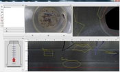
Manhole Inspection Streamlined with New Module for WinCan
Pittsburgh, PA—April 10, 2018—The new Manholes Module for WinCan sewer assessment and asset management software makes it easy for municipalities to integrate manhole inspection into their sewer management workflow. The module imports imagery and geometric data from automated manhole inspection equipment and gives the user powerful tools to: Analyze: The Manholes Module combines imagery and geometric data to create a virtual manhole where users can descend, pan, tilt and zoom to scruti...

Fairview Microwave Introduces New Online RF Cable Designer Tool
LEWISVILLE, Texas - Fairview Microwave Inc., a leading provider of on-demand RF and microwave components, has introduced a new online custom cable creator tool that allows engineers and buyers to design, customize and purchase hundreds of different combinations of custom RF cable assemblies. Fairview Microwave’s RF Cable Designer™ allows engineers and buyers to quickly and easily create customized RF cable assemblies from a wide selection of connectors and cable types offered by the company....

Beamex Launches Intuitive and Powerful Multi-platform Mobile Paperless Solution for Executing and Documenting Calibrations and Maintenance Inspections
The concept of a paperless calibration process is not new, yet many companies still use paper based solutions for executing and documenting calibration events, ignoring the many improvements that a paperless solution can bring, such as efficiency and data quality improvements. Beamex has long provided paperless calibration solutions using CMX Calibration software as an online solution and with Beamex Documenting Calibrators in an offline mode. bMobile 2.0 complements both the CMX software and...
Video: New Roundabout Under Construction at McIver and Old Florence Roads in Darlington County

Promenade at The Point

June Issue 2026
.jpg?width=225)