
Baron Releases Solution for Departments of Transportation
Huntsville, AL – Baron, the worldwide provider of critical weather intelligence, has released a new product offering specifically designed for Department of Transportation services across the U.S. The solution will provide a single comprehensive source for the display and monitoring of current and forecasted weather conditions. Components of the product include a network operations display, mobile app, custom location alerting and the ability to integrate a state’s RWIS (Road Weather Sensor) dat...

Wilo USA Extends Range of Powerful Wilo-Stratos GIGA Line
Rosemont, IL. Wilo USA, a provider of pumps and pump solutions for water management, building services and groundwater, is pleased to announce an extended range of models for the Wilo-Stratos GIGA line of centrifugal pumps to include three and four inch models, bringing the total offering of the Wilo-Stratos GIGA line to 28 models. The Wilo-Stratos GIGA is a space-saving in-line circulator with ECM technology that is designed for use in hot water heating systems, air conditioning, closed...
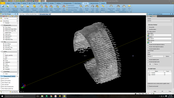
Trimble’s New Tunnel Solutions Streamline Workflows for Survey and Engineering Professionals
SUNNYVALE, Calif. — Trimble (NASDAQ:TRMB) announced today a suite of solutions that enhances productivity and efficiency for surveyors and professionals working on underground tunneling projects. The solutions include new hardware and software for capturing highly accurate data in tunnels where dirt, dust, water and machinery provide a challenging work environment. The new line of products reduce the time to generate project deliverables by enabling survey and tunneling engineers to easily compa...
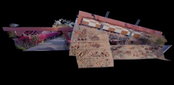
Leica Geosystems and Frank Lloyd Wright Foundation Team Up to Transform Taliesin West into an Immersive Online 3D Experience
HEERBRUGG, Switzerland & SCOTTSDALE, Ariz.- Leica Geosystems, part of Hexagon, industry leader in measurement technology, today announced a partnership with the Frank Lloyd Wright Foundation to capture, document, and deliver immersive 3D experiences featuring the iconic architect’s properties. Taliesin West, Frank Lloyd Wright’s winter home and studio, is the first property that will be made available through an immersive online experience led by Leica Geosystems. The Arizona property attract...

Trimble Catalyst Now Supports GLONASS, Delivering Faster, More Accurate and Reliable Positioning Performance
SUNNYVALE, Calif. —Trimble (NASDAQ: TRMB) announced today that its Trimble® Catalyst™ software-defined Global Navigation Satellite System (GNSS) receiver for Android phones and tablets has been updated to support GLONASS. The update demonstrates the advantages of software GNSS for delivering new functionality faster and easier. Access to the GLONASS constellation increases the number of GNSS satellites visible when working in the field. As a result, it improves the ability to maintain lock on...

Streamlining Automated Inspection Technology for Transportation
Avitas Systems, a GE Venture, provides state-of-the-art, robotic based autonomous and semi-autonomous inspection management, smart scheduling, and safety compliance. The Avitas Systems cloud based platform uploads inspection data from a wide variety of sensors, fuses the data with regulatory and external sources, such as weather, and outputs advanced risk-based insights that are accessible 24/7 via an online inspection interface and mobile application. The Avitas Systems solution protects asse...

Michael Baker International Revolutionizes Next-Generation 9-1-1 Transition with New DATAMARK® VEP GIS Solution and Services
Michael Baker International, a global leader in engineering, planning and consulting services, today announced that its geographic information system (GIS) business launched DATAMARK® VEP (Validate-Edit-Provision), a new software-as-a-service (SaaS) solution that validates, edits and provisions GIS data. The new solution is for both current 9-1-1 systems and the transition to next generation 9-1-1 (NG9-1-1) systems and is augmented with GIS technical services and an expanded DATAMARK team that i...

Hexagon Introduces World’s First 3D Laser Scanner with Automatic In-Field Pre-Registration
Hexagon AB, a global leader in digital solutions, today announced the launch of the Leica RTC360, a laser scanner equipped with edge computing technology to enable fast and highly accurate creation of 3D models in the field. It’s one of the many innovations on showcase this week at HxGN LIVE 2018, Hexagon’s annual digital technology conference. The RTC360 combines high-performance laser scanning, edge computing, and mobile app technologies to pre-register captured scans quickly and accurately...
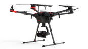
Leica Geosystems Combines New UAV Technology with DJI Aerial Platform to Complete Flight Missions in Less Time
(Heerbrugg, Switzerland) – Leica Geosystems, part of Hexagon, industry leader in measurement technology, announced today the new Leica Aibot, the latest Unmanned Aerial Vehicle (UAV) system based on DJI’s aerial platform, the M600 Pro, to rapidly and autonomously acquire mobile 3D mapping data. The new Leica Geosystems UAV technology allows users to get a complete data set in less time with a user-friendly and innovative interface, opening new business opportunities while spending less time,...

New Leica iCON Construction Total Stations Provide Efficient Layout Solution
(Heerbrugg, Switzerland) – Leica Geosystems, part of Hexagon, industry leader of measurement technology, announced today the new Leica iCON construction total stations, Leica iCR70 and Leica iCR80, the most productive one-person layout solution for building construction. The intuitive new iCON construction total stations increase efficiency on any building construction site by automatically identifying the prism and automatically relocking to it, should the line of sight be lost, deliverin...
Video: New Roundabout Under Construction at McIver and Old Florence Roads in Darlington County

Promenade at The Point

June Issue 2026
.jpg?width=225)