Nonprofit ‘Renewable Nation’ App Targets 9 Out of 10 Solar-Ready Homes That Have Not Gone Solar
WASHINGTON, D.C. – More than nine out of 10 solar-ready homes and schools in the United States have not yet gone solar and the new app-driven Renewable Nation and its “Solar Schools 2025” program intend to do something about that. The Renewable Nation app is available now on the Google Play store and iTunes. Renewable Nation is an independent non-profit effort dedicated to accelerating the adoption of safe, affordable and clean energy. Additional information about the app-based effort is a...
Trimble Continues Evolution of Video Intelligence with Introduction of Intelliview and High-Definition Video Capture
HOUSTON - Trimble (NASDAQ : TRMB ) debuted today two enhancements to its Video Intelligence platform. These enhancements include the introduction of the Intelliview™ feature and the availability of a new camera and digital video recorder (DVR) that capture high-definition (HD) video. The announcement was made at Trimble's third annual in.sight user conference + expo. Intelliview helps filter different Onboard Event Recordings (OER)-triggered events by categorizing videos as primary or seconda...
Trimble Enhances its TruETA Solution with New Add-On Modules for Improved Route Planning
HOUSTON - Trimble (NASDAQ : TRMB ) announced the introduction of enhancements to its TruETA solution for improved route planning. While estimated time of arrivals (ETAs) are not new to the trucking industry, the application adds a new dynamic to the solution—driver intent. The announcement was made at Trimble's third annual in.sight user conference + expo. Most TMS systems allow for visibility of a route's speed limits, traffic delays and weather factors, among other things. But, along with t...

FARO® Introduces the ScanPlan™ Handheld Floor Mapper
Lake Mary, FL — FARO® (NASDAQ:FARO), the world’s most trusted source for 3D measurement and imaging solutions for public safety forensics and factory metrology, announces the availability of FARO® ScanPlan™ (www.faro.com/scanplan/sg), a solution for fast and easy mapping of floor plans. This next generation 2D handheld mapper is specifically designed to enhance the effectiveness of public safety professionals such as emergency responders, fire and crime scene investigators and security managers....
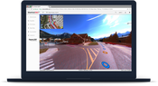
Solv3D Releases New Features within SiteVisit360™ Geospatial Collaboration Platform
CALGARY – September 6, 2018 – Solv3D Releases New Features within SiteVisit360™ Geospatial Collaboration Platform. Solv3D, a leading provider of 3D processing, geospatial data visualization and collaboration tools announced that a number of new features were currently released within SiteVisit360™, further enhancing the client’s experience and making it an even more efficient and effective tool in enabling visualization and collaboration of geospatial data across the enterprise. The first...
Boral Resources Offers Sintered Light Weight Aggregate Production Technology
ATLANTA - Boral Resources has secured commercialization rights for the United States for a technology to manufacture ceramic light weight aggregate from high carbon ash. The resulting aggregate can be used in a variety of construction applications. High carbon ash generated from current coal-fueled electricity production, or recovered from landfills or ponds, can be used as feed material to manufacture the aggregate. Thus, in addition to producing a marketable product, the technology can help...
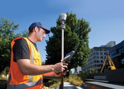
Trimble Launches New Model of its R10 GNSS System for Land Surveyors
SUNNYVALE, Calif. —Trimble (NASDAQ: TRMB) today announced the launch of a new model of its premium Global Navigation Satellite System (GNSS) receiver, the Trimble® R10 Model 2 GNSS System. Designed to help surveyors in a wide range of industries work more effectively and productively, the Trimble R10 Model 2 enables reliable, fast and accurate collection of survey data in the field. The new enhancements include: The latest and most advanced custom Trimble survey GNSS ASIC with an industry-...
FARO® Announces SCENE 2018 with FARO Laser-HDR™ and High Detail Scanning
Lake Mary, FL— FARO® (NASDAQ:FARO), the world’s most trusted source for 3D measurement and imaging solutions for construction BIM, announces the release of SCENE 2018, a tightly integrated software platform specifically designed for the FARO Focus Laser Scanner product family. This introduction represents a substantial leap forward for 3D reality data capture and the FARO-driven concept known as Traceable Construction™, in which optimizing the entire AEC construction lifecycle is accounted for i...
Bentley’s SACS Provides Advanced Analysis and Workflow Enhancements for Offshore Structures
Bentley Systems announces enhancements to its latest release of SACS CONNECT Edition, an offshore structural analysis application that offers fully automated and integrated 3D modeling, analysis and design to efficiently manage large, complex models for the evolving digitalization in the offshore market. This new release of SACS includes capabilities that help eliminate disjointed workflows and data, enhances interoperability with other applications, ensures safe structural performance during...
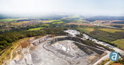
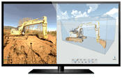
SimActive for Mining: Drones & Volume Calculation
Montreal, Canada – SimActive Inc., a world-leading developer of photogrammetry software, is proud to announce new features to improve volumetric calculation. Correlator3D™ now has integrated tools for users to generate precise statistics on mining activities. Applications like mineral extraction monitoring can all be done seamlessly within the software. Users can process raw drone data, produce point clouds and DSMs, and perform volumetric calculations, all in the same Correlator3D™ workflow...
Video: New Roundabout Under Construction at McIver and Old Florence Roads in Darlington County

Promenade at The Point

June Issue 2026
.jpg?width=225)