Guyana, a small nation on the northern coast of South America, is one of the fastest-growing economies in the world. According to the International Monetary Fund, Guyana recorded the highest real GDP growth rate in the world, averaging 47 percent per year between 2022 and 2024, driven by a significant oil boom that triggered an unprecedented wave of infrastructure investment. Roads, highways and civil works are being developed at a pace that demands speed and smarter construction methodologies.
One of these smarter methodologies is building information modeling (BIM), a collaborative working methodology that centralizes all project information—geometry, materials, schedules and costs—into a single coordinated digital environment. Unlike traditional design and construction workflows, where each discipline works in isolation and problems are discovered onsite, BIM allows all stakeholders to work from the same model, detecting design and construction conflicts during the project’s early stages, when changes are still manageable and inexpensive.
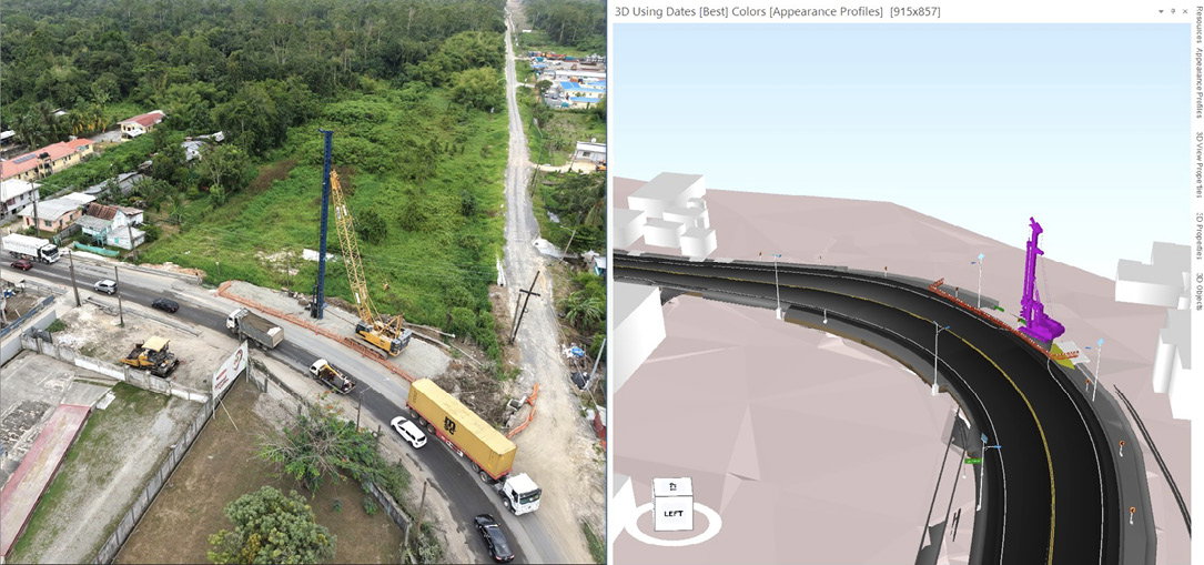
In Guyana, BIM already has begun making its way into public infrastructure delivery. The Ministry of Public Works included BIM requirements from the bidding stage in the design and build procurement of one of the main road projects in the capital, Georgetown—a significant step for a country that’s simultaneously scaling up its construction capacity and redefining how infrastructure is planned and delivered. It’s precisely in this environment—fast-paced, resource-constrained and rapidly evolving—that the practical limits of standard BIM workflows begin to show.
Within the BIM framework, 4D modeling takes coordination a step further. By linking the 3D model to the construction program, teams can simulate the entire construction sequence before a single piece of equipment moves to site. This adds the dimension of time to the digital model, making it possible to identify not just spatial conflicts, but sequencing problems such as detecting whether a planned detour would interfere with a drainage structure that’s still in operation or whether two work fronts are scheduled to converge at the same point at the same time.
For buildings and vertical structures, this approach works well. The simulation is concentrated in a relatively small geographic area, and the construction sequence can be observed clearly at any zoom level. Road projects are a different story. When your project stretches across 23 kilometers of varied terrain, passing through communities, crossing drainage systems and running alongside existing traffic; a single 4D simulation of the full corridor quickly becomes too broad to be useful. This article describes how that limitation led to a more focused methodology built around a simple but effective concept: concentrating 4D modeling resources where construction complexity is highest, which is defined as the Construction Complexity Index (CCI).
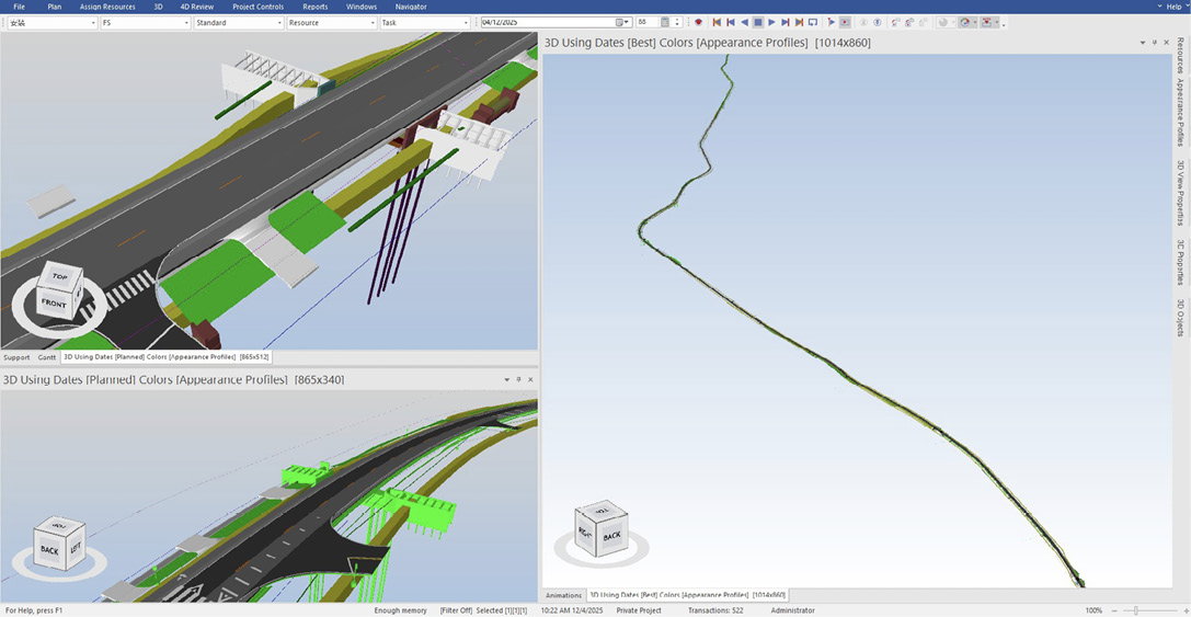
The full corridor of the Section B model at max zoom out in Synchro 4D Pro.
The Challenge
Linear infrastructure projects present a challenge that’s easy to underestimate: scale. Unlike a building, where floors stack vertically within a compact footprint, a road project spreads horizontally across kilometers of terrain, with multiple work fronts advancing simultaneously in different directions and conditions. Standard 4D modeling workflows weren’t designed with this in mind.
In the Georgetown road project—23 kilometers divided into three sections (8.7 kilometers, 10 kilometers and 5 kilometers)—BIM was a mandatory requirement of the general contract. The project team developed the BIM Execution Plan (BEP), built the 3D coordination models, and prepared the 4D simulation following the standard approach: linking the Work Breakdown Structure (WBS) to the construction program and the 3D model.
The result wasn’t what the team expected.
To capture the full 23-kilometer corridor in a single simulation, the model had to be zoomed out so far that individual work sequences became impossible to read. Activities that should’ve been clearly visible—excavation fronts, drainage works, pavement layers, etc.—blurred into an indistinct timeline with no practical value for the construction team. The model was technically complete. It satisfied the contractual requirement. But it was not telling anyone anything useful.
This created a real dilemma: should the team invest significant effort in preparing detailed 4D simulations for every work zone across the full 23 kilometers—a task that would stretch BIM resources to their limit—or accept the initial model as a contractual checkbox and move on? Neither option was satisfying. There had to be a smarter way.
The Solution
The answer wasn’t to abandon the full-corridor model—it had already served its contractual purpose. The real question was how to extract genuine value from 4D modeling within the resources available.
The approach that emerged was straightforward: stop trying to simulate everything in detail and instead focus the effort where it matters most.
Step 1. Review the full corridor, section by section
Working together, the BIM engineers and construction managers went through the entire project lane by lane, overlaying the 3D model with reality-capture data gathered from the project zone. This combination—the design model alongside the actual site conditions—gave the team a clear picture of where the construction sequence was straightforward and where complications were likely to arise.
Each section defined in the WBS was reviewed and assigned a CCI score: a percentage reflecting the expected construction difficulty of that section. Factors considered included access restrictions, proximity to existing services, drainage complexity, traffic-management requirements and tight sequencing among work fronts. Critically, the construction managers were an essential part of this evaluation—their field experience provided context that no model alone could capture.
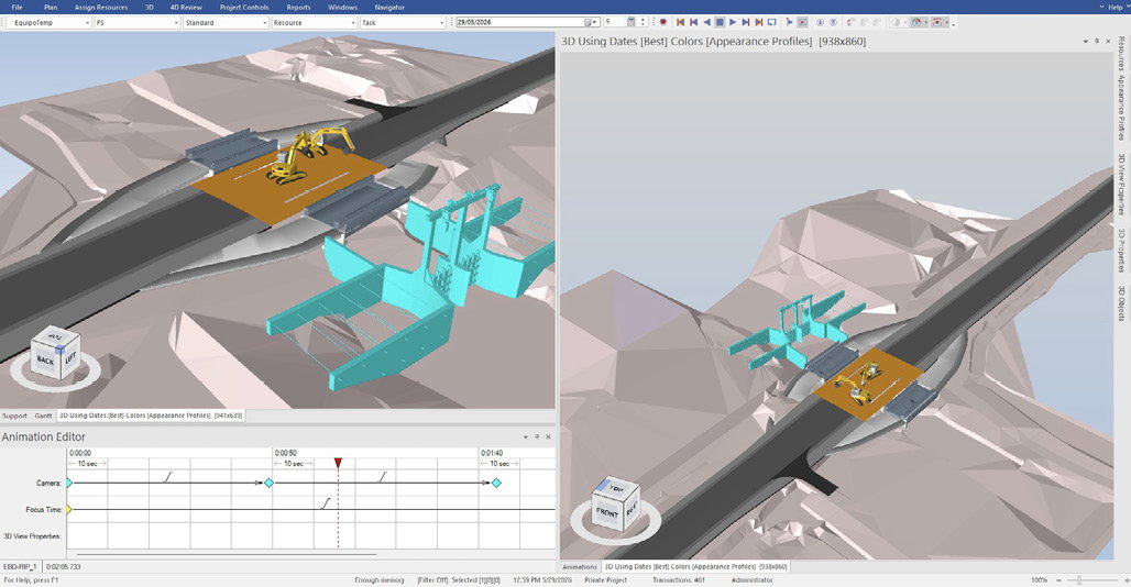
A focused 4D model of the BC-3 structure in Synchro 4D Pro.
Step 2. Define the threshold for detailed 4D modeling
After all sections had been scored, a project-specific threshold was established: any section with a CCI of 50 percent or above would receive a dedicated and detailed 4D simulation. Sections below that threshold were covered by the general model already in place.
This threshold isn’t a fixed rule; it can be adjusted based on the resources available and the level of BIM detail required by the contract. For this project, 50 percent represented the correct balance between coverage and efficiency.
This meant the BIM team was no longer trying to produce detailed simulations for every 300 to 400 meters of a 23-kilometer road. Instead, their effort was concentrated on the sections where a detailed simulation could actually change a decision, prevent a delay or resolve a conflict before it reached the site.
The Synchro 4D Pro model shows the BC-3 spatial conflict between an existing and temporary infrastructure.
Step 3. Prepare the focused 4D models
For each section exceeding the CCI threshold, a specific 4D simulation was prepared in Synchro 4D Pro, linking the detailed construction sequence to the 3D model of that particular stretch. The result was a set of targeted simulations: precise, readable and directly useful for the construction team.
The Results
The immediate benefit of this approach was efficiency: the BIM team and construction managers could concentrate their time and resources on the sections that genuinely needed detailed scrutiny, rather than spreading effort thinly across the full 23-kilometer corridor. But the real value of the methodology revealed itself during the review of one of those critical sections.
Case Study: Structure BC-3
Like most drainage structures along the corridor, BC-3 was initially planned to follow the standard reconstruction sequence: build a temporary detour, demolish the existing structure, construct the new one and then complete the water control works. On a 2D drawing, this sequence looked reasonable, and it was successfully applied to the other structures along the road. There was no obvious reason to treat BC-3 differently.
The 4D model told a different story.
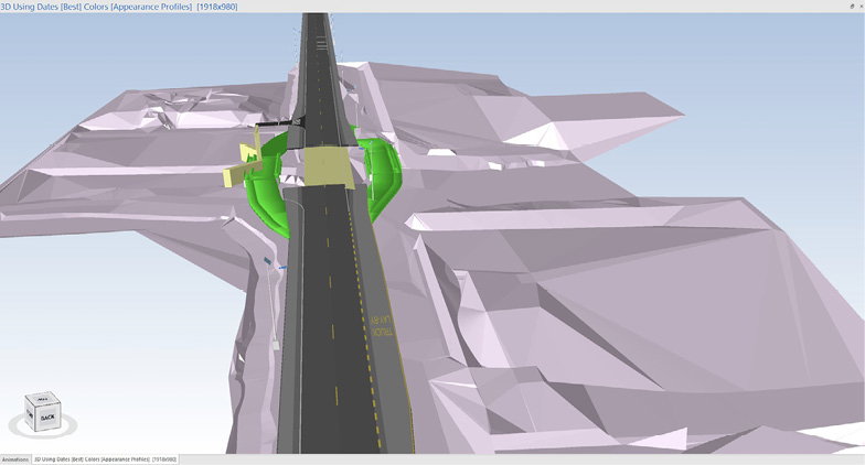
When the simulation was run for this specific section, a critical spatial conflict became immediately visible: the eastern side of the planned detour was too close to the existing water-control sluice. In practice, there wasn’t enough space for both the detour and the sluice to operate at the same time. A conflict that was invisible on a 2D drawing—and that could easily have been missed until equipment was already onsite—was caught clearly in the simulation.
The solution was straightforward after the problem was identified. The construction sequence for BC-3 was revised: instead of starting with the detour, the team would first construct the new water-control sluice at its final location, then demolish the old one, and only then proceed with the detour and structure replacement. A simple change in order, but one that prevented what could have been a costly disruption to both the construction program and the existing water-control system.
This is precisely the type of outcome that justifies the focused 4D modeling approach. Not a theoretical benefit, but a real conflict caught before it reached the site.
Lessons Learned
Construction projects always are constrained by time and resources—that’s not a new problem. What this experience reinforced is that the key isn’t having more resources, but knowing where to concentrate the ones you have. The focused 4D modeling approach applied in this project is a direct response to that reality: stop trying to cover everything equally and invest your effort where the construction is most likely to run into trouble.
The BC-3 case wasn’t exceptional; it was predictable. The real lesson is that similar conflicts exist in most road projects. The question is whether the team has the methodology to find them before construction begins.
That said, there are two things that would be done differently next time:
1. Incorporate clash-detection results into the feasibility review.
When scoring sections for construction difficulty, the team relied primarily on visual review of the 3D model and site conditions. In hindsight, the clash-detection analysis—particularly conflicts among existing structures, temporary works and new construction—should’ve been an explicit input into that scoring process. Some constraints aren’t immediately visible during a walkthrough of the model but show up clearly in a clash report. Combining both sources of information would produce a more complete and reliable prioritization.
2. Follow the construction program, not the chainage order.
The initial review and model submission requests were organized from north to south, essentially from the start of the project to the end. It seemed logical at the time. However, the construction program established different start dates for different sections and chainages, meaning some areas further along the corridor were scheduled to begin work earlier than sections closer to the start. A more-efficient approach would’ve been to align the 4D model review sequence with the construction program from the beginning, prioritizing the sections that were going to be built first, regardless of their position along the corridor.
Industry Value
The challenge described in this article isn’t unique to Guyana. BIM teams worldwide—particularly in developing countries and regions where infrastructure investment is accelerating faster than BIM capacity—regularly face the same tension: contractual BIM requirements on one side; and limited personnel, software licenses and time on the other.
The focused 4D modeling approach presented here offers a practical response to that tension. By introducing the CCI—a structured evaluation of each project section based on construction difficulty, site constraints and direct input from the construction team—BIM managers can make informed decisions about where detailed 4D simulations will add the most value and where the general model is sufficient.
The threshold doesn’t have to be fixed at 50 percent. When resources are more abundant, a BIM manager may choose to prepare detailed simulations for all sections scoring 30 or above. When resources are tighter, the threshold moves up. The CCI gives the team a transparent and defensible basis for those decisions—one that can be communicated clearly to the client, contractor and project owner.
This flexibility is especially important for how BEPs are written for linear infrastructure projects. A BEP that requires detailed 4D modeling for every work zone or chainage interval without accounting for project scale, resource availability or construction complexity is setting the team up for a checkbox exercise—exactly the situation this project started with. BEPs for road and linear infrastructure projects should explicitly allow for a CCI-based approach, defining the methodology for prioritization rather than mandating uniform coverage across the full corridor.
For developing countries entering the BIM space, this is a particularly relevant consideration. The goal isn’t to apply 4D models everywhere at all times; it’s to apply it where it
makes a difference.
A video version of the BC-3 structure can be watched here.
Elvis Rojas-Pereyra
Elvis Rojas-Pereyra, MSc., is a civil engineer and BIM expert, Sheladia Associates Inc.; email: [email protected].
Video: New Roundabout Under Construction at McIver and Old Florence Roads in Darlington County

Promenade at The Point

June Issue 2026
.jpg?width=225)