
Amanda Jones
In an industry where precision is measured in fractions of an inch and safety is nonnegotiable, Amanda Jones isn't just following the rules—she’s rewriting the workflow.
As a licensed land surveyor and founder of AJ Surveying Inc., Jones has spent more than two decades navigating the high-stakes world of California’s infrastructure. Her recent pivot toward AI-powered innovation has positioned her as a trailblazer in a field often tied to tradition. Based in San Diego, her woman-owned firm has become a recognized leader, specializing in high-precision boundary resolution and topographic mapping essential to the state’s most complex utility projects.
Trusting an Instinct: The Search for a Better Way
Jones first encountered the potential for AI-powered data capture during a project review with a partner engineering team. For a firm rated A with ISNetworld and maintaining a zero-incident safety record, the interest wasn't simply new technology—it was safety and reliability.
“We are always looking for technology that lets us work smarter without compromising precision or safety,” Jones said. “I was looking for a ground-based solution that could handle the complexity of our urban and utility environments without the restrictions of a drone.”
The Proof of Concept: The Bridge Challenge
The team’s journey with handheld photogrammetry began with a bridge clearance survey, a task that traditionally requires extensive man-hours and hazardous traffic management. Jones chose this as the test case for the Looq platform, an AI-powered handheld system.
The results were immediate. Using the handheld sensor, the team captured the necessary data in less than 10 minutes, achieving accuracy within ±0.05 feet. What used to take a full crew several hours became a CAD-ready deliverable in less than a day.
“The platform even flagged an error in data collected with our legacy equipment during those early tests,” Jones said. “What started as a faster tool quickly became a validation mechanism that strengthened our confidence in our total data quality.”
Scaling Up: Burying California’s Grid
With the bridge project proving the technology’s accuracy, Jones moved to a larger stage: California’s utility undergrounding program. Tasked with delivering precise topographic data over hundreds of miles to help mitigate wildfire threats, the scale was unprecedented.
Traditional surveying methods, while reliable, often fall short when faced with the scale and urgency of these projects. UAVs can accelerate data capture, but strict flight restrictions near airports and densely populated urban areas limit their usefulness. Jones’s firm used the handheld system to walk these linear corridors, capturing dense topographic data on foot.
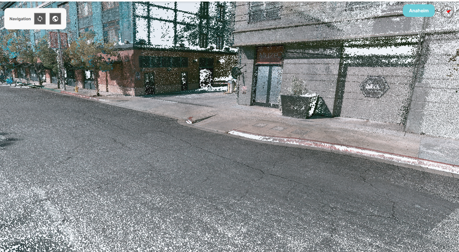
High-density reality capture collected with Looq AI and processed by AJ Surveying to document buildings, utilities, roadways and existing site conditions. (Credit: AJ Surveying)
The results transformed the firm’s efficiency:
• Eight times faster capture: Urban city blocks that required large amounts of detailed data were completed in a fraction of the time.
• 43% reduction in costs: Streamlined field operations allowed junior staff to handle captures, freeing senior surveyors for complex analysis.
• One platform: Jones eliminated the need for four to six different software programs, consolidating the workflow into a single system.
A Partnership of Expertise
Dominique Meyer, CEO and co-founder of Looq AI, said Amanda’s role was more than that of a customer.
“Amanda provided vital feedback during the early days of our system development,” Meyer said. “We aren't here to disrupt traditional surveying—we’re here to augment it. Having a veteran PLS like Amanda push the limits of the technology ensured the AI delivered what surveyors actually need in the field. She didn't just adopt the tool; she helped shape it.”
-21-(2).jpg)
Field technician capturing high-density reality data with the Looq platform to support accurate, efficient documentation of infrastructure and existing site conditions. (Credit: Looq AI).
Looking Ahead
For Amanda Jones, adopting AI wasn’t about the novelty of the technology—it was a business necessity. By bridging the gap between traditional land surveying and modern AI, AJ Surveying has redefined how quickly a firm can move without losing its footing.
“It’s changed how we scale, how we deliver and how we compete,” Jones said. “In environments where every measurement matters, having a tool that makes us this agile is a game-changer.”

Christine Byrne
Christine Byrne is Director of Corporate Communications at Looq AI; email: [email protected].
Video: New Roundabout Under Construction at McIver and Old Florence Roads in Darlington County

Promenade at The Point

June Issue 2026
.jpg?width=225)