
Immersal Oy launches Immersal City-Scale Visual Positioning System
The new 5G-enabled smart city Visual Positioning System offers unmatched accuracy and new business opportunities for mobile network operators and their customers (Helsinki, Finland & Barcelona, Spain) Immersal Oy, part of Hexagon, announced today at Mobile World Congress (MWC) in Barcelona, Spain, the launch of Immersal City-Scale, a Visual Positioning System (VPS). This innovative solution offers unmatched accuracy in outdoor location-based services for mobile network operators and their ent...
Article Sheds Light on the Power of Geocells in Load Support Applications
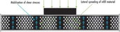
Geocells are one of the most valuable tools in the civil engineering and construction industries today. When constructing roadways over soft soils and weak subgrades, geocells can make a significant impact. However, some engineers may be uncertain about using geocells due to a lack of understanding. A recent article aims to clear up any confusion and show the power of geocells in load support applications. The article focuses on the concept of lateral confinement and how it relates to hoop st...
Teledyne’s New Ladybug6 Camera for High-Accuracy 360-Degree Spherical Image Capture Now Shipping
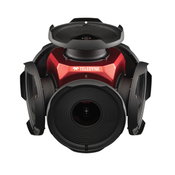
Richmond, CANADA - Teledyne FLIR is pleased to announce its all new Ladybug6 360-degree camera is now in full production. “We are excited to announce that our newest Ladybug camera is in production now and units are shipping immediately. The interest expressed by so many of our long-term customers has been astounding with order commitments made months in advance,” said Mike Lee, Senior Product Manager at Teledyne FLIR. “For applications that require high accuracy imaging like high-definition...
DuPont Consolidates Ultrafiltration Technologies Under New IntegraTec™ Brand
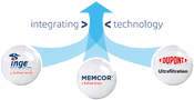
To better serve municipal and industrial customers, DuPont is consolidating and rebranding its diverse portfolio of ultrafiltration (UF) membranes for the sustainable purification, conservation and reuse of water. The DuPont™ IntegraTec™ portfolio of ultrafiltration technologies and products consolidates several legacy ultrafiltration brands– from Inge®, Memcor®, and DuPont Ultrafiltration – into a singular portfolio available to customers. This new offering makes it easier for DuPont’s cu...
Leica Geosystems announces performance upgrades for airborne deep bathymetric surveys
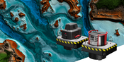
The new Leica HawkEye-5 bathymetric LiDAR sensor provides a significant improvement in flight efficiency for detailed data capture in deep waters (Heerbrugg, Switzerland) — Leica Geosystems, part of Hexagon, announced today the release of the Leica HawkEye-5, the new highly efficient airborne bathymetric LiDAR solution for deep water surveying. The upgraded technology increases survey efficiency by up to 25% compared to previous generations. The Leica HawkEye-5 expands the capabilities o...
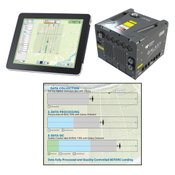
Teledyne Geospatial revolutionizes airborne lidar ROI with Galaxy Onboard: a real-time workflow solution
Vaughan, Ontario, CANADA – Teledyne Geospatial announced the release of the Galaxy Onboard, a workflow-focused solution that enables airborne surveyors to deliver quality-controlled processed data in real time. With Galaxy Onboard, Teledyne Geospatial has lowered the barrier of entry for organizations venturing into airborne mapping with a solution that does not require expertise or months of training. Galaxy Onboard will also offer exceptional value to airborne surveyors allowing them to exp...

StormTrap’s New Stormwater Treatment Device, StormSettler, Receives New Jersey Department of Environmental Protection Certification Under Latest Protocol
StormSettler, developed by StormTrap, is a highly efficient stormwater treatment settling device that improves the quality of stormwater runoff. ROMEOVILLE, Ill.- StormTrap® announced today the release of the new stormwater treatment device, StormSettler™. The patent-pending treatment device, designed to remove sediment from stormwater runoff, has received New Jersey Corporation for Advanced Technology (NJCAT) verification and NJDEP Certification for online and offline use after...
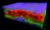
Golden Software Adds Powerful New 3D Subsurface Visualization Functionality to Surfer® Surface Mapping Package
Interpolate and visualize 3D data, such as subsurface soil or groundwater contamination, mineralization concentration, seismic refraction velocity, temperature distribution, or dissolved oxygen concentration. GOLDEN, Colorado – Golden Software’s Surfer package, long known as the geoscience profession’s most powerful 3D surface mapping software, now provides robust subsurface visualization and modeling functionality. In the latest Surfer release – available today – Golden Software has inc...

Esri Releases New ArcGIS Reality Software to Capture the World in 3D
ArcGIS Reality Enables Site, City, and Country-wide 3D Mapping for Digital Twins REDLANDS, Calif.— Business, government, and science organizations increasingly rely on drones, crewed aircraft, and satellites to capture imagery. Detailed imagery data provides visibility into operations and opportunities, unpacking information from every pixel and transforming static pictures into dynamic digital representations of the world. 3D models and high-resolution maps of construction sites, compl...

BAAM.Tech Named North American Reseller for AISPECO’s Next-Generation Infrastructure Inspection Platform
Lenexa, Kansas – BAAM.Tech®, headquartered in Lenexa, Kansas, is pleased to announce that it has executed an agreement with AISPECO from Vilnius, Lithuania to become their North American hardware reseller. BAAM.Tech® will assume sales, training, and technical support services for AISPECO’s Pod – a customizable, multi-vehicle LiDAR and imaging payload solution that is compatible with many FAA-approved aircraft mounts. This system is designed to support quick installation and sensor configurati...
Video: New Roundabout Under Construction at McIver and Old Florence Roads in Darlington County

Promenade at The Point

June Issue 2026
.jpg?width=225)