
Presto Geosystems Announces Environmental Product Declaration for Geocells
With the commercialization of geocell soil confinement technology in the early 1980s, Presto Geosystems made history as one of the early pioneers in the world of geosynthetics. Over four decades later, that innovative spirit is as alive today as it was at the beginning of our journey. Presto Geosystems, the leader in geocell technology, announces the publication of the industry´s first Environmental Product Declaration (EPD) for geocells. This milestone reinforces Presto Geosystems’ ongoing comm...

PIX4Dcatch is an integral component of Topcon’s newest handheld scanning solution, the CR-H1, designed for accurate reality capture
Lausanne, April 15, 2025 Pix4D is a core technology collaborator in the newly launched CR-H1 handheld reality capture solution from Topcon Positioning Systems. Pix4D continues to advance its RTK-supported technologies with PIX4Dcatch, now offering compatibility with the latest GNSS receiver from Topcon Positioning Systems—the CR-H1. This collaboration reflects Pix4D’s commitment to supporting developments from its collaborators, delivering solutions that prioritize accuracy and precise georef...

DuPont Water Solutions Launches WAVE PRO for Ultrafiltration Modeling
Most comprehensive web-based modeling tool for ultrafiltration water treatment processes DuPont Water Solutions recently launched WAVE PRO, a powerful online modeling tool for a variety of ultrafiltration (UF) water treatment applications – including drinking water, industrial utility water, wastewater, and seawater desalination. This next generation of the Water Application Value Engine (WAVE), WAVE PRO for UF guides water professionals through the water treatment design process for...

SE Careers launches the first national career site specifically for Structural Engineers
Holland, Mich.: SECareers is proud to announce the launch of the first national job and career site dedicated to Structural Engineers and Engineering Firms. SE Careers was created with the purpose of effectively finding structural career opportunities that better meet the specific skills and interests of structural engineers. SE Careers offers a suite of services, including: Job postings with specific, searchable, structural engineering and company attributes to make finding matches fas...

Bentley Systems Partners with Google to Improve Infrastructure Through Asset Analytics
An example of how Bentley’s Blyncsy technology can be used with Google Street View imagery to detect roadway issues and assets, from potholes and crosswalk paint condition to street signs and traffic lights. (Photo: Bentley Systems) Bentley will leverage high-quality Google imagery and AI for faster, more efficient roadway inspections and damage assessment LAS VEGAS, April 9, 2025 – (Google Cloud Next 2025) – Bentley Systems, Incorporated (Nasdaq: BSY), the infrastructure enginee...

Topcon 3D leveling system now compatible with new Dynapac Highway Paver series
MUNICH — Topcon Positioning Systems has announced that its MC-Max Asphalt paving system has been confirmed compatible with the Dynapac SD25 and XD25 Highway Paver series, enabling automatic control of height, steering, and screed width for enhanced paving precision and efficiency. Following successful testing, Dynapac has issued formal confirmation of the integration’s effectiveness. This development streamlines the implementation of Topcon advanced machine control technology for Dynapac paver o...
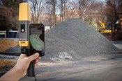
Topcon launches CR-H1 handheld reality capture solution for maximum mobility
MUNICH — Topcon Positioning Systems has announced the CR-H1, a handheld solution that represents one of the latest additions to the company’s Capture Reality portfolio of mass data solutions. The system utilizes PIX4Dcatch, a specialized application that runs on iPhone devices with integrated LiDAR that collects images and employs photogrammetry to create detailed, full-color 3D point clouds. The iPhone connects to Topcon’s HiPer CR receiver, enabling the application to collect georeferenced ima...

Topcon introduces solutions for 3D mass data workflows
MUNICH — Topcon Positioning Systems has announced new technology solutions for 3D mass data workflows. Enhancements to the Topcon Collage Site software solution provide new workflow capabilities designed to allow for the real-time acquisition and processing of data more accurately, efficiently, and quickly to provide the user with greater productivity. Collage Site software allows a single operator to scan, process, and view complete georeferenced point clouds in real time while still in the...

Trimble and Liebherr Introduce Trimble Ready Factory Option for Liebherr PR 776 Generation 8 Bulldozers
Alexander Katrycz, Head of Marketing at Liebherr-Werk Telfs GmbH (left) and Scott Crozier, Vice President, Civil Construction Field Systems at Trimble (right) at bauma 2025 event. (PRNewsfoto/Trimble) TELFS, Austria and WESTMINSTER, Colo., April 7, 2025- Trimble® (Nasdaq: TRMB) and Liebherr announced the introduction of a Trimble Ready® factory option for the new line of Liebherr PR 776 Generation 8 bulldozers, the latest model from Liebherr's competitive dozer lineup to featur...

Esri Helps Bring Up-to-Date Road Closure Information To Consumer Mapping Apps
ArcGIS Users Can Provide Road Closure Data to Apple Maps and TomTom to Help Improve Travel for Motorists REDLANDS, Calif. — Esri, the global leader in GIS technology and location intelligence, has enhanced its popular Community Maps Program to make sharing of road closures much easier with the Road Closures solution. This new solution in Esri’s ArcGIS, the leading and most comprehensive geospatial platform, bridges the gap between government agencies managing timely road updates and the publi...
Video: New Roundabout Under Construction at McIver and Old Florence Roads in Darlington County

Promenade at The Point

June Issue 2026
.jpg?width=225)