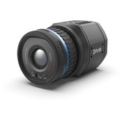
FLIR Launches its First Uncooled, Fixed-Mount, Connected Thermal Camera for Detecting Methane: GF77a
FLIR GF77a Offers Low-Cost Optical Gas Imaging Solution for Continuous and Autonomous Leak Detection ARLINGTON, Va.– FLIR Systems, Inc. (NASDAQ: FLIR) announced today the FLIR GF77a Gas Find IR camera, its first fixed-mount, uncooled, autonomous leak detection camera designed specifically to visualize methane and other industrial gases. A new camera in FLIR Systems’ optical gas imaging (OGI) series, the connected GF77a provides upstream and midstream gas processors, producers, and operators w...
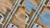
Virtual Surveyor Streamlines Volumetric Calculations for Stormwater Retention Ponds, Basins & Quarries
AARSCHOT, Belgium – Virtual Surveyor has released Version 7.1 of its popular drone surveying software, introducing functionality to efficiently calculate volumetrics in quarries, mine pits, retention ponds, and other basins that fill with water. This new functionality complements advanced cut-and-fill mapping capabilities unveiled in late 2019. “Virtual Surveyor is now the go-to package for managers of mines, drainage pits, and stormwater retention basins,” said Tom Op ‘t Eyndt, CEO of Virtua...

GeoBase Team Wins AFIMSC Team of the Year Award
The AFCEC GIO team is comprised of more than 50 geospatial professionals, most of whom work at Woolpert. JOINT BASE SAN ANTONIO-LACKLAND, Texas — The Air Force Civil Engineer Center (AFCEC) Geospatial Integration Office (GIO) GeoBase team was honored this month with the Air Force Installation and Mission Support Center (AFIMSC) Team of the Year Award. GeoBase is the U.S. Air Force Installation Geospatial Information and Services Program. The team comprises more than 50 geospatial professi...

KOREC and NCTech launch KlearView360°
Companies join forces on vehicle-based visual asset inspection and verification system Liverpool & Edinburgh, UK – KOREC and NCTech today announced the launch of KlearView360°, a streamlined, hosted system designed for the identification of assets, defects or changes within images collected by vehicle or backpack. A cost-effective solution, KlearView360° makes vehicle-mounted asset inspection accessible to local authorities and many others. The system is a joint partnership between the tw...

Enscape Introduces Version 2.7 of its Real-Time Rendering Software
New BIM-driven Workflows and Enhanced Performance Make Enscape the Perfect Complement to the Building Design Process Karlsruhe, Germany — Enscape, the leading provider of real-time rendering and visualization technology to the global Architectural, Engineering, and Construction (AEC) market, announces the version of Enscape 2.7. This newest version brings improved performance, quality enhancements, and new BIM-driven workflows. “Enhancing BIM workflows and improving usability are the majo...
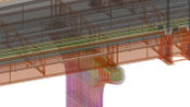
HDR Selected to Bring PennDOT’s Vision of 3D-Only Plans to Reality
OMAHA, Neb. — The Pennsylvania Department of Transportation has selected HDR to assist it in developing and implementing its 3D Digital Delivery initiative. The game-changing effort will redefine how infrastructure projects are designed and delivered in the state. Through 3D Digital Delivery, the department expects that by 2025 all of its construction projects will have the ability to be bid using 3D technology such as building information modeling, rather than in a traditional construction p...

Leica Geosystems announces new most accurate total station
Leica Nova TS60 minimises costs and downtime with sub-second and sub-millimetre accuracy, newly integrated DynamicLock and AutoHeight features. Heerbrugg, Switzerland – Leica Geosystems, part of Hexagon, announced today the new Leica Nova TS60, the world’s most accurate total station, with newly integrated DynamicLock and AutoHeight features. The new version of theTS60 total station is now equipped with DynamicLock, allowing the instrument to lock onto a moving prism, and devised with...

Leica Geosystems Brings the World’s First MultiStation to the Next Level
The new version of Leica Nova MS60 enables users to perform all surveying tasks with one instrument (Heerbrugg, Switzerland, 18 February 2020) – Leica Geosystems, part of Hexagon, announced today the new Leica Nova MS60. The MS60 MultiStation, brings sensor fusion to the next level by combining upgraded faster 3D laser scanning capabilities, GNSS connectivity and digital imaging with a highest-end total station. The new MS60 features several laser scanning updates, including an incredib...

Utilities need to exploit the deluge of data set to grow in 2020 as smart device sales soar, reveals GlobalData
Big data analytics has emerged in response to the exponential growth in data and the utility industry, like most other industries, has started to make several transformations with the use of modern devices, says GlobalData, a leading data and analytics company. Cloud computing, machine learning, Internet of Things (IoT), robotics, blockchain and cybersecurity are being deployed by utilities in their operations. These technologies are the big current and future investment avenues for utilities...

Eka Reports 25% Increase in Energy Clients on its Cloud Platform
Germany: Eka Software Solutions, leading global provider of commodity management solutions, announces at E- World Energy and Water 2020 today a significant increase in energy customers in 2019, driven largely by its cloud platform. This growth reflects a seismic shift in the commodity industry as energy businesses move to a more digitized, cloud-based enterprise platform to manage their trading, risk and supply chain operations. As energy markets continue to grow more complex and volatile,...
Video: New Roundabout Under Construction at McIver and Old Florence Roads in Darlington County

Promenade at The Point

June Issue 2026
.jpg?width=225)