AEC from Home: Tips from Leading Professionals Adjusting to Work During the COVID-19 Pandemic
In May 2020, Informed Infrastructure Editorial Director Todd Danielson interviewed three leaders of AEC firms to learn how they’re adjusting to the “new normal” and help pass along some of the tips and lessons learned from their experiences in early 2020.
Collaboration in Product Development Results in Better Designs
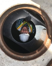
Good design is slow. Effective collaboration also takes time. According to Sara Pevaroff Schuh, the founding principal of Philadelphia-based SALT Design Studio, “Quality fights to be a full partner at the table with quick.” She’s right. It may seem like an all-too-costly endeavor to return to the drawing board, but the familiar cliche rings true: you either pay now or pay later. Green City, Clean Waters Rob Woodman, senior stormwater engineer at ACF Environmental, witnessed firsthand th...
Bridging the Divide: How Lidar Data Help Mitigate Landslides Near Yellowstone
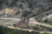
The Double Draw Landslide in May 2011 closed U.S. 26 for about a month after leaving an estimated 200,000 tons of debris on the highway. More landslides occur along a 38-mile region of U.S. 26/287 in northwest Wyoming—close to Yellowstone National Park and along the Continental Divide—than any other stretch of roadway in the state. The instability is attributed to the topography, weather and proximity to Yellowstone, which sits atop an active volcano and contains more than half of...
Signed, Sealed, Delivered: A Growing Trend Toward 3D Digital Deliverables for Bridges and Structures
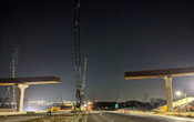
In the United States, a project-delivery revolution that’s been building for years is unfolding. As software continues to “eat the world,” Model Based Design and Construction (MBDC) has been slowly and methodically added to the menu. MBDC is the use and transfer of digital data and information among design and construction to convey design intent, capture as-constructed data, and provide data for asset management. MBDC, including the use of 3D models as legal contract documents, is being d...
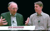
The CEO Series Continues: Excerpts from an Interview with Esri President Jack Dangermond: The Convergence of AEC and GIS
In November 2019, Informed Infrastructure Editorial Director Todd Danielson interviewed Esri President Jack Dangermond at the Autodesk University (AU) Conference in Las Vegas. The full interview video (above) also can be viewed at bit.ly/2VTPr4q, but we wanted to include some excerpts in this issue. Danielson: Tell me about the partnership between Esri and Autodesk. Dangermond: Several years ago, Autodesk executives and myself got together, and we thought we should re...

Interview with Esri President Jack Dangermond
In November 2019, Informed Infrastructure Editorial Director Todd Danielson interviewed Esri President Jack Dangermond at the Autodesk University (AU) Conference in Las Vegas.

ARTBA Chairman Steve McGough Makes Case for Infrastructure Package with Trump Administration
WASHINGTON — American Road & Transportation Builders Association (ARTBA) Steve McGough April 29 called on the Trump administration and Congress to take immediate steps to stabilize state transportation programs and enact a multi-year plan that dramatically increases federal highway, bridge and public transportation investment. McGough, the president and CFO of Houston-based HCSS, delivered his remarks during a U.S. DOT virtual "listening session" led by Secretary Elaine Chao, Federal Highway...
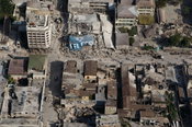
Ten Years After the Haiti Earthquake: How Building Disaster-Resilient Structures Can Lift a Nation
Image: Port-au-Prince, Haiti, suffered massive destruction from an earthquake in 2010. By Kit Miyamoto, Ph.D., S.E., and Lucienne Cross In 20 years of responding to earthquakes as a structural engineer, I have never seen destruction such as I witnessed in Haiti a decade ago. Traveling through the wreckage of Port-au-Prince just days after the earthquake of Jan. 12, 2010, I saw a hellish landscape: people digging through concrete for missing family, twisted metal, cars squashe...
Deliberate Clashing in Urban Infill Projects
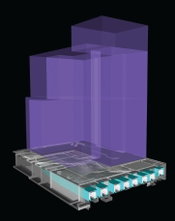
A partial 3D axonometric section shows the representation of an existing railyard with a structural platform built around it as well as the potential massing of a building above. All geometry was created within either AutoCAD or Revit and then imported into Navisworks. As urban populations grow and demand for housing increases, vacant or underutilized land is at a premium, leading to a rise in urban infill projects. Whenever the needs of a dense population change drastically in a shor...
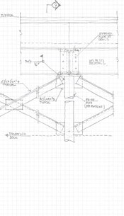
It’s the Thought That Counts: Simple Tools (Like Hand Sketches) Can Help Create Better Designs
Publisher’s Note: I met structural engineer Clark Baurer when I served as a juror for the Structural Engineers Association of Illinois’ (SEAOI) Excellence in Structural Engineering Awards Competition—his elegant and innovative structural renovation of Chicago’s Theater on the Lake won the Lavicka Award for Small Firm/Small Project up to $2 million. The project hit a sweet spot for me: repurposing an old structure as well as a complicated structural challenge. Clark’s use of hand drawings was an...
Video: New Roundabout Under Construction at McIver and Old Florence Roads in Darlington County

Promenade at The Point

June Issue 2026
.jpg?width=225)