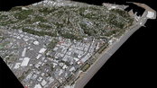
iXblue, Woolpert Partner to Deliver Lidar Mapping Services to New Zealand Councils
BRISBANE, Australia — Woolpert and iXblue Sea Operations division, part of the French-based iXblue Group, have been awarded two significant airborne lidar mapping projects in New Zealand, covering over 38,500 square kilometres for the Hawke’s Bay and Waikato regional and local councils. These projects are part of the New Zealand government’s Provincial Growth Fund Lidar program in which the Ministry of Business, Innovation and Employment, Land Information New Zealand and councils are working...

Parsons Adds Resilience to Wildfire Mitigation and Utility Infrastructure Protection
Grid Armor™ empowers utility companies with predictive analytics CENTREVILLE, Va., – Parsons Corporation (NYSE:PSN) today announced Grid Armor™, a predictive resiliency solution that helps utility companies improve operational efficiency and better respond to and prevent potential catastrophic events, such as wildfires and major power outages. Using artificial intelligence and machine learning, Grid Armor™ collects real-time data from weather, conductors, video and vegetation and provides sim...
Burns & McDonnell Keeps Workforce Moving Through Pandemic
Firm Completes World Headquarters Campus and Continues Work on Nearly 10,000 Critical Infrastructure Projects KANSAS CITY, Missouri — State and local leaders joined Burns & McDonnell to dedicate the opening of the final building on its world headquarters campus to those who worked on its front lines — the critical infrastructure workers. Since breaking ground in 2018 on the $42 million project, crews worked more than 134,000 hours without any safety incidents — even through the height of th...

Doosan Bobcat Partners with Ainstein to Develop Radar Sensor Technology for Compact Equipment
Strategic partnership will leverage state-of-the-art technology for autonomous operations WEST FARGO, N.D –Doosan Bobcat North America announced today it has partnered withAinstein AI, Inc., a radar technologies company headquartered in Lawrence, Kan., to develop next-generation radar sensor systems for Bobcat® equipment. Through this partnership, Ainstein and Doosan Bobcat North America will collaborate to create radar-based sensing solutions to detect objects and people on job sites. “Th...

Stantec supports Harvard study that shows incorporating natural elements indoors reduces stress and improves creativity
Edmonton, AB; Detroit, MI (June 11, 2020) TSX, NYSE: STN Stantec, a leading global design firm, continues to drive innovation at the forefront of workplace design by contributing to company-sponsored biophilic design research through the Healthy Building Program at the Harvard T.H. Chan School of Public Health. Biophilic design is a strategic approach to incorporate nature into the built environment. The research shows that biophilic design can improve holistic wellness and key cognitive functi...

Report: Cost and length of North American construction disputes increased in 2019
Highlands Ranch, Colo. — A report released today by Arcadis reveals that the volume and value of construction disputes in North America increased for the first time since 2013, while the average time taken to resolve these disputes also increased in 2019. The data for this report was gathered prior to the COVID-19 pandemic, and how the industry collaboratively responds to the many challenges that flow from the pandemic will play a large role in the quantity, duration and value of constructio...

America’s Engineering Businesses Welcome House Surface Reauthorization Bill
Urge Swift Action on an Infrastructure-Based Recovery Agenda Washington, DC – With today’s release of the House Democrats’ surface transportation reauthorization package, the American Council of Engineering Companies – the voice of the America’s engineering businesses – is urging lawmakers on both sides of the aisle to come together and expedite passage of an infrastructure-based recovery agenda. “Today is just the beginning of the conversation in the House, but we are one step closer...

BYD Institutes Stringent SafetyProtocolsas it Reopens Electric Vehicle Manufacturing Plant in California
LOS ANGELES - BYD (Build Your Dreams), a leading manufacturer of zero-emission vehicles and a major employer in Los Angeles County, announced it has implemented stringent safety protocols and begun a phased reopening of its Lancaster Coach and Bus manufacturing plant. As it reopens, BYD will continue to follow guidelines for safe operations set by California, Los Angeles County, and the City of Lancaster while ramping up production of all-electric transit buses and motor coaches that meet str...
Bentley Systems Announces the Acquisition of NoteVault, Provider of Voice-based Field Automation for Construction Management
Advancing the Scope of Construction Digital Twins EXTON, Pa. – Bentley Systems, Incorporated, a leading global provider of comprehensive software and digital twins services for advancing the design, construction, and operations of infrastructure, today announced the acquisition of NoteVault, a San Diego-based provider of voice-based field automation for construction management. The acquisition expands Bentley’s SYNCHRO digital construction environment with industry-leading mobile field...

ForneyVault® Partners with Quadrel on Concrete Management Software Integration
Martin Marietta, Inc., Is First to Use Pittsburgh, PA: ForneyVault®, an integrated construction materials testing platform, recently added Quadrel, LLC, to its growing list of software integration partners. The interface allows Quadrel’s customers to have easy access to ForneyVault along with its own technologies for concrete and aggregate management. Martin Marietta, Inc., in Denver, CO, is the first Quadrel customer to use the integrated materials testing platform with concrete cylinde...
Video: New Roundabout Under Construction at McIver and Old Florence Roads in Darlington County

Promenade at The Point

June Issue 2026
.jpg?width=225)