/ Category / data

Autodesk Construction Cloud Introduces New Data Sharing Capabilities to Transform Construction Collaboration

April 4, 2022 - in News, Products, Technology

With Bridge, construction teams now have more control and flexibility when sharing project information with different stakeholders San Francisco, Calif. – Autodesk, Inc. (NASDAQ: ADSK) today launched Bridge, a new collaboration capability that…

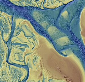
Quantum Spatial Completes Data Collection for NOAA’s Largest Coastal Mapping Project

October 22, 2020 - in Land Development, News, Technology

Unique Combination of Sensors Used to Gather High Resolution Topographic and Bathymetric Lidar Data Along 12,000 Square Miles of Eastern Seaboard and…

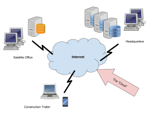
Use the Cloud to ‘Make It Rain’

February 14, 2017 - in Articles, Feature, Featured

By Mark Scacco, P.E. Hybrid cloud solutions provide immediate access to project data regardless of internet connectivity Unless you’ve been hiding under…

Video: Greg Bentley Interview Part 1: Favorite Projects and BIM Advancements

January 12, 2017 - in Interview, Videos

Informed Infrastructure interviewed Greg Bentley, the CEO of Bentley Systems, at the Year In Infrastructure Event held Nov. 1-3, 2017, at the Hilton London Metropole. In Part 1 of this interview, he discusses some of his favorite finalists and winners from…

FHWA Concludes MAP-21 Truck Size and Weight Limits Study

May 2, 2016 - in Analysis, Corporate, Transportation

The Federal Highway Administration's truck size and weight limits study was delivered to Congress April 14, concluding more than three years of work on a report that was required by the 2012 MAP-21 surface transportation bill. The issue of truck size and weight…

LandWorks, Inc. Partners with USLandGrid

April 18, 2016 - in Corporate, Modeling, Surveying/Mapping

HOUSTON, TEXAS, April 18, 2016 – LandWorks Inc., a developer of innovative land management and related GIS software, announced its reseller partnership with USLandGrid, a provider of high-resolution vector data. LandWorks’ core business is providing land…

PennSMART Brings IoT Lighting Systems and Streetscapes to Smart Cities, Municipalities and Campuses

March 14, 2016 - in Corporate, Design/Engineering

NORTH BRANFORD, CONN., March 14, 2016—When your light pole can scare away an intruder, capture video of a perpetrator, measure snowfall to trigger the arrival of snowplows, and support a range of other desirable functions, you can assume it came from PennSMART.…

Iowa DOT Joins Waze Connected Citizens Program

August 18, 2015 - in Corporate, Sensors, Transportation

AMES, Iowa, Aug. 17, 2015—With historic amounts of road construction happening on Iowa’s highways this summer, knowing where traffic is moving and where it is not can be critical to travelers. To increase the amount of real-time data available, the Iowa…

BTS’ National Transportation Statistics Updated

April 27, 2015 - in Corporate, Modeling, Transportation

Friday, April 24, 2015—The U.S. Department of Transportation’s Bureau of Transportation Statistics (BTS) today updated National Transportation Statistics (NTS)– a web-only reference guide to national-level transportation data. NTS, updated quarterly,…

New Data Show U.S. Drivers Topped 3 Trillion Miles Last Year

March 13, 2015 - in Corporate, Roads

WASHINGTON, March 12, 2015—New estimates released today by the U.S. Department of Transportation’s Federal Highway Administration (FHWA) show that Americans drove nearly 3.02 trillion miles in 2014, the highest point since 2007 and the second-highest since…