
Surveyors are accustomed to working with sophisticated and powerful technology, such as GNSS, laser scanning, and photo capture, which makes their jobs so much easier than it used to be. Even 30 years ago, gathering geometric data about the real world used…

Sponsored Content: Photo Capture: Another Big Leap for Survey Technology
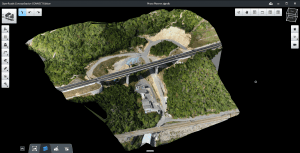
More Projects, Bigger Projects, Done More Frequently For land surveyors and other mapping and measurement professionals, photo capture of 3D environments…

ContextCapture Improves Quality of Reality Modeling Within Geospatial Workflows
Bentley Systems announces general access to the latest release of ContextCapture and ContextCapture Center. This release enhances the accessibility, scale,…

Reality Modeling for Everyone
Highly Accurate Context from Simple Photography Before beginning any infrastructure project, a project team needs to survey existing conditions in order to provide the foundational input to the decision-making process—to understand the context within which…
