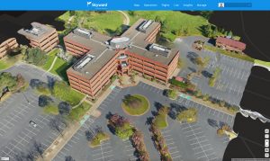
Skyward Mapping & Modeling, powered by Pix4D, enables customers to create, view, measure, and export 2D orthomosaic maps and 3D photogrammetric models right from Skyward’s web app PORTLAND, Ore. - Today, Skyward, A Verizon company, announced its…

Make a Steel Building Sail: BIM and VDC Bring Church of the Resurrection to Life
When people think of churches, what often comes to mind is a square white building with a triangular roof and a steeple on top. When the congregation…

Bluesky’s 3D Aerial Laser Maps Inform BIM Projects
Leicestershire, UK, June 9, 2016— – 3D models produced from aircraft mounted lasers are being used by survey company Greenhatch Group to help inform…

Autodesk ReMake Does Heavy Lifting of Reality Capture Mesh Models
The ability to digitize the physical world into high definition 3D models just took another leap forward. After a successful test period Autodesk ReMake, previously known as Autodesk Memento, is now available as a commercial product. ReMake converts a sequence…

Arithmetica Releases Pointfuse Software at Intergeo
Pointfuse, the automated point cloud processing software from Arithmetica, will be released as standalone software at Intergeo 2014. Offering a fast, precise, yet flexible way of converting laser scanner point clouds into highly accurate vector models, Pointfuse…
Bentley Releases LEAP Bridge Steel for the Design, Analysis, and Load Rating of Steel Bridges
Bentley Systems, Incorporated, the leading company dedicated to providing comprehensive software solutions for sustaining infrastructure, today announced the immediate availability of LEAP Bridge Steel for the 3D modelling, design, analysis, and load rating…

Bentley Introduces Subsurface Utility Engineering (SUE) for Intelligent 3D Models for Underneath Construction Zones
Dealing with the infrastructure that can’t be seen, and that in some cities has been in the ground for 100 or more years, is a serious challenge that directly impacts project budgets. Users want a solution to accomplish good space management and good workflows…

Agency9 CityPlanner Adds Support for Blom3D
Agency9, the leading provider of web based 3D visualisation and GIS solutions, announces support in its CityPlannerOnline for the extensive archive of 3D models from Blom, a leading European service provider within acquisition, processing and modelling of…