Michigan Department of Environment, Great Lakes and Energy, Water Resources Division
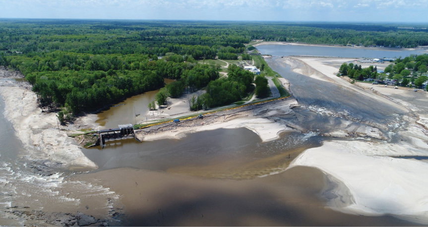
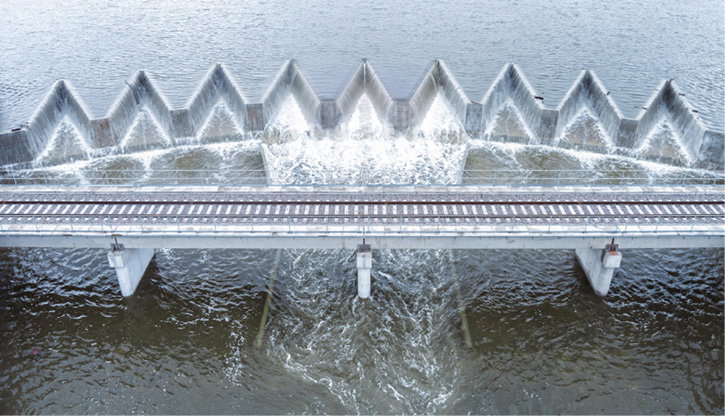
The Tobacco River was diverted when the Edenville Dam spillway liquified and breached in 2020. The collapsed M-30 bridge is visible in the distance in the wider view.
On May 19, 2020, a sandy section of the Edenville Dam in Edenville, Mich., underwent liquefaction following heavy rains, allowing the previously impounded Wixom Lake to breach the dam. The failure released a flood that then overtopped the downstream Sanford Dam, which subsequently failed about three hours later. While prudent planning and a conservative decision to evacuate prevented any loss of life, the dam failures caused some $200 million in property damage.
Had inspections revealed the stability vulnerability within Edenville, affordable remediations could likely have avoided the disaster, according to an Association of State Dam Safety Officials (ASDSO) case study (https://iimag.link/EScgk).
Concerns Across the Country
Nationwide, ASDSO sounded the alarm on the number of hazardous dams in need of repair. With worsening climate change, aging dams are facing new weather extremes just as expanding urban development places more people and structures in the path of potential failures. These circumstances are pushing safety engineers to do more with less money and potentially leverage new technologies.
While the number of dams in the country with “high-hazard” potential numbered 9,525 in 2005, that number has grown more than 40 percent to 13,421 in 2023, according to ASDSO. A measure of the loss of human life and property that a dam failure or misoperation would cause, the high-hazard category now includes more dams as more people move into potential flood-inundation zones.
Bill McCormick, a past ASDSO president and former chief of the dam safety branch of the Colorado Division of Water Resources, said many dams have experienced “hazard creep.” Although they were designed and built in rural areas where the consequences of failure were relatively minor—a loss of crops, perhaps—the dams get kicked into a higher hazard category if the downstream land changes hands, subdivisions are built and the potential for loss of life increases while the dams themselves remain the same.
“(Hazard creep) describes why we’re increasing the number of high-hazard dams without increasing the total number of dams very much,” explains McCormick. “These older dams now go from low or significant hazard to high hazard.”
Oftentimes, the agency approving a new housing development doesn’t own the dam, leaving the owner to handle the new requirements for engineering, operations, maintenance and monitoring with little say and no financial assistance.
“There are maybe some solutions that are happening in different parts of the country, but it’s an area that’s been a problem for sure,” says McCormick.
Meanwhile, the dams are aging. A national ASDSO report (iimag.link/FJXSR) highlighted an increase in the proportion of high-hazard dams in need of repair, growing from 6 percent in 2005 to 19 percent in 2024. The organization ranked 2,434 high-hazard U.S. dams as in poor or unsatisfactory condition in 2023. And with repair needs tied to the age of the dams, the report expects that number to climb.
The Federal Emergency Management Agency (FEMA) National Inventory of Dams estimates the country’s 92,591 dams now average 65 years old.
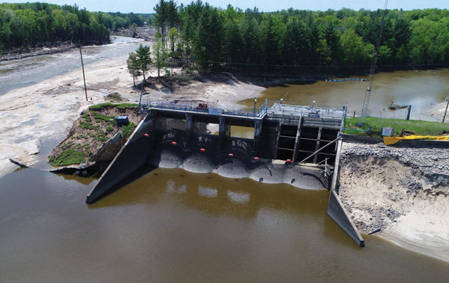
The Sanford Dam failed about three hours after the upstream Edenville Dam breached. (Michigan Department of Environment, Great Lakes and Energy, Water Resources Division)
A Lack of Funding
The American Society of Civil Engineers (ASCE), in its “2025 Report Card for America’s Infrastructure,” graded dams a D+, identifying a need for some $185 billion in funding between 2024 and 2033 for a system set to receive only $20 billion. Non-federal high-hazard dams alone need an estimated $37.4 billion for repairs.
“Without a more-significant commitment to dam safety through increased annual investment in inspection, monitoring, planning and necessary dam repairs, the cost to bring the nation’s dams into a state of good repair will continue to rise, and downstream communities will face a greater risk of danger from potential dam failure,” writes the report’s authors.
The ASCE report went on to flag dam safety programs receiving annual appropriations below their authorized federal funding levels. For example, only a portion of the funding provided by the Infrastructure Investment and Jobs Act for FEMA’s National Dam Safety Program and the High Hazard Potential Dam (HHPD) Rehabilitation Grant Program will actually reach those programs, as Congress and the U.S. Department of Homeland Security redirected those funds in 2024. The HHPD Grant Program received no federal funding in fiscal years 2023 and 2025.
“Failure to fund the HHPD Grant Program diminishes the purchasing power of these investments, resulting in insufficient resources to support state program needs such as hiring qualified engineers to conduct dam inspection and monitoring,” writes the report’s authors.
Help From Space
A team of researchers at Virginia Polytechnic Institute and State University thinks there may be ways to better prioritize the limited funding available. Using satellite images of 41 hydropower dams taken between 2015 and 2025, the team was able to flag dam deformations at a fraction of the cost of ground-based inspections.
“We are looking from a global scale at different dams at the same time, and we can figure out, ‘Hey, these five (dams) sound like they have some issues; let’s go and see. Put them in priority among the limited observations that are in the field,’” says Virginia Tech Geoscientist Mohammad Khorrami, Ph.D.
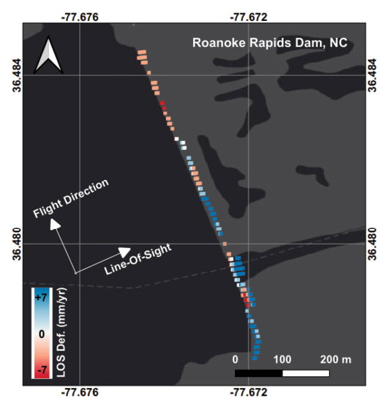
Satellite scans reveal areas of subsidence within the Roanoke Rapids Dam in North Carolina, seen in red. As a high-hazard dam, a failure would likely cause loss of human life. (Mohammad Khorrami)
Specifically, the team analyzed images taken by the Interferometric Synthetic Aperture Radar aboard the Sentinel-1 satellite constellation. Launched by the European Space Agency in 2014 and 2016, the constellation’s two satellites orbit 180 degrees apart and compare the phase and amplitude shifts between their measurements to create high-resolution elevation maps of Earth’s land surface. They’re capable of delivering images through all weather conditions, day or night. The system has aided applications ranging from Arctic sea-ice monitoring to emergency disaster response to climate studies.
“It cut the cost by a lot,” says Manoochehr Shirzaei, Ph.D., associate professor of geophysics and remote sensing at Virginia Tech. “It’s an order of magnitude cheaper, and then it has higher spatial resolution. We can monitor the entire dam and collect sometimes hundreds—maybe thousands—of observation points on the dam.”
Shirzaei stressed that the satellite images can’t yet replace in-situ observations. Traditional tools such as extensometers, distributed acoustic sensing and point-wise measurements offer a temporal resolution, sometimes measuring every fraction of a second, currently unmatched by satellites, which take days to revisit a site.
Other newer technologies also look to provide automated dam monitoring with the idea of raising flags when they detect something anomalous. Automated data-acquisition systems can collect readings from electronic instruments, such as vibrating wire piezometers, and feed cloud-based monitoring systems.
“If the change in readings over a certain frequency is greater than what you would expect, it sends an alarm to somebody,” notes McCormick. “Then you would send a person out to the dam to put eyes on it themselves to see what’s going on.”
In this context, satellites can excel at conducting low-cost, large-scale studies that create a baseline diagnosis for many dams and call for further measurements when observations deviate from that baseline, according to the Virginia Tech researchers.
“Think about it as a healthcare system for dams,” adds Shirzaei. “You go first to your general physician, you do an examination, and if there is nothing serious, you never go to the specialist.”
The industry has also focused on forensic studies of past dam failures, gleaning hard-won lessons to better inform future dams.
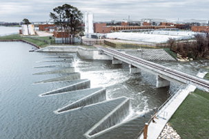
The rehabilitation of Bachman Lake Dam in Dallas, led by design and engineering firm Stantec, was completed in March 2026, ensuring the structure’s safety and regulatory compliance. The 125-year-old dam underwent hazard creep after growth and development transformed the once low-density area outside the city into residential and light-industrial uses.(Stantec)
Checking the Weather
Limited funding also has hampered dam infrastructure in ways beyond inspection budgets.
Beginning in the 1940s, the National Weather Service (NWS), at the request of and with the funding of other agencies, issued hydrometeorological reports that provided guidance on a meteorological concept known as probable maximum precipitation (PMP). PMP describes the greatest amount of precipitation, within a given duration and at a particular time of year, that a design watershed or storm area can expect to receive.
“In a nutshell, those reports would look back at historical, large storms and do a bit of work called maximization and transposition,” explains McCormick. “They would take a storm that happened some place else, (and) they would move it to a location where a new dam was being built. They put that over the watershed, and then they maximize it.”
When combined with an area’s hydrology, PMP yields another value known as probable maximum flood (PMF), which engineers then use to tailor project aspects, such as dam heights, reservoir capacities and flood-carrying capacities, so the project can safely pass a theoretical maximum flood.
Funding for PMP guidance, however, gradually diminished to zero through the years, with NWS issuing its last hydrometeorological report, describing PMP for California, in 1999.
Climatic Effects
PMP also makes no allowance for long-term climatic trends. Because the deterministic PMP methodology relies on actual past storms, and because the lack of funding has created a void of reports during the warmest years on record, the decades-old reports now offer questionable guidance.
“The problem with that in a changing climate is, as you probably know, the past is not necessarily a good predictor of the future,” adds McCormick.
In 2014, ASDSO partnered with NOAA to pass the Weather Forecasting Improvement Act, giving NOAA a legislative mandate to modernize PMP. With funding from the Bipartisan Infrastructure Law in 2021, a team was spun up and modernization work began. But the current White House administration has cut NOAA and NWS funding once again, stymying progress.
“ASDSO and the dam-safety industry as a whole is pretty hopeful that they were on the right track to modernize these PMP methods, and we’re still pushing for that,” says McCormick. “But it might be a little longer off than what we had originally thought.”
The agencies hope to apply modern engineering techniques and science-based methods to predict rainfall in a given watershed under today’s climatic conditions. If the work finds that past dam capabilities fail to meet the new weather criteria, the group will begin the cycle of searching for funding to increase the capacity of spillways.
“We’re trying to get answers for those things, so we can give dam owners and engineers the right tools to be able to make modifications to dams where needed,” notes McCormick.
On Sept. 10, 2023, Storm Daniel caused a massive flood in Libya that washed away the 140-foot-high Abu Mansour Dam and the 80-foot-high Al Bilad Dam, inundating the city of Derna below and killing thousands of people.
While the region’s political instability prevented recommended rehabilitation projects, Shirzaei said the dams’ engineers simply didn’t have that level of precipitation in mind when they built the dams in the 1970s. The extreme storm dropped on the city almost 16 inches of rain in 24 hours, exceeding the area’s annual rainfall of some years and representing a return period of 1,000 years.
“Even if it would have been inspected and would have been kept in the best condition, in my opinion, it would not have been a match for that flood,” Shirzaei says of the dam. “That flood would have overtopped that dam anyway.”
The changing climate has complicated dam safety in other ways, too. While heavier rains may bring floods in excess of past PMFs, longer droughts can also wreak havoc on the structures.
“When a dam is dry (and) the reservoir is empty, it’s exposed to dehydration,” explains Shirzaei. “That is proven to compound the impact of the flood that happens in a wet year. Dams that were exposed to sun for too long a period of time are more susceptible to failure than dams that routinely had water.”
As the planet warms, the atmosphere evaporates surface water faster and stores a greater amount of that water. As a result, droughts last longer and are punctuated by heavier precipitation events.
“We need to re-examine all the infrastructure of dams and levees from the perspective of climate change—not only wet climates, but also dry climates,” says Shirzaei.
The Other Side of the Equation
While engineers work to minimize the probability of failure, McCormick notes that dam owners, municipalities and emergency managers are simultaneously working to mitigate the consequences of failure.
FEMA’s Dam Safety Program, for example, has worked to prepare owners and downstream communities for emergencies by teaching them to recognize precursors to dam failures, create emergency action plans and conduct exercises.

The ESA’s Sentinel-1 constellation, with one satellite seen here above Italy, uses advanced radar technology for continuous, all-weather, day-and-night imaging of Earth’s surface. Researchers believe the technology can be used to flag dams in need of closer inspection. (ESA/Mlabspace)
The Virginia Tech team hopes to combine future satellite data with hazard data to connect communities with the risks they live with. An interactive map and risk calculator, available to the public and policymakers, could share their dynamic risk models to better inform decisions.
During the 2020 Edenville event, Michigan’s Midland County Emergency Management, the agency managing emergency response below the Edenville Dam, called for an evacuation a full 18 hours before the dam failure.
Because of the management team’s work, it had already identified the dam’s failure as a worst-case scenario during planning exercises. Multiple agencies had already practiced their emergency response plans, and, during the storm, their communications system effectively messaged the community when needed, safely evacuating some 10,000 people with no loss of life.

David Jen
David Jen is a freelance science journalist based in the San Francisco Bay Area. Learn more about him at www.davidjen.com or follow him on Twitter @djenwrites.
Video: New Roundabout Under Construction at McIver and Old Florence Roads in Darlington County

Froedtert Hospital Expansion

June Issue 2026
.jpg?width=225)