Аutomatic Vertical Scanning for Drones Now Available
SPH Engineering has introduced the Facade scan tool for UgCS, the world’s premier provider of mission planning software for unmanned aircraft systems (UAS).
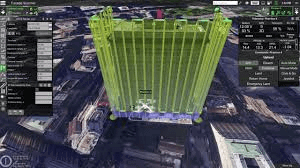
The tool allows the drone operator to draw a vertical plane, and to specify the distance to the wall, as well as side and forward overlap. The optimal flying path is then calculated automatically. UgCS supports the import of 3D objects and custom DEM data using the terrain-following function.
The tool is also extremely useful in mining, making it possible to examine open quarries. Drone inspections are not only a cost-saving measure for mining companies, they also save humans from having to do the most dangerous work. Drones can be used to survey even unstable pits from a safe distance, and the data gathered will be much more accurate compared to other methods that don’t involve workers climbing down the pit. As mines can often change due to work and natural conditions, repeated drone inspections can bring data up-to-date in a fast and convenient way.
Please find attached more detailed information in the PressRelease attached (.PDF and .DOCX format) and images of the UgCS facade scan tool.
The UgCS Facade scan tool in action video: https://youtu.be/Ww37vR5dli4
Author

Parul Dubey
Video: New Roundabout Under Construction at McIver and Old Florence Roads in Darlington County

K2b Cantonal Highway

June Issue 2026
.jpg?width=225)