
Esri Adds California Live Camera Feeds to ArcGIS for Better Awareness of Wildfires and Other Disasters
New Map Layer Provides Critical Real-Time Information to Emergency Responders and the Public REDLANDS, Calif.—Esri, the global leader in location intelligence, and the University of California San Diego’s ALERTCalifornia program have launched a new ready-to-use map layer that provides instant access to live camera feeds across California. This collaboration comes at a critical time, as the state faces increasingly frequent and severe natural disasters, particularly wildfires, that threaten p...

Bentley Systems Partners with Google to Improve Infrastructure Through Asset Analytics
An example of how Bentley’s Blyncsy technology can be used with Google Street View imagery to detect roadway issues and assets, from potholes and crosswalk paint condition to street signs and traffic lights. (Photo: Bentley Systems) Bentley will leverage high-quality Google imagery and AI for faster, more efficient roadway inspections and damage assessment LAS VEGAS, April 9, 2025 – (Google Cloud Next 2025) – Bentley Systems, Incorporated (Nasdaq: BSY), the infrastructure enginee...
Woolpert Partners with Teren to Further Expand its Geospatial Services to Global Energy Customers
The combined industry-leading lidar capabilities and software solutions will help mitigate risk to critical pipeline and utility infrastructure. DENVER — Woolpert, a premier architecture, engineering, and geospatial (AEG) firm, announced today that it has forged a strategic partnership with Teren, a leader in AI-powered, lidar-enabled environmental intelligence capabilities. This collaboration will advance the collection and application of lidar data for oil and gas infrastructure, providing...
Topcon launches CR-H1 handheld reality capture solution for maximum mobility
MUNICH — Topcon Positioning Systems has announced the CR-H1, a handheld solution that represents one of the latest additions to the company’s Capture Reality portfolio of mass data solutions. The system utilizes PIX4Dcatch, a specialized application that runs on iPhone devices with integrated LiDAR that collects images and employs photogrammetry to create detailed, full-color 3D point clouds. The iPhone connects to Topcon’s HiPer CR receiver, enabling the application to collect georeferenced ima...
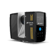
Topcon introduces solutions for 3D mass data workflows
MUNICH — Topcon Positioning Systems has announced new technology solutions for 3D mass data workflows. Enhancements to the Topcon Collage Site software solution provide new workflow capabilities designed to allow for the real-time acquisition and processing of data more accurately, efficiently, and quickly to provide the user with greater productivity. Collage Site software allows a single operator to scan, process, and view complete georeferenced point clouds in real time while still in the...

Lisa Thompson Named National Business Growth Director for WSP Advisory and Planning
Collaborates with clients and colleagues across the firm’s U.S. business to develop and secure opportunities that advance communities. ATLANTA — As transportation, environment and infrastructure organizations navigate increasingly complex challenges, Lisa Thompson, joins WSP in the U.S. as senior vice president, Advisory and Planning business development director. Thompson, a member of the firm’s U.S. Advisory and Planning senior leadership team, develops and maintains key client rela...

ACI Foundation Announces New Council Chairs
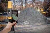
Farmington Hills, MI – April 9, 2025: New chairs have been announced for the ACI Foundation’s Concrete Innovation Council, Concrete Research Council, and Scholarship Council. Lesley S.C. Ko, chair of the Concrete Innovation Council. Ko serves as the Director for Cementitious and Sustainable Materials at Structural Technologies LLC, a part of Structural Group Inc. that is the largest concrete repair and maintenance provider in the US. Previously, she held a manager position for Product Develop...

Pix4D and Prostar Partner to Provide Precision 3D Augmented Reality of Critical Underground Infrastructure Worldwide
Lausanne, April 9, 2025 — Pix4D, a global leader in photogrammetry and 3D mapping technology, and ProStar Holdings Inc. (“ProStar®”) (TSXV: MAPS) (OTCQX: MAPPF) (FSE: 5D00), a leading provider of Precision Mapping Solutions®, announce a strategic partnership. This collaboration combines Pix4D’s advanced 3D modeling capabilities with ProStar’s PointMan® platform to support the next evolution in augmented reality for critical underground infrastructure. Pix4D and PointMan represent a significan...
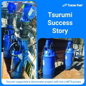
Tsurumi Pump Delivers Reliable Dewatering Solution for Critical Stormwater Infrastructure Project
When a contractor faced the challenge of dewatering a stormwater shaft, having the right equipment was essential. Tsurumi provided two LH875 high head dewatering pumps as an immediate solution, ensuring that the project could continue moving forward. When a stormwater tunnel retention system required urgent rehabilitation, efficient dewatering was critical to keep a contractor’s project on schedule. Faced with a 150-foot-deep access shaft and a tight project timeline, the contractor turned to...

CRTS Global Acquires RAE Energy’s Coatings Business
Bryan Kirchmer, President at CRTS. Image Courtesy: CRTS Dubai, United Arab Emirates - CRTS Global LLC (CRTS) has announced its acquisition of RAE Energy’s coatings business (RAE Coatings), an investment that significantly enhances CRTS’ leadership in the global pipeline coatings market. The acquisition positions CRTS as the only provider that delivers complete internal and external pipeline field joint coating solutions for the offshore sector. CRTS, a portfolio company of Voyager Inte...
Video: Crashes Drop Measurably After Rural Road Safety Improvement Project on US 521 in Lancaster County

AdventHealth Weaverville Hospital

June Issue 2026
.jpg?width=225)