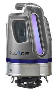
Brand-New Optech Polaris Terrestrial Laser Scanner Launches at INTERGEO 2016
Teledyne Optech is pleased to announce the release of its new Optech Polaris TLS Series of tripod-mounted laser scanners, which bridge the gap between small short-range scanners and heavier long-range scanners. Over three years in development, the Polaris is a sensor designed by surveyors for surveyors, based on Teledyne Optech’s decades of lidar experience. Launching with three distinct models at separate price points and a multitude of options and features, the Polaris promises to bring Tel...
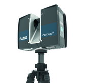
FARO Launches the FocusS Laser Scanner with IP54 Rating and In-Field Compensation for Construction BIM-CIM and Public Safety Forensics Professionals
LAKE MARY, Fla. - FARO® (NASDAQ: FARO), the world's most trusted source for 3D measurement and imaging solutions for factory metrology, product design, construction BIM/CIM, public safety forensics and 3D solutions and services applications, announces the release of the all-new FARO FocusS Laser Scanner. The FocusS is the newest member of FARO’s popular Focus Laser Scanner product line and is available in both 150m and 350m ranges. Designed for construction BIM-CIM and public safety forensics...

Teledyne Optech Unveils the Ultra-light Maverick for Mobile Asset Mapping
Teledyne Optech is excited to announce the release of its Maverick mobile mapping system. Light enough to be worn on a backpack, the Maverick sets a high bar for size, portability and versatility in mobile asset mapping. Weighing in at less than 9 kg, the Maverick integrates a lidar, a 360° camera, and an INS into an extremely small form factor that is easy to install, while maintaining the data quality that users expect from a Teledyne Optech system. Never has accurate, mobile asset data bee...
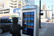
Washington, D.C., Digital Kiosks and Sensor Network to Harvest a Wealth of Urban Data Including CyberCity 3D Buildings and Maalka Software
Washington, DC -- At seven feet tall and featuring 55-inch screens, the 30 kiosks coming to downtown D.C. will be much more than glorified digital ad machines. Designed by New York–based Smart City Media, the kiosks will feature timely information relating to nearby restaurants, retail, events, and public transportation. This pilot program is led by private nonprofit DowntownDC Business Improvement District (BID), which is supported by the property owners within its 138-block area northeast of...
Bechtel Executive Appointed to President's Advisory Council On Doing Business In Africa
The U.S. Department of Commerce announced today that Bechtel executive, Andrew Patterson has been appointed to the President’s Advisory Council on Doing Business in Africa. Patterson serves as the company’s region president for business in Africa. Established in 2014, the council advises President Obama on enhancing commercial engagement between the United States and Africa through the involvement of senior private sector leaders representing a wide range of industry sectors. The announcement...
Trimble Expands 3D Laser Scanning Portfolio with Addition of New TX6 and Improved TX8
HAMBURG, Germany - Trimble (NASDAQ: TRMB) introduced today its new Trimble® TX6 and improved TX8 high-performance 3D laser scanning solutions. With a fully integrated High Dynamic Range (HDR) camera and Wi-Fi remote control, the high-speed 3D laser scanners provide increased productivity and versatility for users. The TX6 and the TX8 leverage Trimble's patented technology, combining microsecond time-of-flight distance measurement with advanced on-board signal and 3D data processing, designed to...

DroneDeploy Launches Drone Service Provider Directory to Help Businesses Ramp Drone Operations
SAN FRANCISCO, CA - DroneDeploy, the leading cloud-based drone software platform, today unveiled the Drone Mapping Directory, a drone mapping marketplace to connect businesses with drone service providers. At launch, the Drone Mapping Directory unites more than 250 drone service providers operating in 48 countries and servicing 10 industry verticals. DroneDeploy also announced the launch of a co-branded offering, which enables companies to brand their DroneDeploy portal and maps. The emerging...
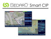
Sedaru Deploys Smart CIP, Advancing the Connected Utility, Empowering Integrated, Dynamic Asset Management for Water/Wastewater Systems
/ / / / ARCADIA, Calif. - IDModeling, Inc. the leading global provider of smart water software and services, announced today the deployment of Smart CIP™ for integrated, dynamic asset management of water & wastewater systems. Sedaru's Smart CIP technology provides a lightweight, sophisticated, enjoyable-to-use platform for utilities to connect their data, experience, and institutional knowledge to quantify and prioritize capital improvement projects (CIPs) to consistently measure and increas...
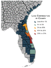
CoreLogic Analysis Shows Between $4 Billion and $6 Billion in Insured Property Loss from Hurricane Matthew
CoreLogic® (NYSE: CLGX), a leading global property information, analytics and data-enabled solutions provider, has conducted an analysis showing that insured property losses for both residential and commercial properties from Hurricane Matthew are estimated to be between $4 billion and $6 billion from wind and storm surge damage. This does not include insured losses related to additional flooding, business interruption or contents. Of this $4-6 billion, 90 percent of the insurance claims are exp...

TomTom’s HD Map Powers Autonomous Driving
MELBOURNE, Australia - ITS World Congress – TomTom (TOM2) today announces a joint autonomous driving demonstration with Bosch. TomTom provided its HD Map and RoadDNA technology to setup a demonstration on the Australian F1 Grand Prix circuit at Albert Park; these novel products are important components to enable Bosch’s demo vehicle to perform in autonomous driving mode. TomTom HD Map and RoadDNA are two revolutionary, highly accurate digital map based products helping automated vehicles precise...
Video: Habitat for Humanity - Women Build Event in Sacramento

AdventHealth Weaverville Hospital

June Issue 2026
.jpg?width=225)