

ARTBA.org Built for Association Members, Congressional Staff and News Media WASHINGTON – The American Road & Transportation Builders Association (ARTBA) has launched a redesigned flagship website to showcase how its members are using…
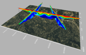
Latest Surfer® Mapping and 3D Visualization Package from Golden Software Gives Users Comprehensive View of Subsurface Data
Import imagery, such as PNG files of geophysical profiles, and position the images in any orientation! Import any georeferenced images, such as an aerial…
Trimble and DroneDeploy Introduce Premier Positioning Accuracy and Streamlined Workflow for Reality Capture from Drones
RTX-based cloud positioning service expands project opportunities for drone mapping DENVER – GEO WEEK (Booth# 1001) – Trimble (NASDAQ: TRMB)…

DJI Launches Its First Intelligent 3D Model Editing Software DJI Modify
Makes repairing common 3D model defects simple and efficient January 18, 2024 – DJI, the world’s leader in civil drones and creative camera technology, today introduced DJI Modify, the company’s first intelligent 3D model editing software.…

Trimble Introduces MX90 Mobile Mapping System
Trimble announced today the leading-edge Trimble® MX90 mobile mapping system. With state-of-the-art Trimble GNSS and inertial technology, when combined with Trimble field and office software, the Trimble MX90 provides a complete field-to-finish mobile…
Exyn Unveils Nexys: A Fully Modular 3D Mapping Solution for Complex and Challenging Environments
GEOWEEK, FEBRUARY – Exyn Technologies, a pioneer in autonomous robotics, today announced the launch of Exyn Nexys, a revolutionary modular 3D mapping solution. Designed for professionals in mining, construction, AEC, and geospatial industries, Nexys sets…

Autodesk Informed Design Unlocks Industrialized Construction to Connect Design and Make Workflows
Autodesk launches Autodesk Informed Design to unlock industrialized construction for building design professionals and manufacturers. Autodesk Informed Design connects design and make workflows from day one, to streamline the building design and construction…
New Esri UK partner Temple creates biodiversity net gain assessment tool
Streamlined workflow helps users meet England's new legislation Temple, one of the UK’s leading environment, planning and sustainability consultancies, has joined the Esri UK partner network as a Silver Partner. The new partnership enables Temple…
FleetWatcher Introduces Small Tools and Attachment Tracking Functionality
(Indianapolis, IN) – FleetWatcher introduces the newest telematics functionality for their popular construction telematics platform – Small Tools and Attachment Tracking. With a glance at their FleetWatcher User App, users can search for an individual…

Precisely Launches PSYTE™ US Geodemographic Data, Enabling Businesses to Reach Their Ideal Audience
PSYTE™ US geodemographic data offers easy-to-understand classification of populations across the U.S. Image depicts an overview of the different lifestyle segments present in an area of San Francisco. (Photo: Business Wire) January 17, 2024 BURLINGTON,…
