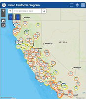
Caltrans Launches Digital Map Highlighting More than 300 Clean California Projects Transforming Communities Across the State
Interactive features allow users to locate, view, and learn more about beautification efforts SACRAMENTO – Just ahead of national infrastructure week, Caltrans today launched a new interactive map that spotlights hundreds of beautification projects funded by Clean California. The geographic information system (GIS) mapping tool offers users location-specific, multilayered data that demonstrates the transformative impact these community-focused improvements and infrastructure investments ar...

Esri Releases Latest Land Cover Map with Updated Sentinel-2 Satellite Data
Annual 10-Meter 2017–2023 High-Resolution Maps Available in Esri’s ArcGIS Living Atlas of the World REDLANDS, Calif. —Esri, the global leader in location intelligence, in its partnership with Impact Observatory, has released an updated global land-use/land-cover map of the world based on the most up-to-date 10-meter Sentinel-2 satellite data. In the update, the Sentinel-2 10m Land Use/Land Cover Time Series includes new data from 2023, expanding the series to include global coverage from 2017...

Autodesk Unveils Research Project Bernini for Generative AI 3D Shape Creation
Project Bernini is a research effort focused on developing generative AI for Design and Make industries. The first experimental Bernini model quickly generates functional 3D shapes from a variety of inputs including 2D images, text, voxels and point clouds. While Project Bernini is exciting and at the leading edge of generative AI, its models will become increasingly useful and compelling when trained on larger, higher-quality professional datasets. For the Design and Make industri...

New SUBE Bridging Connector From Simpson Strong-Tie Delivers Faster, Simpler End-of-Wall Bracing
Simpson Strong-Tie, the leader in engineered structural connectors and building solutions, is introducing the SUBE bridging connector for cold-formed steel. The wall-stud bridging connector is designed to connect cold-rolled channel at the end of a wall or single-stud jamb condition, or at the ends of panel walls, curtain walls or load-bearing conditions. The result is faster and simplified bracing with less buildup. SUBE connects to the open face of the stud, installing with two screws to t...
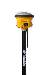
Trimble Introduces New Features for R780 GNSS Smart Antenna for Construction
Trimble has introduced a new version of the R780 GNSS Smart Antenna for construction site positioning. The following features now come standard with the R780: A dual-band radio (450 / 900 MHz) that connects to diverse base stations and job sites without the expense of additional external radios. The dual Trimble Maxwell™ 7 GNSS ASIC chip that enables greater performance in challenging GNSS environments (blocked sky, multi-path, or degraded signal) and provides more channels for future...

From wastewater to water features, Tsurumi’s VANCS™ pumps lead the way
VANCS Series pumps are known for their durability, versatility, and flawless performance in demanding applications. Made from heavy-duty materials, they can tackle challenging jobs in residential, commercial, industrial, and various wastewater settings. Whether handling wastewater with abrasive particles at a factory, dealing with oily fluids in a busy commercial kitchen, or simply supplying water in beautiful water features, Tsurumi Pump’s VANCS Series submersible resin pumps have gained a...

Polyglass Launches ModifleeceTM – A Fleeceback SBS (Elastomeric) Base Sheet
Polyglass U.S.A., Inc., a leading manufacturer of building envelope and waterproofing solutions, proudly announces the launch of ModifleeceTM, a revolutionary fleece-backed Styrene-Butadiene-Styrene (SBS) modified bitumen roofing membrane base sheet. Designed for the use in multi-ply low-slope roofing systems, Modifleece sets a new standard in roofing technology, offering unparalleled performance and versatility. Through an innovative laminating process, Modifleece integrates a specially for...

Introducing the Composability Framework V1.1
Digital Twin Capabilities Periodic Table V1.1: advancing interoperability for digital twins BOSTON, MA – Today, Digital Twin Consortium® (DTC) announced Version 1.1 of the Digital Twin Capabilities Periodic Table (CPT), an architecture and technology agnostic requirements definition framework for organizations that want to design, develop, deploy, and operate digital twins based on use case capability requirements versus the features of technology solutions. The CPT follows a periodic table...
Leica Geosystems launches its first Machine Smart Antenna — the Leica iCON gps 120
Heerbrugg, Switzerland) Leica Geosystems, part of Hexagon, today announced the launch of Leica iCON gps 120 — a smart antenna designed to further empower construction professionals with scalable and flexible machine control solutions. The new Leica iCON 120 Machine Smart Antenna is integrated into the existing Leica MC1 solution platform. Thanks to its flexibility, scalability and modularity, it extends the machine control solution offering to more applications and machine types. Construction...

The Release of UgCS 5.0 is Setting New Standards in Drone Flight Planning
The most significant release of UgCS, the best and most powerful flight planning tool for drone pilots, has landed! SPH Engineering is proud to announce the release of UgCS 5.0, marking a major milestone in drone flight planning software evolution. The biggest UgCS update in years is bringing along a refreshed and more friendly user interface. New UgCS 5.0 is inspired by the professional drone pilot community’s feedback, allowing pilots to tackle complicated projects and fly with LiD...
Video: Crashes Drop Measurably After Rural Road Safety Improvement Project on US 521 in Lancaster County

AdventHealth Weaverville Hospital

June Issue 2026
.jpg?width=225)