Presto Geosystems Announces Environmental Product Declaration for Geocells
With the commercialization of geocell soil confinement technology in the early 1980s, Presto Geosystems made history as one of the early pioneers in the world of geosynthetics. Over four decades later, that innovative spirit is as alive today as it was at the beginning of our journey. Presto Geosystems, the leader in geocell technology, announces the publication of the industry´s first Environmental Product Declaration (EPD) for geocells. This milestone reinforces Presto Geosystems’ ongoing comm...

PIX4Dcatch is an integral component of Topcon’s newest handheld scanning solution, the CR-H1, designed for accurate reality capture
Lausanne, April 15, 2025 Pix4D is a core technology collaborator in the newly launched CR-H1 handheld reality capture solution from Topcon Positioning Systems. Pix4D continues to advance its RTK-supported technologies with PIX4Dcatch, now offering compatibility with the latest GNSS receiver from Topcon Positioning Systems—the CR-H1. This collaboration reflects Pix4D’s commitment to supporting developments from its collaborators, delivering solutions that prioritize accuracy and precise georef...
Introducing Blink by FARO® Technologies: Reality Capture Reimagined
Stunning Visuals, Automated Workflows and One Touch Insights LAKE MARY, Fla. (April 15, 2025) — FARO® Technologies, Inc. (Nasdaq: FARO) has announced the launch of a unique 3D reality capture solution, FARO Blink, marking an important milestone in its mission to streamline and democratize the process of 3D reality capture. A software-driven solution, Blink combines stunning visualization with automated workflows via the FARO Sphere® XG Digital Reality Platform, all while ensuring intuitive ope...
DuPont Water Solutions Launches WAVE PRO for Ultrafiltration Modeling
Most comprehensive web-based modeling tool for ultrafiltration water treatment processes DuPont Water Solutions recently launched WAVE PRO, a powerful online modeling tool for a variety of ultrafiltration (UF) water treatment applications – including drinking water, industrial utility water, wastewater, and seawater desalination. This next generation of the Water Application Value Engine (WAVE), WAVE PRO for UF guides water professionals through the water treatment design process for...

Aalberts integrated piping systems’ "Apollo"® backflow solutions: safeguarding water quality with sustainable protection
Backflow prevention solutions deliver advanced protection, compliance, and ease of maintenance for critical water systems Aalberts integrated piping systems (IPS), a global leader in advanced integrated piping systems for the distribution and control of liquids and gasses, highlights its "Apollo"® backflow product line, delivering superior protection against water contamination across a variety of applications. Designed to meet stringent safety standards, "Apollo"® backflow prevention solutio...

Esri Adds California Live Camera Feeds to ArcGIS for Better Awareness of Wildfires and Other Disasters
New Map Layer Provides Critical Real-Time Information to Emergency Responders and the Public REDLANDS, Calif.—Esri, the global leader in location intelligence, and the University of California San Diego’s ALERTCalifornia program have launched a new ready-to-use map layer that provides instant access to live camera feeds across California. This collaboration comes at a critical time, as the state faces increasingly frequent and severe natural disasters, particularly wildfires, that threaten p...

Topcon 3D leveling system now compatible with new Dynapac Highway Paver series
MUNICH — Topcon Positioning Systems has announced that its MC-Max Asphalt paving system has been confirmed compatible with the Dynapac SD25 and XD25 Highway Paver series, enabling automatic control of height, steering, and screed width for enhanced paving precision and efficiency. Following successful testing, Dynapac has issued formal confirmation of the integration’s effectiveness. This development streamlines the implementation of Topcon advanced machine control technology for Dynapac paver o...

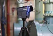
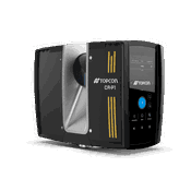
Topcon launches CR-H1 handheld reality capture solution for maximum mobility
MUNICH — Topcon Positioning Systems has announced the CR-H1, a handheld solution that represents one of the latest additions to the company’s Capture Reality portfolio of mass data solutions. The system utilizes PIX4Dcatch, a specialized application that runs on iPhone devices with integrated LiDAR that collects images and employs photogrammetry to create detailed, full-color 3D point clouds. The iPhone connects to Topcon’s HiPer CR receiver, enabling the application to collect georeferenced ima...
Topcon introduces solutions for 3D mass data workflows
MUNICH — Topcon Positioning Systems has announced new technology solutions for 3D mass data workflows. Enhancements to the Topcon Collage Site software solution provide new workflow capabilities designed to allow for the real-time acquisition and processing of data more accurately, efficiently, and quickly to provide the user with greater productivity. Collage Site software allows a single operator to scan, process, and view complete georeferenced point clouds in real time while still in the...

Dig Smarter, Not Harder: Trimble Tech Turns Excavators into Precision Construction Tool
Introducing the Trimble Siteworks Machine Guidance Module for Tilt Buckets WESTMINSTER, Colo., April 7, 2025 - Trimble® (Nasdaq: TRMB) today announced the availability of its Trimble Siteworks Machine Guidance Module for tilt bucket attachments. By integrating the full range of motion of the tilt bucket's cutting edge into the Siteworks machine guidance and layout software, field operators can now achieve precise grading and leveling, efficient ditch cleaning and shaping, accurate backfilling...
Video: Crashes Drop Measurably After Rural Road Safety Improvement Project on US 521 in Lancaster County

AdventHealth Weaverville Hospital

June Issue 2026
.jpg?width=225)