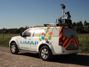
Lithuanian Survey Experts Takes Delivery of SITECO Road-Scanner
Bologna, Italy - SITECO Infomatica SRL has completed the delivery and commissioning of a Road-Scanner-4 to LiMAP, UAB of Vilnius, Lithuania. This latest delivery of the high performance Road-Scanner-4 is the first such configuration in Lithuania and the second of a SITECO mobile mapper to the Baltic region. The system is configured with two Zoller & Froelich (Z+F) 9012 Profiler laser scanners, a Point Grey Ladybug 5 spherical camera and an XBLUE Atlans IMU and inertial navigation system....
Exprodat Software Revolutionises Unconventionals Planning
Exprodat, the oil and gas ArcGIS platform specialist, Esri Gold Partner and Getech group company, has released a new version of its Unconventionals Analyst software. The company developed the Unconventionals Analyst extension to ArcGIS Desktop to help oil and gas companies simplify and speed up the processes of optimising unconventional well patterns and managing reserves. Version 222 of Unconventional Analyst includes a host of new features all of which have been designed to give the user...

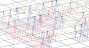
OGC Publishes Testbed 12 Aviation Thread Engineering Reports
Members of the Open Geospatial Consortium (OGC®) recently approved the release of 7 draft public OGC Engineering Reports, products of the recently completed OGC Interoperability Testbed 12 Aviation Thread. Testbed 12’s Aviation Thread was sponsored by FAA and Eurocontrol, and is the most recent in the OGC's long series of major geospatial interoperability initiatives. The 7 released draft engineering reports focus on Aviation Information Management, specifically: •Semantics - Managing comple...

Sokkia Announces New Compatibility with Autodesk Layout Application
LIVERMORE, Calif., USA/ CAPELLE A/D IJSSEL, The Netherlands — Sokkia announces its new iX robotic total station series’ compatibility with the Autodesk BIM 360 Layout application. BIM 360 Layout is designed to provide vertical construction contractors the ability to connect the coordinated model to the field layout process — helping to increase job site productivity, while improving the accuracy of staked or installed building components. “We are committed to the interoperability between o...

Esri Releases EMUs to Understand the Ocean
REDLANDS, Calif.- Esri, the world leader in smart mapping technology, announced a whole new way of measuring the ocean on September 15, 2016, at the Oceans Conference in Washington, DC. Ecological Marine Units (EMUs) are Esri’s gift to a world whose final unexplored terrain lies beneath its seas. Esri and USGS collected a series of global measurements representing the ocean’s physical and chemical properties most likely to drive ecosystem responses. From millions of measurements taken, 37 phy...

Bentley’s AssetWise InspectTech Helps State DOTs and Agencies Achieve Compliance with FHWA MAP-21 Regulations
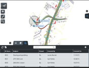
EXTON, Pa.- Bentley Systems, Incorporated, a leading global provider of comprehensive software solutions for advancing infrastructure, today announced that all 15 state DOTs and agencies using AssetWise InspectTech achieved compliance with annual Federal Highway Administration (FHWA) MAP-21 National Bridge Inventory (NBI) and National Bridge Element (NBE) reporting requirements and successfully submitted reports on time. AssetWise InspectTech delivers accurate element-level inspection data requi...
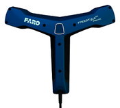
FARO Introduces Freestyle3D Objects, the First Handheld, Color Laser Scanning Solution Through FARO’s Early Adopter (EA) Program Specifically for the Public Safety Forensics and Product Design Markets
Lake Mary - FARO® (NASDAQ: FARO), the world's most trusted source for 3D measurement and imaging solutions for factory metrology, product design, construction BIM/CIM, public safety forensics and 3D solutions and services applications, introduces the FARO Freestyle3D Objects, a new medium-volume, handheld 3D Laser Scanner for crime/crash scene investigation and reverse engineering applications. With the new powerful Freestyle3D Objects, FARO expands the successful product concept of its const...
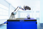
FARO Releases High-Resolution Array Imager for Factory Metrology and Product Design Applications
Lake Mary, FL - FARO® (NASDAQ:FARO), the world’s most trusted source for 3D measurement and imaging solutions for factory metrology, product design, construction BIM/CIM, public safety forensics and 3D solutions and services applications, announces the launch of a higher resolution version of the FARO® Cobalt Array Imager solution, geared toward quality inspection, factory automation and in-process verification (IPV) applications. The new 9MP version of the Cobalt Array Imager is a highe...

FARO Releases SCENE Version 6.1, Introducing a Fully Integrated Point Cloud to 3D Mesh Engine for Product Design and Construction BIM-CIM Professionals
LAKE MARY, Fla. - FARO® (NASDAQ: FARO), the world's most trusted source for 3D measurement and imaging solutions for factory metrology, product design, construction BIM/CIM, public safety forensics and 3D solutions and services applications, announces the release of SCENE 6.1, the next generation of its powerful software for efficiently processing and managing 3D laser scan data. For modeling freeform shapes such as statues, equipment, industrial components and buildings, SCENE 6.1 now offer...
Bringing the Civil Engineering Office to the Field Speeds Approvals and Helps Resolve Issues During Design, Construction, and Operations
Bentley Systems announces OpenRoads Navigator CONNECT Edition, an innovative application that provides civil and transportation professionals an easy-to-use, dynamic product for quick access to civil design information in the field. OpenRoads Navigator supports Windows, iOS, and Android. Key capabilities include: View, analyze, and augment a wide variety of project information, including geometry, 3D models, and 2D topography. Search and filter models based on attributes such...
Video: Crashes Drop Measurably After Rural Road Safety Improvement Project on US 521 in Lancaster County

AdventHealth Weaverville Hospital

June Issue 2026
.jpg?width=225)