
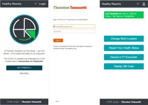
Open Source App Provides Customizable Health Reporting And Contract Tracing Capabilities New York, NY – Thornton Tomasetti has open sourced its proprietary Healthy Reentry (HR) application for health monitoring and contract tracing. Designed…

Enscape Releases Version 2.9 With Vectorworks 2021 Integration
Milestone release adds Vectorworks to Enscape’s list of fully supported 3D modeling programs Columbia, MD (November 5, 2020)—Enscape GmbH,…

Leica Geosystems innovates automated total station portfolio
Range of automated total stations now with new integrated functionalities increase productivity in any environment (HEERBRUGG, Switzerland ) –…

Polygon Announces PolySlide® Composite Tubing for Pneumatic and Hydraulic Cylinders
Ideal for replacing metallic material in a variety of cylinder applications Walkerton, IN – Polygon Composites Technology, a leading manufacturer of composite tubing solutions for bearings, dielectric applications, surgical devices…
Virtual Surveyor Introduces Curb & Gutter Mapping in New Version of Drone Surveying Software
AARSCHOT, Belgium – Virtual Surveyor has introduced Curb & Gutter mapping functionality in Version 7.6 of its popular drone surveying software. The new capability enables surveyors to create a lightweight CAD model of curbs and gutters along the edges…

IntelliCAD Technology Consortium Announces Release of IntelliCAD® 10.0a
Portland, OR, USA — The IntelliCAD Technology Consortium (ITC) today announced the release of IntelliCAD 10.0a. IntelliCAD 10.0a is a maintenance release for version 10.0 that was previously issued on July 30, 2020. IntelliCAD maintenance releases concentrate…
UP42 Partners with Intermap to Bring High-Resolution Elevation Data to UP42’s Geospatial Marketplace
NEXTMap Digital Surface Model (DSM) BERLIN, Germany – UP42 is pleased to announce that the NEXTMap Elevation Data Suite from Intermap Technologies is now offered on the UP42 developer platform for Earth observation data and analytics. The NEXTMap…
OnScale Introduces OnScale Solve™: The World’s First Cloud Engineering Simulation Platform
Silicon Valley, CA – OnScale today announced the release of the OnScale Solve, the web-based cloud engineering simulation platform bringing to engineers powerful multiphysics solvers and scalable cloud supercomputer resources. “OnScale Solve gives…
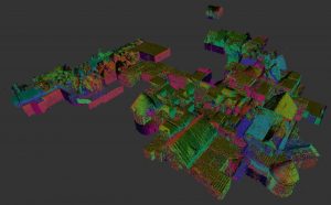
GeoSLAM Completes Spook-Tacular Scanning of Californian Landmark
The team at geospatial 3D mapping specialist GeoSLAM has produced a digital twin of one of the world’s most haunted mansions, The Winchester Mystery House, using the newly-launched ZEB Go. It may be hard to believe the feat of scanning this vast architectural…
Datumate Announces Autodesk BIM 360 Integration for Improved Construction Site Visualization and Project Management
No-code integration empowers planning and construction teams with essential construction intelligence extracted in near real-time from survey-grade reality captures. YOKNEAM, Israel – Datumate, developer of the DatuBIM Construction Data Analytics platform,…
