
Quixel, creator of the world’s largest photogrammetry 2D and 3D asset library, has joined the Epic Games family, and we’re making the entire Quixel Megascans library of more than 10,000 high-quality, production-ready assets free for all use with Unreal…

Forney LP Launches New Website to Advance ForneyVault®
Pittsburgh, PA: Forney LP, the premier supplier of construction material testing equipment, recently advanced its newest innovation, the ForneyVault®…

Eagle Point Software’s Pinnacle Series Launches Construction Tech Training Content Combined with Their Award-Winning Platform, to be Unveiled at Autodesk University Next Week
DUBUQUE, IA — Today, Eagle Point Software Corporation announced that they have added Construction content and training solutions for three popular…
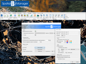
‘Spatial Manager’ 6: Now Terrains and many more
Spatial Manager version 6 (AutoCAD, BricsCAD, ZWCAD and Desktop) has just been released. You will find many improvements and new features in this version, such as the new Terrains commands. Update your application or download the free trial version here: - …

10-year Anniversary of Ideate BIMLink for Revit Brings Major Enhancements
San Francisco, CA – Ideate Software, a veteran Autodesk Developer Network member, announced enhancements to Ideate BIMLink, its Revit productivity application that simplifies model management by facilitating the movement of data from Autodesk® Revit® software…
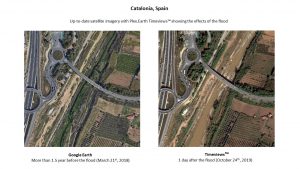
Plex.Earth Timeviews™ empowers AEC professionals with the latest satellite imagery within AutoCAD
Plexscape, developers of Plex.Earth®, one of the most popular tools for AutoCAD for the acceleration of architectural, engineering and construction (AEC) projects, launched Timeviews™, a unique service in the global AEC market, which makes the most up-to-date…
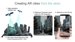
Sturfee Rolls out World’s First AR Cloud Technology for Cities that Uses Satellite Imagery to Create Magical City Experiences
Sturfee’s disruptive approach makes your smartphone cameras recognize streets using AI and Satellgery; major Japanese telco KDDI is already incorporating the production-ready tech for 5G services Milpitas, Calif. – Sturfee, a computer vision/AI solutions…
Trimble Clarity Now Offered as Web Application for Point Clouds and 3D Models
SUNNYVALE, Calif.— Trimble (NASDAQ: TRMB) announced today that Trimble® Clarity is available as a stand-alone web application that simplifies the visualization and navigation of 3D data. With this major update, Trimble Clarity enables geospatial professionals…
Trimble Announces Availability of the XR10 with HoloLens 2, a Next-Generation Mixed-Reality Solution for Front-Line Workers in Safety-Controlled Environments
DÜSSELDORF, Germany, Nov. 8, 2019—Trimble (NASDAQ: TRMB) announced today that it is now taking orders for the Trimble® XR10 with HoloLens 2 system, a worksite-ready mixed-reality solution that enables workers to visualize 3D data on project sites for easier…

Vectorworks, Inc. Brings Ultimate GIS Workflow to AEC and Landscape Professionals
Columbia, MD — GIS helps designers make better decisions. This is why Vectorworks, Inc., a global design and BIM software provider and its partner Esri, the global leader in location intelligence, are bringing Esri’s ArcGIS Online services to AEC and landscape…
