
New Trimble Terra Office Workflow Delivers Integration with Esri ArcGIS Pro
SAN DIEGO, Calif., July 11, 2023—Trimble (NASDAQ: TRMB) announced today the release of the Trimble® Terra™ Office add-in for Esri ArcGIS Pro. The add-in is a new product in Trimble’s Terra Office suite of desktop solutions for integrating Trimble TerraFlex® field data collection software with GIS systems of record. The announcement was made today at the 2023 Esri User Conference. With a streamlined user interface, the new Terra Office add-in for ArcGIS Pro allows a customer to connect Ter...

Digital Twin Consortium Publishes Platform Stack Architectural Framework
The introductory guide outlines central concepts of digital twin systems BOSTON, MA – JULY 11, 2023 – Today, the Digital Twin Consortium® (DTC®) announced the Platform Stack Architectural Framework: An Introductory Guide. The guide, designed for C-Suite and business leaders, provides foundational building blocks and central concepts of a digital twin system. System architects can use it to enable technology selection through development. “Digital twins and enabling technologies are revolut...

Perkins&Will Welcomes New Director of Practice Development in Dallas
Amber Pickett Wernick to focus on expanding the firm’s local interior design practice DALLAS— Award-winning interior designer and strategist Amber Pickett Wernick joins the Dallas studio of global architecture and design firm Perkins&Will as director of practice development. Wernick, a Dallas native who worked for Perkins&Will between 2008 and 2015, returns to the firm to play a key role in client engagement, identifying new opportunities that grow the studio’s interior design practice....

Locana Further Extends Esri and SAP Integration Leadership
Names Turchioe to Lead the Company’s Strategic Relationships with SAP, Integration with Esri, and Geo-enablement of Clients San Diego and Greenwood Village, Colo. (July 10, 2023) – Locana, an international leader in spatial technology, today announced a continued focus on the company’s key integration and strategic partnerships with Esri and SAP by naming Tom Turchioe as Global Partnership Technology Lead. Turchioe returns to the company in this newly established role to apply his marke...
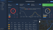
CompassCom Releases Upgraded Telematics Platform with Enhanced Situational Awareness for Asset Tracking and Fleet Management
CompassCom’s telematic tracking system CompassTrac 8.2 showing real-time dashboards. KPIs are shown for fleet or radio customer giving users important real time metrics of their telematic devices. Hybrid Solution for On Premise and Cloud Deployment CENTENNIAL, Colorado, 10 July 2023 – CompassCom Software has released Version 8.2 of the CompassCom GIS-centric hybrid telematics platform that can be deployed on premises or in the cloud for real-time asset tracking and comprehensive flee...

BlueConduit Launches a Water System-Level Lead Service Line Count and Replacement Cost Estimator
(ANN ARBOR, Mich.) — Water utilities nationwide are working to find and replace their lead service lines (LSLs) without knowing how many are in their system. To help utilities plan, water analytics pioneer BlueConduit launched a free LSL count and replacement cost estimator. The recently released tool, part of BlueConduit Starter, combines machine learning with public records to estimate the number of unknown lead service lines at the water system level. It also provides an initial cost esti...

GOVERNOR SIGNS BILL TO GROW QUALITY JOBS IN INFRASTRUCTURE PROGRAMS
Sacramento, Calif. – On Monday, July 10, 2023, Gov. Gavin Newsom signed legislation that will enhance California’s job training pipeline, community benefits, and jobs standards in state and federal infrastructure programs. The Governor was joined by the joint authors of Senate Bill (SB) 150: Senator Lena Gonzalez (D-Long Beach), Senator Dave Cortese (D-San Jose), Senator Maria Elena Durazo (D-Los Angeles), Senator Lola Smallwood-Cuevas (D-Los Angeles), and Assemblymember Luz Rivas (D-San Fernand...

Woolpert Contracted to Map Electrical Infrastructure to Help Bring Broadband Internet to Rural Texas
The contract includes the creation of survey grade 3D models of the existing electrical distribution network. DAYTON, Ohio (July 10, 2023) — Woolpert has been contracted to collect high-density lidar data for more than 6,800 square miles of rural Texas to map electrical distribution poles and wires along with surrounding natural and man-made infrastructure. The data will be collected via fixed-wing manned aircraft. The high-density point cloud will be classified and used to construct survey g...

Biden-Harris Administration Announces $130 Million for Seven Transportation Projects on Federal and Tribal Lands as Part of President Biden’s Investing in America Agenda
Applications also open for next round of funding to improve access to Federal and Tribal lands GRAND CANYON NATIONAL PARK, Ariz.– The U.S. Department of Transportation’s Federal Highway Administration (FHWA) today announced $130.5 million in federal grants for seven projects under FHWA’s Nationally Significant Federal Lands and Tribal Transportation Projects Program. The grants, announced at an event at the Grand Canyon National Park, recognize transportation projects of national signif...
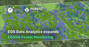
EOS Data Analytics expands EOSDA Forest Monitoring with a new customer-oriented approach and extra features
The updated version of EOSDA Forest Monitoring by EOS Data Analytics is a custom solution with an expanded range of capabilities designed for better assessment of various conditions of forest lands. EOS Data Analytics, a global provider of AI-powered satellite imagery analytics founded by Dr. Max Polyakov, releases an updated version of EOSDA Forest Monitoring, an online satellite-based software for forestry management. The new version is now offered as a custom solution that is tailored...
Video: Crashes Drop Measurably After Rural Road Safety Improvement Project on US 521 in Lancaster County

Redevelopment of Horseshoe Bay Terminal

June Issue 2026
.jpg?width=225)