Trimble Adds Inertial-Based Trolley Solution to its Track Survey and Scanning Rail Portfolio
BERLIN — Trimble (NASDAQ: TRMB) introduced today a new addition to its track survey and scanning rail portfolio—the Trimble® GEDO IMS System. The latest trolley system is lightweight, flexible and fast. It combines an Inertial Measurement Unit (IMU) with scanning and geodetic sensors for surveying railway lines and documenting assets along the track. The announcement was made today at INTERGEO 2017, the world’s largest conference on geodesy, geoinformatics and land management. Th...

Trimble Introduces New Version of eCognition Software Suite with Powerful New Geospatial Data Analysis Capabilities
BERLIN—Trimble (NASDAQ: TRMB) today announced the release of eCognition Suite 9.3, a software platform for advanced geospatial image analysis for environmental, agriculture, forestry and infrastructure applications. Version 9.3 leverages the latest image feature extraction technology to solve challenging problems faster and more accurately for remote sensing specialists, Geographic Information System (GIS) experts, cartographers, photogrammetry and other geospatial professionals. The ann...
Trimble Expands Field-to-Finish Capabilities for Geospatial Professionals with Enhancements to Software Portfolio
BERLIN—Trimble (NASDAQ: TRMB) announced enhancements to its industry leading portfolio of geospatial office software with a new version of Trimble® Business Center and the introduction of Trimble Clarity, a new cloud-based application that enables geospatial professionals to easily visualize and share three-dimensional point cloud data with clients. The new software versions expand the field-to-finish workflows for survey and mapping professionals, providing a complete solution for the delivery...
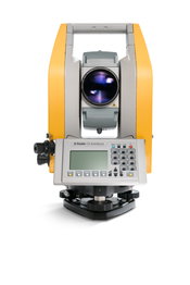
Trimble Enhances Optical Portfolio with the Next-Generation Mechanical Total Stations
BERLIN—Trimble (NASDAQ: TRMB) today announced the release of the Trimble® C5 and Trimble C3, the next generation of mechanical total stations to support land survey professionals with their cadastral survey, topographic survey and stakeout needs. The new Trimble C-Series mechanical total stations enhance the Trimble portfolio with new productivity boosting features that make everyday field work easier and faster. The announcement was made today at INTERGEO 2017, the world’s largest confe...

Amy Williams is New Managing Principal of HDR’s Minneapolis Studio
September 2017- Amy Williams, AIA, LEED AP, former managing principal, vice president of HDR’s Los Angeles architecture studio, has assumed the managing principal role in the Minneapolis studio. Originally from Iowa and a graduate of Iowa State University, Williams is a licensed architect in Washington, Nevada, Utah, Minnesota and Michigan. She has led design practices for award-winning global architecture firms for the past eight years, and she has 20 years of experience on projects in th...

FARO Announces Innovative Visual Inspect for Inspection and Design
Lake Mary, FL - FARO® (NASDAQ:FARO), the world’s most trusted source for 3D measurement and imaging solutions for factory metrology, construction BIM/CIM, product design, public safety forensics, and 3D solutions applications, announces the availability of the FARO® Visual Inspect™ product family. This innovative platform enables large, complex 3D CAD (computer-aided design) data to be transferred to an iPad and then used for mobile visualization and comparison to real world conditions (https://...
Applanix Releases Updated Version of POS LVX for High-Accuracy Positioning and Orientation for Autonomous Ground Vehicles
Berlin, Germany – Applanix, a Trimble Company, introduced today an updated version of its POS LVX system, which provides high-accuracy positioning and orientation for the operation of autonomous ground vehicles. The POS LVX can be integrated with cameras, Light Detection and Ranging (LiDAR), RAdio Detection and Ranging (RADAR), and other sensors to provide accurate Positioning and Orientation System Estimation (POSE) for localization, perception, and the production of high-precision maps critic...
Trimble Expands Portfolio of OEM Products for High-AccuracyDirect Georeferencing on Unmanned Aerial Vehicles
BERLIN —Trimble (NASDAQ: TRMB) introduced today three new GNSS-Inertial Systems for Direct Georeferencing on Unmanned Aerial Vehicles (UAVs): the Trimble® APX-15-EI UAV, Trimble APX-18 UAV, and Trimble APX-20 UAV. Direct Georeferencing with the systems allows the location of image elements collected by Light Detection and Ranging (LiDAR) and hyperspectral sensors to be accurately computed without extensive networks of ground control points, reducing costs while maintaining accuracy to produce m...

Congress Faces FAA Deadline, Eyes Taxes, Infrastructure
The House and Senate is expected to extend the Federal Aviation Administration's authorization before it expires Sept. 30, and then soon turn to such issues as tax cuts and perhaps an infrastructure investment plan. Lawmakers were reportedly largely agreed that they would approve another simple extension of the FAA by month's end without tackling controversial proposals to spin off its air traffic control functions to a new nonprofit corporation. However, various reports said they were still...

Colorado DOT Crews to Install Monitoring Technology on I-70 in Glenwood Canyon
This fall, said the Colorado Department of Transportation, crews will begin installing interconnected weather and road sensors, cameras, speed-detection devices and variable speed limit signs at 17 locations on the Interstate 70 Glenwood Canyon corridor. It is an example of how state DOTs are increasingly turning to technology projects to improve highway utilization and safety. "This section of I-70 experiences a range of weather conditions throughout the year, causing unsafe conditions f...
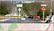
Video: Crashes Drop Measurably After Rural Road Safety Improvement Project on US 521 in Lancaster County

AdventHealth Weaverville Hospital

June Issue 2026
.jpg?width=225)