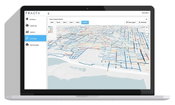
Skokie Engages New Technology To Evaluate Water Main Infrastructure
REDWOOD CITY, Calif. - Each day, the Village of Skokie residential and commercial water customers receive an average of 7.7 million gallons of drinking water that is distributed through some 180 miles of water mains throughout the community. Unexpected water main breaks are costly for the Village. In addition, they are disruptive and inconvenient for both residents and businesses, sometimes resulting in business interruption and other costly circumstances. The Village of Skokie has maintai...
Applanix Enhances POSPac Trimble Post-Processed CenterPoint RTX Correction Service to Support High-Accuracy UAV Mapping Without Base Stations
Achieve Centimeter-Level Accuracy Direct Georeferencing Using the POSPac Trimble Post-Processed CenterPoint RTX Correction Service Stuttgart, Germany, September 17, 2019 - Applanix, a Trimble Company (NASDAQ: TRMB), announced today that the POSPac Trimble Post-Processed CenterPoint® RTX™ (POSPac PP-RTX) correction service has been enhanced for use with Unmanned Aerial Vehicles (UAVs) flown within Trimble RTX Fast service regions. Available on a subscription basis within the latest release o...
Trimble 4D Control Software Provides Greater Geotechnical Sensor Support
STUTTGART, Germany, Sept. 17, 2019—Trimble (NASDAQ: TRMB) announced today an update to its core real-time monitoring software—Trimble® 4D Control. Building on the recently released version 5.0, this update delivers support for Senceive’s wireless monitoring systems, streamlining the configuration process for users and delivering real-time data from geotechnical sensors to one common platform. By receiving data through Senceive’s wireless gateways into Trimble 4D Control software, project stakeho...
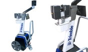
Trimble Enhances its Indoor Mobile Mapping Solution with New Software for Improved Workflow and Results
STUTTGART, Germany, Sept. 17, 2019—Trimble (NASDAQ: TRMB) introduced today two new software releases designed to further simplify and improve the workflow for indoor mobile mapping, while also improving the final map products that the Trimble® Indoor Mobile Mapping Solution (TIMMS) produces. The announcement was made today at INTERGEO 2019, the world’s largest conference on geodesy, geoinformatics and land management. TIMMS is the optimal fusion of technologies for capturing spatial da...
Teledyne Optech Introduces OEM TLS-M3 for Marine, Monitoring and Mobile Applications
VAUGHAN, Canada — September 17, 2019 — Teledyne Optech, a Teledyne Technologies [NYE:TDY] company and global leader in advanced lidar sensors, will showcase its new high-resolution, long range scanner, the TLS-M3 at InterGEO this week. The new scanner boasts powerful features including a protective encasement for marine environments, integrated inclinometer, and compass with external camera support. With the capacity to operate at up to three speeds, the TLS-M3 has ranges of 250m up to 2000m...
Applanix Releases New POSPac LiDAR Quality Control Tools for UAVs
Stuttgart, Germany, September 17, 2019 - Applanix, a Trimble Company (NASDAQ: TRMB), introduced today LiDAR Quality Control (LiDAR QC) Tools for Unmanned Aerial Vehicles (UAVs)—a new software module supported by the latest release of Applanix’ industry-leading GNSS-aided inertial post-processing software packages, POSPac Mobile Mapping Solution (MMS) and POSPac Unmanned Aerial Vehicles (UAV). LiDAR QC Tools for UAVs are specifically designed to achieve higher accuracy LiDAR point clouds from a U...

Leica Geosystems Announces Major Efficiency Improvement to Airborne Urban Mapping Solution
HEERBRUGG, Switzerland, 17 September 2019 – Leica Geosystems, part of Hexagon, introduces the Leica CityMapper-2. This next generation hybrid oblique imaging and LiDAR sensor provides fast and efficient digitisation of cities. As part of Leica Geosystems’ RealCity solution, which combines the CityMapper-2 with the Leica HxMap high-performance processing workflow, the new sensor is designed to provide faster updates while preserving image quality over a wide range of flying conditions. The...
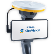
Trimble's New High-Accuracy Handheld Augmented Reality System Takes Data Visualization Outdoors
SUNNYVALE, Calif. - Trimble (NASDAQ: TRMB) introduced today its Trimble® SiteVision™ system, an outdoor augmented reality (AR) solution that enables users to visualize 2D and 3D data on virtually any project site with cellular or internet connectivity for easier and more efficient planning, collaboration and reporting. Combining hardware and software in an integrated, lightweight handheld or pole-mounted solution, users can view 3D models and assets in a real-world environment at a 1:1 scale, fr...
Teledyne Optech introduces its latest Airborne Laser Terrain Mapper for Wide Area and Corridor Surveying
New Galaxy T2000 dual-mount lidar system enables unmatched collection efficiency and point density VAUGHAN, Canada — September 17, 2019 — Teledyne Optech, a Teledyne Technologies [NYSE:TDY] company, and global leader in lidar sensing is pleased to announce the next evolution of its award-winning Galaxy™ platform, the Galaxy T2000. A compact lidar-mapping sensor, the Galaxy T2000 provides a unique feature set for maximum collection efficiency and point density, and is the next step in the evo...

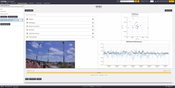
WaterStart and KETOS Partner to Address Las Vegas Water Challenges
LAS VEGAS – Through WaterStart and in partnership with the Southern Nevada Water Authority (SNWA) and Las Vegas Valley Water District (LVVWD), water intelligence innovator KETOS, Inc. has launched pilot testing of an advanced water monitoring solution, KETOS Shield Fabric, to proactively test and monitor for potential contaminants and help ensure the quality and safety of drinking water supplies. “We are thrilled to partner with KETOS to address critical water challenges facing water utiliti...
Video: Habitat for Humanity - Women Build Event in Sacramento

AdventHealth Weaverville Hospital

June Issue 2026
.jpg?width=225)