
Woolpert Maps, Models California Reservoirs to Determine Capacity, Improve Water Resources Management
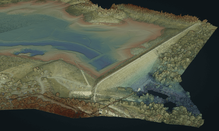
LIDAR AND MULTIBEAM SONAR DATA FROM THE DAM AT COLLINS LAKE HAS BEEN COLLECTED AND INTEGRATED TO PRODUCE A MODEL HOSTED IN A POINT CLOUD FOR EFFECTIVE RESOURCE MANAGEMENT.
The firm collected and integrated lidar and multibeam sonar data from Collins Lake and Lake Isabella.
SAN RAFAEL, Calif. — Woolpert was contracted by the U.S. Army Corps of Engineers and Pro-ROV Services for the Browns Valley Irrigation District under separate contracts to collect and integrate lidar and multibeam sonar data. These data will be used to determine the accurate capacity of two California reservoirs and to support the management of water resources.
For the Browns Valley Irrigation District project, Woolpert collected lidar data via uncrewed aircraft system and acquired multibeam sonar data with a survey vessel. These data will be used to map and model Collins Lake, a reservoir located northeast of Sacramento in the foothills of the Sierra Nevada Mountains.
Under a separate contract, the Corps selected Woolpert to collect multibeam sonar data for capacity surveys conducted at Lake Isabella, east of Bakersfield. At the same time, Woolpert was under contract to fly topographic lidar over the region for the U.S. Geological Survey 3D Elevation Program. By combining the hydrographic data collected at Lake Isabella and integrating it with USGS lidar data, Woolpert developed a high-resolution digital elevation model of the reservoir and watershed to accurately determine the capacity of Lake Isabella. This opportunity to leverage two surveys produced a valuable dataset that will be used for many years.
“With the ongoing drought, the accuracy of these data is essential to the effective management of water resources,” Woolpert Certified Hydrographer David Neff said. “Collecting and integrating lidar and multibeam sonar data ties together two technologies and creates a precise and seamless elevation model. That model is then hosted within a point cloud for state and local officials to access, so they can effectively plan and manage these critical assets.”
Neff said UAS was employed for Collins Lake and fixed-wing aircraft was used for Lake Isabella due to the specific needs of each region and each project. He added that the sonar data was collected by eTrac, a Woolpert Company, which is a vessel-based hydrographic survey firm acquired by Woolpert in February 2022 with headquarters in San Rafael.
“We are fortunate to have the staff and equipment to collect data as each project demands,” Neff said. “With three offices in California, we understand all too well the impact that the drought has on the state. Advanced technologies such as these hold the key to the state’s ability to overcome the water crisis. We are here and ready to help.”
About Woolpert
Woolpert is the premier architecture, engineering, geospatial (AEG) and strategic consulting firm, with a vision to become one of the best companies in the world. We innovate within and across markets to effectively serve public, private and government clients worldwide. Woolpert is a top 100 ENR Global Design firm, earned six straight Great Place to Work certifications, and actively nurtures a culture of growth, inclusion, diversity and respect. Founded in 1911 in Dayton, Ohio, Woolpert has been America’s fastest-growing AEG firm since 2015. Woolpert has over 2,000 employees and more than 60 offices on five continents. For more, visit woolpert.com
