
New era of property risk management enabled by transformational location intelligence technology
Nearmap automated fire risk assessments (prototype)
Nearmap announces product roadmap built on market-leading artificial intelligence platform: automated roof condition assessment, fire risk assessment, flood risk assessment, and artificial intelligence insights for natural disasters
Fifth generation of Nearmap AI also launched at annual customer event, Nearmap NAVIG8 2022
Salt Lake City, Utah — Organizations responding to the challenges of a changing climate – in sectors including insurance, government, financial services, architecture, construction, and engineering – will soon be supported by a range of transformational technologies from leading location intelligence and aerial imagery company, Nearmap. The new products will provide automated insights and enable companies to rapidly evaluate property conditions and risks.
Announcing the new product roadmap at annual customer event Nearmap NAVIG8,
Don Weigel, Senior Vice President of Product said: “Nearmap has swiftly transitioned from selling individual products underpinned by world-leading technology, to providing an irreplicable, integrated solution-stack of location intelligence data, insights and tools.”
“In this way, organizations can rely on Nearmap to provide a trusted, end-to-end solution of location intelligence technologies and aerial imagery to help them work smarter, better, and faster. Nearmap is the only company that owns the entire technology stack for location analytics, including the camera technology, image capture, processing, content, delivery, and machine learning capability. This enables us to be agile, innovative, and responsive to our customers’ needs.”
Nearmap AI: A powerful platform for a suite of analytics products
Nearmap AI is built on a rich layer of content that uses machine learning to turn Nearmap high resolution aerial imagery into information and insights, creating one of the most accurate and richest artificial intelligence offerings in the market.
The fifth and latest generation of Nearmap AI is enabled by a new deep learning model trained on a much larger data set. The product has grown to an automated map of 78 layers (from 49 layers in the fourth version), and more than 500 facts per address. It includes performance enhancements to existing layers. There are also five new AI packs, which bundle these artificial intelligence layers into products for different use cases (roof objects, debris, surface permeability, and pavement markings [alpha]).
A full list of the Nearmap AI packs and layers is available here.
Dr Tom Celinski, Chief Technology Officer at Nearmap, said: “The fifth and latest generation of Nearmap AI offers more than high-definition vector maps, and additional automated location insights. It also serves as a powerful platform for a suite of new AI-derived products and technologies that will transform how organizations gain data and insights to make better decisions.”
Transforming insurance claims and underwriting
The launch of the latest generation of Nearmap AI will enable a range of advanced analytics products that will transform property risk management. The product roadmap announced at Nearmap NAVIG8 2022 includes:
- Automated, AI-derived insights applied to aerial captures of weather catastrophes and natural disasters: Nearmap already commits tocapture aerial imagery following major natural disasters in Australia and the U.S. that have a significant impact on property, infrastructure, and communities – as part of the Nearmap ImpactResponseâ program. The firm has announced it will now apply Nearmap AI on this data to provide rapid, automated insights enabling first responders, insurers, government departments, and other organizations to assess damage, direct critical aid, and expedite the processing of insurance claims to people and areas in greatest need.
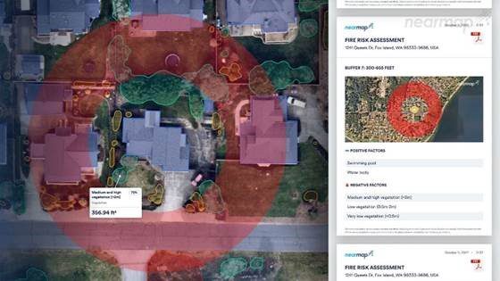
- Automated, AI-derived assessments for roof condition, fire, and flood: Nearmap 3D and Nearmap AI power three new products on the roadmap which assess property risk. These products are developed with input from Nearmap customers and respond to pressing environmental challenges. The first product available to customers will be automated roof condition assessments – offering a ‘health check’ for roofs. Fire risk assessments, and flood risk assessments will also be available to customers over the next year.
Dr Michael Bewley, Senior Director, AI Systems said: “As the world and weather changes, Nearmap is supporting organizations by applying our world-leading machine-learning capability to our extensive library of historical and current location data to create nuanced environmental risk models. Our data includes proprietary large-scale, high-resolution maps of urban environments and terrain features which have a strong impact on the way floods and fires move through the landscape. This will help organizations to better predict, prepare, and respond to the evolving challenges of a changing climate.”
World’s leading aerial camera system, HyperCamera3, now in flight
Nearmap is offering unmatched productivity and efficiency from its new patented and proprietary aerial camera system, HyperCamera3, which will capture spring leaf-off content in North America in early 2023.
Features and benefits of HyperCamera3 include:
- Higher quality imagery, including better resolution
- Better 3D reconstruction and asset inspection through 360-degree capture angles
- Better insights, via four-band imaging with new near-infrared capability that powers better artificial intelligence data
- Expanded coverage, through faster captures and wider reach
Big enhancements to Nearmap MapBrowser
Nearmap has also announced three big enhancements to its flagship mapping tool, MapBrowser, that complement its market leading city-scale 3D content, artificial intelligence data sets, and geospatial tools:
- Improved AI visualization: With improved AI visualizations, MapBrowser users will access the insights of Nearmap AI without the need for IT integration. This allows more users to view and export Nearmap AI features as raster and vector layers
- MapBrower collaboration: Over a series of upcoming releases, Nearmap MapBrowser users will gain access to a new set of tools to enable multi-user project collaboration. This enables teams to share insights and work, improving efficiency and productivity
- GeoData Link integration: Customers now have another powerful way to integrate their data directly with Nearmap MapBrowser. GeoData Link allows customers to bring Esri data directly into their Nearmap MapBrowser session
The transformational product roadmap was announced at the annual customer event, Nearmap NAVIG8 2022, where thought leaders and industry experts shared real-world examples of how aerial imagery, location intelligence, and Nearmap technology and content is helping organizations to better understand and shape world trends.
- For standard, vertical imagery (7.5cm or better), and Nearmap AI
- Includes multiple and recurring captures of the same areas
About Nearmap | nearmap.com
Nearmap (ASX:NEA) provides easy, instant access to high resolution aerial imagery, city-scale 3D content, AI data sets, and geospatial tools. Using its own patented camera systems and processing software, Nearmap captures wide-scale urban areas in the United States, Canada, Australia, and New Zealand several times each year, making current content instantly available in the cloud via web app or API integration. Every day, Nearmap helps thousands of users conduct virtual site visits for deep, data-driven insights—enabling informed decisions, streamlined operations and better financial performance. Founded in Australia in 2007, Nearmap is one of the largest aerial survey companies in the world.
