
Hexagon announces aerial data collection of eight U.S. states at 6-inch resolution
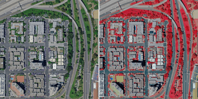
6-inch resolution RGB (left) and CIR (right) aerial imagery of San Diego, California (Source: HxGN Content Program)
(Norcross, Georgia, USA, 7 September 2022) Hexagon’s Geosystems division announced today that the HxGN Content Program will refresh data for eight U.S. states during this year’s collection season. All states — California, New York, Pennsylvania, Oregon, Kentucky, Michigan, North Carolina and West Virginia — will be updated at 6-inch (15-centimetre) resolution statewide, marking the program’s shift from a 12-inch to 6-inch wide-area acquisition for the contiguous United States.
The 2022 collection will add 558,349 square miles (1,446,116 square kilometres) of 4-band orthoimagery, stereo imagery and imagery-derived digital surface models to the Content Program’s existing collection of over 10.5 million square miles across North America and Europe. The refreshed aerial data will be available starting in Q4 of 2022 as weather conditions allow. The aerial imagery can be streamed using standard mapping APIs or downloaded through the HxGN Content Program’s Data Store. Data availability can be tracked through the HxGN Content Program’s coverage map.
Starting this year, data will be collected using the Leica ContentMapper, a high-performance imaging sensor with twice the efficiency of previous sensor generations at the same acquisition parameters. The sensor is optimized for large-area mapping and equipped with Hexagon’s unique mechanical forward-motion-compensation (FMC) technology to provide the highest imagery quality and fidelity. The ContentMapper allows the HxGN Content Program to offer more flexibility to state governments in fine-tuning their statewide aerial imagery needs.
“We enable state governments to make better-informed, strategic decisions by offering the highest quality and consistent aerial data,” says John Welter, President Geospatial Content Solutions at Hexagon. “From leaf-on or leaf-off imagery to multiple acquisitions within one flying season, the investments we are making in advanced technology such as the Leica ContentMapper enables states’ to build a reliable imagery program that promotes sustainable, thriving communities.”
If you are interested in learning more about new aerial data in your state, please inquire at [email protected].
To learn more about the HxGN Content Program, visit hxgncontent.com.
About Hexagon
Hexagon is a global leader in digital reality solutions, combining sensor, software and autonomous technologies. We are putting data to work to boost efficiency, productivity, quality and safety across industrial, manufacturing, infrastructure, public sector, and mobility applications.
Our technologies are shaping production and people-related ecosystems to become increasingly connected and autonomous – ensuring a scalable, sustainable future.
Hexagon’s Geosystems division provides a comprehensive portfolio of digital solutions that capture, measure, and visualise the physical world and enable data-driven transformation across industry ecosystems.
Hexagon (Nasdaq Stockholm: HEXA B) has approximately 23,000 employees in 50 countries and net sales of approximately 4.3bn EUR. Learn more at hexagon.com and follow us @HexagonAB.
