Trimble Introduces Next Generation High-Accuracy Mapping Solution for GIS Field Applications
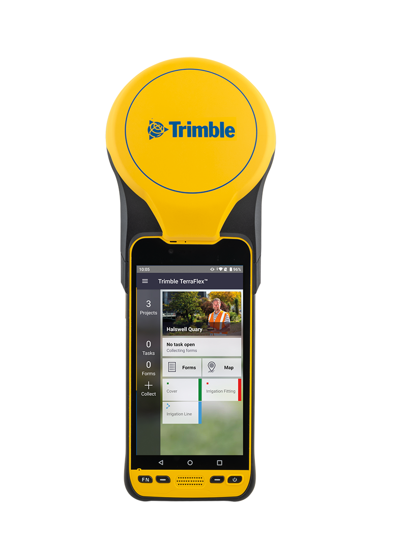
SUNNYVALE, Calif.— Trimble (NASDAQ: TRMB) announced today a new high-performance data collector for its Mapping and Geographic Information Systems (GIS) portfolio—the Trimble® TDC650 handheld. Built for GIS data collection, inspection and asset management activities, the TDC650 provides users a rugged solution with scalable high-accuracy Global Navigation Satellite System (GNSS) positioning for professional field workflows.
The TDC650 is fully integrated with today’s demanding GIS data environment, powered by the Trimble Software Development Kit (SDK) that enables precision GNSS positioning for industry leading apps such as Esri® ArcGIS® Field Maps and Trimble TerraFlex™ software. The TDC650 is also a scalable solution that allows customers to choose their desired accuracy down to the centimeter-level to meet needs and budget requirements.
“This is an ideal tool for customers tasked with modernizing critical utilities including electric, gas and telecommunications networks,” said Gareth Gibson, marketing director, Trimble Mapping & GIS. “The precision, quality and data integration workflows needed to map the physical world to a digital one in these projects requires a modern data collection platform like the TDC650.”
City, state and local governments and utilities organizations will benefit from this solution, which is part of the larger Trimble Public Sector ecosystem that includes Cityworks software for stormwater inspections and Trimble Unity for monitoring municipal water pressure and hazards. As GIS data continues to grow more complex, Trimble becomes central to simplifying, visualizing and making sense of the data so customers can make better decisions in managing their communities’ assets.
Availability
The Trimble TDC650 handheld is expected to be available in July through Trimble Geospatial Distribution Partners. For more information, visit: https://geospatial.trimble.com/products-and-solutions/trimble-tdc650.
About Trimble Geospatial
Trimble Geospatial provides solutions that facilitate high-quality, productive workflows and information exchange, driving value for a global and diverse customer base of surveyors, engineering and GIS service companies, governments, utilities and transportation authorities. Trimble's innovative technologies include integrated sensors, field applications, real-time communications and office software for processing, modeling and data analytics. Using Trimble solutions, organizations can capture the most accurate spatial data and transform it into intelligence to deliver increased productivity and improved decision-making. Whether enabling more efficient use of natural resources or enhancing the performance and lifecycle of civil infrastructure, timely and reliable geospatial information is at the core of Trimble's solutions to transform the way work is done. For more information, visit: geospatial.trimble.com.
About Trimble
Trimble is an industrial technology company transforming the way the world works by delivering solutions that enable our customers to thrive. Core technologies in positioning, modeling, connectivity and data analytics connect the digital and physical worlds to improve productivity, quality, safety, transparency and sustainability. From purpose-built products to enterprise lifecycle solutions, Trimble is transforming industries such as agriculture, construction, geospatial and transportation. For more information about Trimble (NASDAQ: TRMB), visit: www.trimble.com
Author

Parul Dubey
Video: New Roundabout Under Construction at McIver and Old Florence Roads in Darlington County

K2b Cantonal Highway

June Issue 2026
.jpg?width=225)