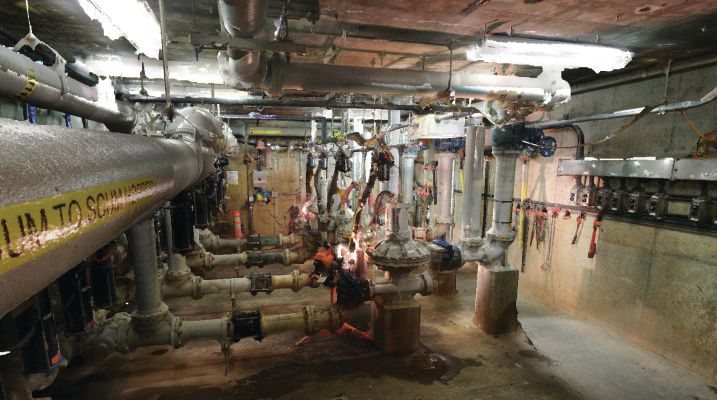
Maintaining water and wastewater infrastructure often is challenging. Water facilities rely on large, often-complicated networks of piping, steel structures, equipment and tanks that aren’t always easily accessible. These elements often are located in areas difficult to reach, and therefore it can be difficult to confirm measurements and verify accuracies of existing drawings. They also can be located underground and behind facility walls, and it can be difficult to create maintenance schedules and plan for routine part replacements when you don’t know what you’re dealing with.
For newer water facilities, these disadvantages can be offset somewhat by the original blueprints, CAD models or other drawings. But even when these documents are available, you’re still at the mercy of the designer’s original work and the questionable accuracy of the drawings. Infrastructure elements also change through time as improvements are made, and designers’ models and drawings often aren’t updated to reflect those changes.
For older facilities, where original drawings may be missing, operators and maintenance professionals often are completely in the dark when it comes to understanding their infrastructure, making proper management and maintenance of assets very difficult.
But imagine if you could create a detailed and accurate view of your infrastructure using reality-capture technology. You wouldn’t have to rely on old drawings that may be obsolete or inaccurate, even if you can find them.
To that end, water and wastewater plant administrators are turning to reality-capture technologies—such as 3D scanning—to provide complex, accurate views of their facilities infrastructure, its exact location within the complex, and whether it’s functioning as it should.
Using 3D scanning, reality capture and modeling, engineers can capture precise measurements of all types of infrastructure, including piping, steel, equipment and tanks. High-precision lidar cameras can capture data about every element of a water plant’s buildings and infrastructure, even if that infrastructure is hidden underground or behind walls.
The cameras, which utilize Class 1 lasers (i.e., safe for eyes and can be used without shutting down the facility), are accurate to +/-1 millimeter and can be inserted underground and in hard-to-reach areas. Scanning also can take place throughout different stages of construction to layer assets that will be hidden behind walls or underground as well as have the virtual ability to fly through walls and see what’s there. Depending on the predefined quality and detail required, each scan takes about three to seven minutes, and entire complexes and worksites can be mapped in a matter of hours. Even huge complexes can be mapped in just a few days.
The cameras weigh about 10 pounds, and an engineer can operate two cameras simultaneously, typically on tripods. The cameras also can be attached to drones or robots to capture difficult-to-reach or dangerous spaces. The data are collected on an SD card located in the camera or transmitted directly to laptops through internal WiFi connections while scanning onsite.
New Processes
Typically, when a site just has models, the data are used with a computer running CAD software. During the last 25 years, CAD has become a standard tool for engineers and architects because it allows them to manipulate elements of a design on a computer screen before the first shovelful of dirt is moved.
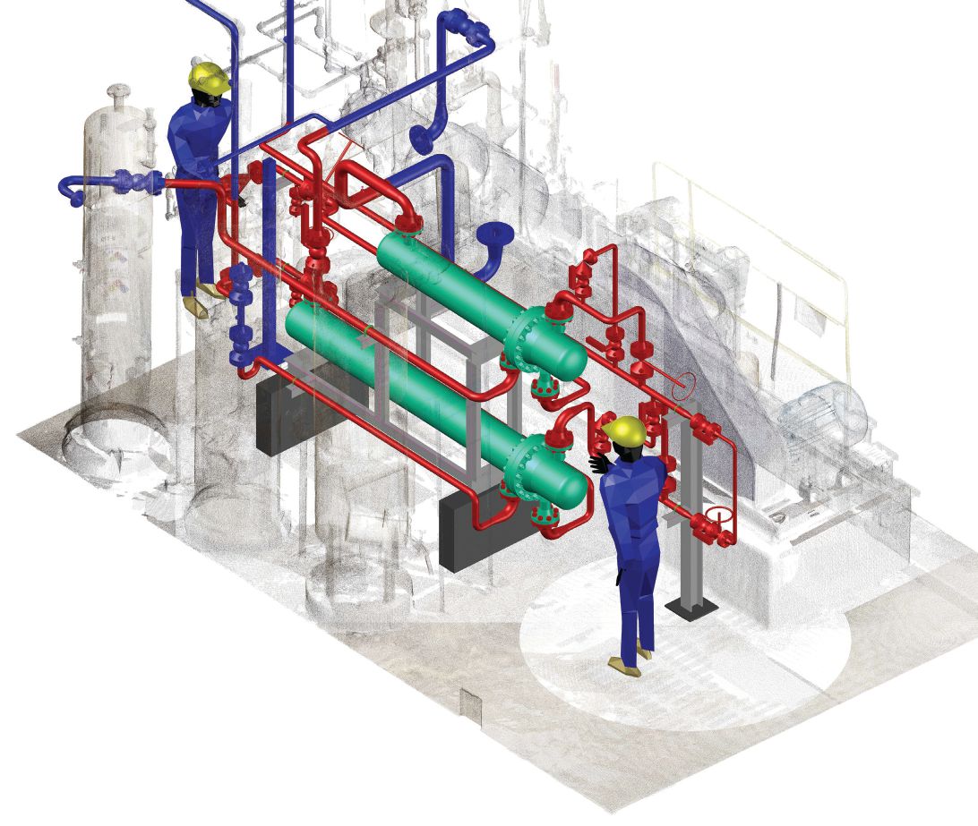
With 3D scanning, the process is a little different. CAD typically is used by engineers to create new buildings in a virtual setting—and 3D scanning certainly can help in that regard—but it also can be used in conjunction with CAD to recreate an existing water-management building or complex. The data collected in the scanning process (i.e., point clouds) are uploaded, so engineers using CAD software can combine the models and point clouds together to work with a detailed and accurate electronic rendering of an existing building or site. The electronic rendering serves as a 3D blueprint of the entire facility that can be used by engineers and maintenance professionals to develop plans for keeping equipment running properly as well as replacing parts suffering from excessive wear and tear.
Renderings also can be used by engineers to gain a better understanding of the site and existing operations when planning and completing expansions or upgrades. The scans offer a comprehensive view of the site so new elements and upgrades can be perfectly integrated with existing systems.
Mapping Existing Facilities and Sites
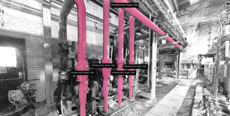
3D reality capture is the perfect tool for mapping and capturing existing water plants and sites. The cameras can reach virtually any place in the facility and provide an accurate representation of all structural and infrastructure elements as well as the site itself.
For instance, the technology can be used to conduct tank analysis and inspections. After capturing every square inch of a tank using 3D scanning, 3D tank models can be created that allow for deformation analysis and visual inspections, including inspection of otherwise unreachable infrastructure, to be completed virtually. Because the facilities can be inspected virtually, the risk to inspectors is significantly reduced, as they can access all areas of a facility from the safety of their desk. The high level of details captured also can be used in modeling software to identify deformation, cracking or other points of concern.
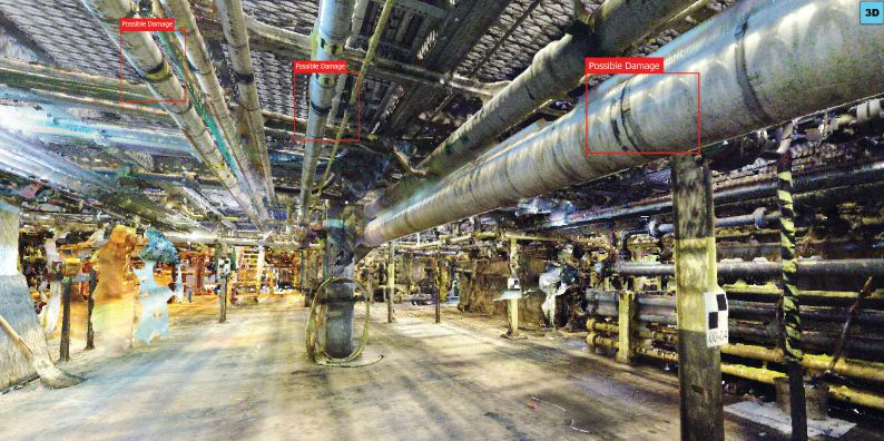
One of the most exciting recent developments in 3D reality capture has been the introduction of artificial intelligence (AI) and machine learning (ML). By incorporating AI and ML into 3D facility/infrastructure models, the technology can recognize recurring problems and look for those problems during future scans. The technology has been especially useful for performing inspections.
For example, a facility’s pipes and pumps can be scanned to create a virtual model that’s then enhanced by incorporating AI and ML technologies. The AI can essentially inspect the infrastructure and tag maintenance issues within the 3D reality-capture scans.
As water infrastructure evolves and advances, the software itself will continue to learn so it can remain a valuable and accurate assessment tool for infrastructure within 3D reality capture. Through time, the AI/ML technology can eliminate the need for staff to review every 3D scan manually, because the technology trains itself to recognize any potential problems. In addition to saving money and many staff hours that would ultimately be spent reviewing virtual 3D facility models, AI features eliminate human error and oversight.
Useful for New Construction
Although the technology typically is used to map older facilities and buildings where detailed drawings and blueprints may no longer exist, 3D scanning also can be useful during the development of new water and wastewater complexes.
In the case of water and wastewater development, 3D scanning technology can be useful in the early stages of the planning and design process. For instance, it can be used to scan an entire site on which a project is being developed, starting with using 3D cameras to capture the site. Using data-driven simulation and modeling, engineers can see how various elements of the facility would best fit into different parts of the site.
Sometimes, design teams find their planned building and infrastructure placement isn’t optimal, and the building or complex would actually work better in a different location or in a different configuration. The virtual 3D models allow developers to see where infrastructure such as buildings, equipment, electric, piping, pumps and tanks would best fit into the design.
The technology also can be useful for construction management; it’s not just buildings that can be moved around and manipulated. Project managers can experiment with different placements of various pieces of construction equipment to see how they should be deployed. In essence, the technology allows project managers and their design teams to complete a virtual runthrough of the design, planning and construction processes to make sure there are no surprises when it’s time to construct the facility and bury infrastructure elements. There’s no room for error when constructing a water or wastewater facility, and having the flexibility to do a dry-run virtually can save a lot of time, money and frustration.
The technology can even come in handy during the construction process itself. Progressive scanning can be conducted during the framing of buildings and after the drywall is up. In addition, piping being placed underground can be scanned before it’s covered, providing a record of where it’s located within the virtual model. The scans then can be overlaid on top of each other to provide a 3D representation of the entire complex.
When it comes to installing tanks, pipes and other infrastructure, time-lapse scans can be useful. By scanning at the very beginning of the project and then continuing with time-lapse scans, engineers and construction managers can keep better track of where they are in the construction process and look for discrepancies.
If some element of the job isn’t meeting expected requirements, you don’t have to wait for the system to fail before recognizing and addressing the issue. For example, time-lapse scans may show that support elements intended to hold tanks in place aren’t sufficient after the infrastructure is in the ground. In that case, engineers would be able to add additional bracing to support the tank before the facility begins operations, rather than waiting for the tank or related system to fail during operations. This is another example of how 3D scanning can save valuable time and money as well as help avoid frustrating operational failures.
A Valuable Tool
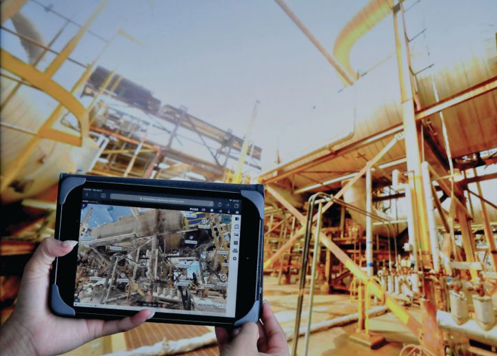
Imagine how much more effectively you could manage your water facility if you could virtually fly through the entire facility, seeing a digital-twin version that allows you to measure and maintain assets from anywhere in the world. 3D scanning provides unprecedented access to your infrastructure and allows you to take very precise scans to make sure it’s structurally sound and continues to operate as it should. This is extraordinarily helpful when it comes to creating operational and maintenance plans as well as sharing information with vendors and contractors.
When building a new facility, imagine how beneficial it would be to build a virtual model and move it around the lot on which it will be built to make sure there are no unanticipated issues presented by the site or building plans. Reality-capture technology can do this, too. It’s not quite like having a crystal ball to see into the future, but when it comes to your site design, it’s pretty close.

Mark Franklin
Mark Franklin is 3D Reality Capture Lead Account Manager at Kleinfelder; email: [email protected].
Video: New Roundabout Under Construction at McIver and Old Florence Roads in Darlington County

Bridge Replacement at Amsterdam Centraal Station

June Issue 2026
.jpg?width=225)