
The city of Dubai takes its smartness and its happiness very seriously. In fact, happiness is the stated end goal of all the ambitious and clever initiatives the city launched since the start of its Smart Dubai program in 2013. The all-encompassing strategy influenced the creation of the United Arab Emirates’ (UAE) first-ever Minister for Happiness and Wellbeing, and it’s ultimate aim is to transform Dubai into the smartest and happiest city on Earth.
A significant part of Smart Dubai has been GeoDubai, a comprehensive scheme managed by Dubai Municipality’s GIS Center to collect and provide all geospatial data and related services to government, educational and private entities within the entire UAE.
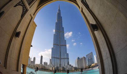
Dubai is synonymous with looming skyscrapers and construction, including the Burj Khalifa (top inset), the world’s tallest building at a height of 828 meters and 160 stories.
“The Dubai government believes that geospatial data is one of the core elements of creating the happiest and smartest city in the region,” says Maryam Obaid Almheiri, the GIS Center’s director. “Geospatial data is essential for effective urban planning, infrastructure, security and health, all of which contribute to smart services that make Dubai a livable, sustainable, innovative and growing hub of happiness. The key for us has been the ability to accurately map the city as fast as it develops.”
To give them both the mapping speed and precision it needs, the GIS Center acquired a vehicle-mounted mobile mapping system that captures centimeter-grade spatial data at highway speeds without sacrificing data quality or crew safety. The new system has not only enabled the group to image all the major roads, landmarks and buildings in the emirate in record time, it’s driving them toward successfully supporting Dubai Municipality’s ultimate smart goal of building Dubai’s “Digital Twin,” an entire 3D model of the city’s exterior and interior infrastructure.
Keeping Pace
The GIS Center has been collecting and processing geospatial data of the whole emirate of Dubai since 2001, when His Highness Sheikh Maktoum bin Rashid Al Maktoum, vice president and prime minister of the UAE and ruler of Dubai, issued a law proclaiming Dubai Municipality’s GIS Center as the sole official body responsible for the task.
As such, it has routinely acquired aerial photography and satellite imagery of the emirate and created 3D models and topographic maps using photogrammetric techniques. It also has, on a nearly daily basis, used traditional total stations and GNSS RTK technology to survey roadways, parks and street furniture as well as collect as-built surveys. For street-view imagery, it has previously turned to commercial vendors. All the data sources are offered through a centralized portal to support a host of public services such as civic planning, building design and legislation, transportation, addressing, and utilities.
Keeping pace with its ever-changing city, however, hasn’t been easy, especially in the area of urban development.
“In Dubai, it seems there is a new feature or development added every day,” says Almheiri. “We can’t get aerial photography and satellite imagery fast enough, commercial vendors don’t provide blanket coverage, and capturing construction with traditional survey technology is time consuming. Setting up total stations and GNSS receivers along active roadways is also a constant risk for our crews. With the launch of GeoDubai, we knew we’d need an inhouse mapping system that would allow us to control our data-acquisition program, coverage and accuracy requirements, and would give us the means to safely and precisely capture Dubai’s infrastructure as it’s changing.”
In late 2018, the GIS Center acquired the Trimble MX9 mobile mapping solution, a field-to-finish system that combines high-density laser scanning, one spherical and three planar cameras for panoramic and multi-angle imagery, and a high-precision Applanix GNSS (IMU) component.

A GISC field engineer (Top)mounts the MX9 imaging system on top of an SUV.Thanks to the MX9’s overhead reach of up to 400 meters, crews can capture nearly all of Dubai’s tallest buildings.

“The MX9 has four cameras that capture panoramic and multi-angle images, and two laser scanners that each capture 1 million points per second as you drive,” says Mohamed El Mustafa, the GIS Center’s MX9 project manager. “That gives us an incredibly high-density point cloud as well as incredibly rich images of every feature on the road. Nothing’s missed. And we can acquire those significant data volumes in a fraction of the time of a traditional survey. It’s the key to us successfully achieving the goals of GeoDubai.”
As the first government department in the emirate to own a mobile-mapping system, the GIS Center began using the MX9 in a number of parks and exhibition areas to familiarize themselves with the technology and calibrate it to provide the functionality and data quality they require. By mid-2019, the Center had initiated its first major mobile-mapping project: imaging and scanning the emirate’s roads and urban infrastructure.
Seriously Smart
The GIS Center’s geospatial information is at the heart of most of Dubai’s smart city initiatives. Some of the highlights from this long list include the following:
• The Happiness Meter: One of Dubai’s first smart city initiatives, the Happiness Meter allows private-sector and government entities to collect users’ happiness levels through a touch-point app. Users rank their experience through a simple interface, and the data is consolidated and mapped citywide through a centralized dashboard. The happiness map is considered among the first of its kind in the world.
• Smart People: This program promotes digital literacy and empowers residents to take advantage of the services and cultural events of the city. For example, people can access health and educational services online. They can easily book appointments and view medical results, or enroll in courses and pay tuition.
• Smart Living: This plan aims to improve services and prepare the city for environmental and other challenges. For example, it incorporates technologies into the water and electricity infrastructures to help identify and manage outages, and it supplies communication technologies to help coordinate the response of authorities and residents to emergencies.
• Smart Dubai Data: Through this initiative, Dubai plans to build a citywide model of its data, identifying which organizations hold it, and how it can be used to build a smarter, more-prosperous city. They’re preparing stakeholders to share citywide data seamlessly to fuel the city’s smart transformation and create a new approach to data management.
Dubai in 3D
To begin, teams first focused on Dubai’s roughly 12,000 kilometers of roads, targeting major routes and landmarks such as the Global Village festival and amusement park, the Old Souk markets and Dubai’s downtown. The aim was to capture every existing feature on and along the road to create 360-degree street views, point clouds, and 2D and 3D base maps of the 60- by 60-kilometer emirate.
To provide geospatial referencing to the MX9 system, the Dubai Municipality Survey Department has a network of roughly 12,000 existing ground control points (GCPs) to provide centimeter-accuracy control for the mobile mapping. The department also has a network of Virtual Reference Stations (VRSs) to support RINEX post-processing for the MX9’s GNSS.
With the MX9 mounted on top of their SUV, a two-person crew drove the roadway in two directions. Traveling at 80 kilometers/hour, the system scanned road furniture such as road signs, light poles, stop lights, markings and medians––any feature within 400 meters of the road––and captured nine images (panoramic and multi-angle) every five seconds. Simultaneous to the image capture, the system collected a point cloud of the AOI at 2 million points per second. On average, it took the team two to three hours to acquire 100 kilometers of data per day on both sides of the roads.
“A notable benefit of the MX9 is not only that it has two scanners, but also their positioning angle, which allows us to capture features that could potentially be blocked if we only had one scanner,” says El Mustafa. “Dubai, for example, has heavy traffic, so it would be easy to miss a feature because a car passes you. Two scanners ensure that if one is momentarily blocked, the other will scan those points. In addition, the MX9’s overhead reach is up to 400 meters high, so we can capture nearly all of Dubai’s tallest buildings to create an accurate and true 3D model of the city.”
The GIS Center completed its first project phase of capturing all of Dubai’s major roadways, landmarks and buildings in 3D in April 2020. For the remainder of 2020, teams were focusing on collecting the rest of the road network, landscapes and infrastructure to complete the 3D mapping of the entire emirate.
“We wouldn’t have been able to finish this major achievement this quickly without the MX9,” says El Mustafa. “A surveyor using conventional technology would likely need nearly two months to cover the same amount of distance we collect in one day. And they’ll maybe acquire about 200 points a day. We get 360-degree panoramas every five seconds and 2 million 3D points per second of everything that’s there. There’s no comparison.”
No Need To Explain
After each data acquisition, a team used a suite of Trimble software tools to process the data. When the MX9’s GNSS and inertial data were processed with POSPac, Trimble Business Center software integrated the trajectory information and control-point measurements to georeference the data collected from the MX9 cameras and scanners. They also processed and colorized each point cloud. And from the 3D view, they extracted a host of features such as road furniture, signs, houses and building outlines to produce vectorized maps for GIS-based analyses.

The street view, panoramic images, point clouds and base maps then were published to the GIS Center’s GeoDubai advanced geospatial portal, giving public and private end users the ability to view, measure and study any feature or structure in the city. And at the end of June 2020, the 3D mobile mapping data was integrated with the GIS Center’s latest smart innovation: Dubai Here, a Web browser system that offers access to geospatial data, including maps of Dubai’s landmarks, commercial and residential structures, parks, trees, bridges, tunnels, and transit network.
“What makes the mobile mapping data so effective is that no explanation is needed,” says El Mustafa. “Unlike with a singular GNSS survey point, with the MX9 street views, users can see the whole city in front of them, not just a point or polygon. A photo gives 1,000 explanations. And that makes it so much easier to use.”
In addition to providing precise panorama and measurable 3D views of the city, the GIS Center is also capturing and mapping the interiors of commercial and public buildings to bring that same 3D view and analysis inside. Using the Trimble Indoor Mobile Mapping Solution (TIMMS), the cart-mounted lidar and camera systems scan and image every room and object in an interior space—including desks, chairs, stairs, doors, plants, sprinklers and vents—and provide real-world positions of each area of the building and its contents.

Integrating the MX9 data with the internal TIMMS data will not only offer end users a holistic view of Dubai’s buildings and landmarks, it will provide the foundation to ultimately create the city’s Digital Twin, a complete 3D model of the whole city. That model, enhanced with Internet of Things technologies and linked to real-time information, will provide the essential information for planning and managing the city and providing effective, smart services.

“Data-rich images and 3D maps give decision makers precise, up-to-date and dynamic information to support and effectively manage our core city functions,” says Almheiri. “For example, in emergency response, civil defense can immediately know the height, accessibility and complexity of a burning building’s shape, giving them the knowledge to plan the most effective response. Planners can use 3D maps to monitor and assess building ages and develop effective demolition strategies. Engineers can develop road design or maintenance in 3D. This is the kind of data depth and innovation we need for Dubai’s future Digital Twin and, most importantly, to build the smartest and
happiest city.”
And in the end, that’s what it’s all about for Dubai: being smart and happy. It may have a penchant for creating a city of “ests”––tallest, largest, fastest, easiest, cleanest––but the most important “est” for the Dubai government is being the smartest and happiest city. And that’s no laughing matter.

Mary Jo Wagner
Mary Jo Wagner is a freelance writer & has been covering the geospatial industry for 25 years; email: [email protected].
Video: New Roundabout Under Construction at McIver and Old Florence Roads in Darlington County

Promenade at The Point

June Issue 2026
.jpg?width=225)