
Leica Geosystems Announces BLK3D Update
Leica BLK3D – the in-picture measurement solution
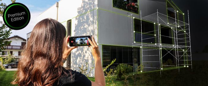
(HEERBRUGG, SWITZERLAND, 18 March 2021) – Leica Geosystems, part of Hexagon, today announced the Leica BLK3D update. The new handheld imager has doubled its operating range and in-picture measurement accuracy for many indoor and outdoor applications, such as exterior building measurements for scaffolding, façade, roofing, and architecture projects.
The BLK3D users can capture façades of four-storey buildings with centimetre accuracy in seconds. In addition, users benefit from new guidance and accuracy indication features that allow them to optimise the capturing process to achieve highest measurement accuracy. This is achieved by significantly enhancing BLK3D image processing algorithms alongside workflow adaptation which allows for capturing multi-shots with up to 4 shots.
The BLK3D Update is rolled out with the new BLK3D Mobile and Desktop software version 3.0.
The simplest step into digitalisation
BLK3D with Publisher license enables seamless collaboration among teams with increased accessibility to published 3D images through the cloud. Therefore, measurements can be created and shared on mobile devices such as smartphones and tablets for project teams to make the right decisions at the right time.
“Detailed project documentation, team collaboration and remote decision making are just a few of the needed abilities for today’s professionals across a wide variety of industries,” said Tobias Heller, senior product manager for Leica BLK3D. “In developing the latest version of the software, these needs were our focus. We designed BLK3D mobile and desktop 3.0 for users starting their journey into digitalisation and digital experts who have already been working in the area for some time. With the increased accuracy, longer range and added functionality, the BLK3D is for anyone who is looking to make their work more efficient, effective and productive.”
Leica Geosystems – when it has to be right
Revolutionising the world of measurement and survey for 200 years, Leica Geosystems, part of Hexagon, creates complete solutions for professionals across the planet. Known for premium products and innovative solution development, professionals in a diverse mix of industries, such as aerospace and defence, safety and security, construction, and manufacturing, trust Leica Geosystems for all their geospatial needs. With precise and accurate instruments, sophisticated software, and trusted services, Leica Geosystems delivers value every day to those shaping the future of our world.
Hexagon
Hexagon is a global leader in sensor, software and autonomous solutions. We are putting data to work to boost efficiency, productivity, and quality across industrial, manufacturing, infrastructure, safety, and mobility applications. Our technologies are shaping urban and production ecosystems to become increasingly connected and autonomous — ensuring a scalable, sustainable future.
Hexagon (Nasdaq Stockholm: HEXA B) has approximately 21,000 employees in 50 countries and net sales of approximately 3.8bn EUR. Learn more at hexagon.com and follow us @HexagonAB.
