It’s possible to make data accessible by anyone and get the job done anywhere, anytime.
If 2020 taught us anything, it taught us that we must be remote. Many involved in mapping and planning cities are realizing that not only do things change, they change fast. With that change comes a massive amount of new and updated data, and staying current requires the skillful deployment of digital data management. For cities—where more than half of the world’s population lives—that data and cadastral information can come from a dizzying amount of data sources, such as utilities, healthcare, telecommunications, taxes, voting and construction.
Managing this data from a central repository was difficult enough prior to physical distancing. As the world was collectively forced into remote work, to successfully accomplish this necessary goal, many organizations made networking and data available in shared environments.
For many government agencies, working from home hasn’t advanced quite as rapidly due to security, data size, old technology, and outdated workflows and policy. But even before the COVID-19 pandemic, some innovators were showing the value of removing the silos and making data more accessible from anywhere and anytime. Now, many governments are showing much greater use of shared environments to remove silos, manage data and work remotely. And many governments are showing much greater use of technology to work remotely; what may have been a strong stance against shared access to information—an accessible single view of truth—is now the new normal.
3D Mapping Supports Digital Twins
One important and useful organizing paradigm for digital data management in cities is digital twins. A digital twin is the digital representation of a physical asset, process or system that allows us to understand and model its performance. Digital twins are continuously updated with data from multiple sources, which is what makes them different from static, 3D models. Put another way, digital twins are far more than a 3D GIS. Digital twins imply a 4D component: the massive and continuous updating of a central 3D model of a city and all its systems.
At Bentley Systems, agglomerating, organizing and making use of that data has always been a priority, and it’s a difficult task for a software firm to keep up with everything. In 2019, we acquired Orbit GT, a Belgian firm that started in 1972 as a land-surveying firm specializing in aerial imaging and photogrammetry. In the first years of its existence, Orbit GT developed several automated processes in the field of mapmaking and geographic database management, then pivoting to GIS software development and eventually to the organization and management of primarily spatial data from all fields in massive relational databases.
One of the most important—and difficult to achieve—unprecedented possibility is drawing data from discrete silos of information. Robert Mankowski, Bentley’s senior vice president of digital cities, explains, “We know from our extensive work with cities that they have difficulty managing data from multiple large databases that are not usually shared. To be clear, departments aren’t hoarding information or keeping it secret, it’s just that databases, collection methods and formats have evolved separately over decades, and bringing them together usefully is a very hard problem.”
Fortunately, he says, “we’ve found that the basic concept of the 3D GIS, iterated and turned into a 4D digital twin, is a highly effective way to federate these different systems, and it appears to be the only way that can work. After all, everything is somewhere, and everything changes over time.”
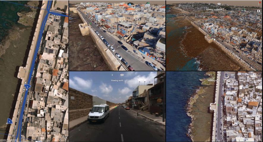
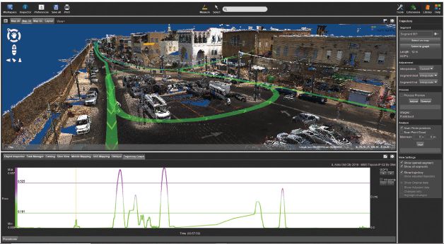
Digital twins allow cities to import and organize all available 3D data (top) as well as measure and extract 3D data based on any 3D LiDAR or DSM point cloud from aerial, outdoor or indoor mapping projects (bottom).
Creating Digital Context
Digital context is the existing environmental conditions of an infrastructure asset, geospatially referencing imagery and other data to an engineering-ready, 3D representation of reality. Creating digital context, however, doesn’t have to be a colossal task.
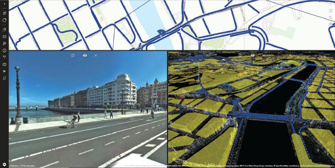
Aerial imaging—often combined with ground photography or mobile mapping—provides accurate reality models that serve as the basis for digital twins. Techniques such as drone capture, cloud processing and scalable reality-modeling solutions make it possible. Many cities already have a 3D city model, either in a proprietary GIS format or available as an open CityGML format. These models can be used as a starting point for the digital context.
Digital twins are a federated view on many different data sources in different silos. Combining reality meshes and semantic data sources such as CityGML provides rich, realistic digital twins that serve a broad variety of use cases. Reusing existing data is one of the most-important points in maintaining digital twins. Many organizations have invested in massive LiDAR and point-cloud datasets, which often are underutilized due to their huge volume.
“Advancing the 3D mapping paradigm has always been at the heart of Orbit GT’s activities,” says Peter Bonne, the former CEO of Orbit GT. “In adding to Bentley’s digital cities offerings, we will jointly broaden the solutions portfolio and provide unprecedented possibilities for collaboration among platforms.”
As a surveying and photogrammetry firm that evolved to focus on elite, large-scale, municipal data management, Orbit GT is possibly more in tune with this organizing spatial paradigm than any group of people. When it comes to federating—bringing together and presenting—large and discrete datasets in different formats, the simple x, y and z coordinate really does work.
From Static Deliverables to Dynamic Visibility
In many types of urban spaces, 4D digital context is important to digital twins because it enables asset owners to improve inspection and maintenance, planning, and resilience modeling.
To have real-time maintenance and inspection, you need continuous updates. The convergence of reality modeling, GIS, mapping, building information modeling (BIM), geotechnical data, mixed reality (XR) and Internet of Things (IoT) data feeds enables an immersive and holistic view of infrastructure assets. Because digital twins incorporate different types of data-repositories—including engineering data, operational data and data from mainstream information systems—users can bridge physical and virtual worlds. Digital twins become a virtual replica of the physical system, but the two are connected through data flows.
This focus on space meshes with Bentley’s experience with designing and collecting space in the built world. But we’ve been surprised—along with the rest of the industry—by the incredible explosion of spatial data enabled by cloud storage and processing as well as data-collection methods such as laser scanning and photo capture. One of Bentley’s users, for example, had 24 million images in one dataset. Point-cloud data files measured in terabytes are no longer remarkable. Just the scale of datasets is a serious challenge to any firm trying to improve cities.
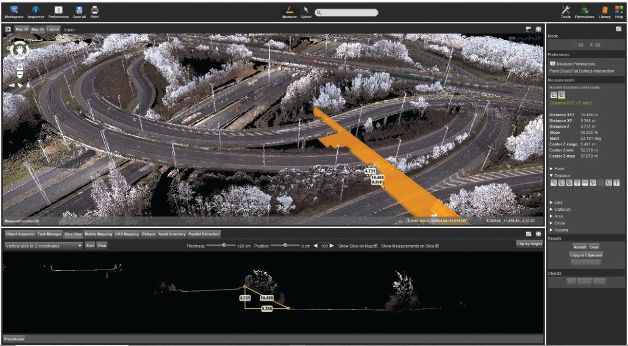
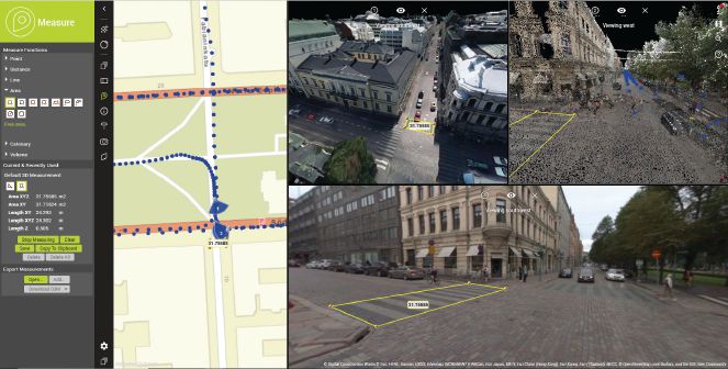
Specialized software allows users to enhance and correct 3D mapping data for positional accuracy (top) as well as analyze mapping data and create reports (bottom).
This substantial technical challenge also is an opportunity, potentially expanding the capabilities of digital twins and making them very useful. Digital twins of cities should be exact, continuously updated, 4D models of actual places that can be used for real-time decision-making on a huge scale, including efficient traffic, drone and public-transportation management. This is digital mobility.
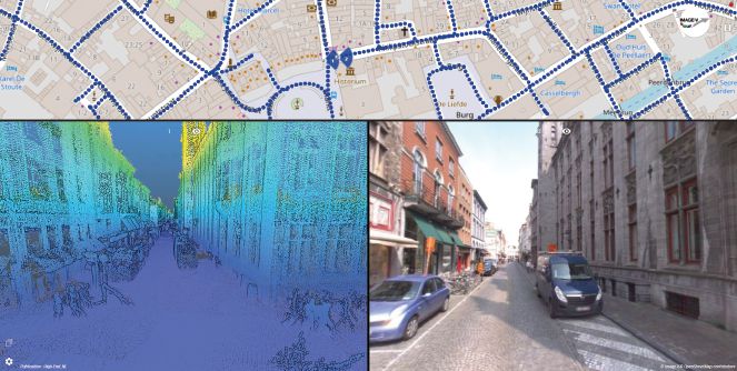
The key, however, is managing data. Many state and municipal agencies now manage huge, map-based datasets that include 360-degree images, terabytes and soon petabytes of point-cloud data, aerial LiDAR results, and mass reality-captured data from drones, mobile mapping cars and planes.
Digital twins now should be viewed as a federated view of many different data sources in different silos. Combining these large and detailed reality meshes, along with various semantic data sources in big databases, provides a rich and realistic model that serves a broad variety of use cases. Reusing existing data is one of the most important points in maintaining digital twins. Therefore, making data and space work together in a changing 3D field emerges as the dominant challenge for municipal management in the 21st century.
Consider adding the creation, visualization, integration and support of all 3D-captured reality data—coming from a variety of different capture systems and processes—to enrich your digital twin environment. Bonne puts it simply: “We are able to handle a huge amount of data, and make it available to non-technical people and useful in day-to-day workflows. We want to make the complex simple to access.”
You get the creation, visualization, integration and support of all 3D-captured reality data coming from a variety of different capture systems or processes to present your digital twin. Based on the available data (e.g., street-view images, aerial LiDAR point clouds, ContextCapture reality meshes, aerial oblique imagery, etc.), you can present a single, synchronized view that’s accessible via a web browser or desktop, adding 3D and 4D context to your digital twin.
This available data can be used to analyze, verify, measure, map and report on the environment. Based on accurate and precise LiDAR data, meshes or imagery data, users can measure, map and register attributes. Even newly created or constructed data can be added and used for communication or verification within the organization, and then shared with all necessary stakeholders.
Working from home is challenging enough without having to deal with the confusion and headaches that data silos can bring. Using a single, highly visual repository for all data—such as a digital twin—makes it easier to communicate plans for urban environments. Anyone involved in mapping and planning cities can use this as they begin to create their own digital twin, giving them the platform to implement real and necessary change in a constantly evolving world.

Lomme Devriendt
Lomme Devriendt is senior manager, business development, 3D mapping, Bentley Systems; email: [email protected]. Teresa Elliott is senior director, marketing, digital twins, Bentley Systems; email: [email protected].
Video: New Roundabout Under Construction at McIver and Old Florence Roads in Darlington County

Bridge Replacement at Amsterdam Centraal Station

June Issue 2026
.jpg?width=225)