
Virtual Surveyor Introduces Curb & Gutter Mapping in New Version of Drone Surveying Software
AARSCHOT, Belgium – Virtual Surveyor has introduced Curb & Gutter mapping functionality in Version 7.6 of its popular drone surveying software. The new capability enables surveyors to create a lightweight CAD model of curbs and gutters along the edges of streets and parking lots from standard orthophotos and elevation models captured by unmanned aerial vehicles (UAVs), or drones.
“Accurately mapping the height of curbs and geometry of gutters is critical for modeling the flow of water away from streets and other pavement surfaces into drains and dewatering infrastructure,” said Tom Op ‘t Eyndt, Virtual Surveyor CEO. “The new capability maps the existing curb and gutter configuration as a baseline for planning reconstruction or repairs of streets and sidewalks.”
Virtual Surveyor is a powerful surveying software that bridges the gap between drone photogrammetric processing applications and engineering design packages. The software generates an interactive onscreen environment with drone orthophotos/DSMs and/or LiDAR point clouds where the user can compare multiple drone surveys in a matter of seconds.
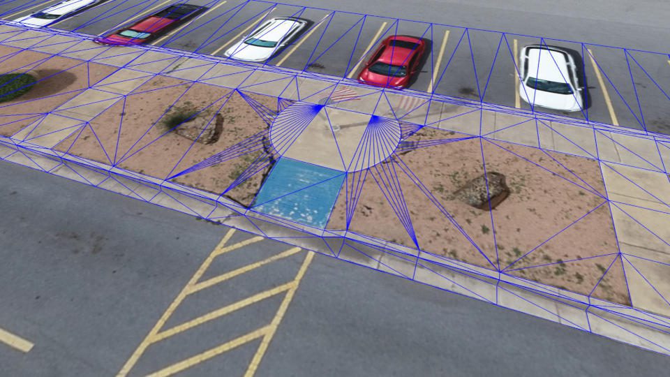
The challenge of mapping curbs in 3D from drone data is that the sharp curb edges are not captured well with drone photogrammetry. Virtual Surveyor now allows the surveyor to input curb height measurements taken in the field as offsets starting from the back of the curb. The software can then extrapolate the top and bottom values along entire lengths of the curb and gutter feature. The software will even extrapolate under overhanging objects, such as parked cars, and map the curb arc geometry around curves at street corners.
“Mapping curbs and gutters is an important surveying task that ensures that engineers start from the good baseline when designing safe road infrastructure,” said Op ‘t Eyndt.
Virtual Surveyor 7.6 contains several other enhancements that will facilitate surveying with drone data:
Circles and Rectangles – Manhole covers, planting beds and other circular or rectangular features can easily be outlined and mapped.
Interpolate Z – When the user selects the Start and End Points of vertices, the software interpolates elevation of vertices in between.
Dynamic User Experience – The software automatically changes the Input Settings shown to the user onscreen depending on the functions be performed at any given time.
Orthophoto Control – With one click, the user can turn all orthophoto layers on or off to gain a better view of contour edges and elevation changes.
The Curb & Gutter functionality is included in the Virtual Surveyor Ridge and Peak editions. Current subscribers to Virtual Surveyor will see their software being updated to Version 7.6 automatically. To start a free 14-day trial of Virtual Surveyor and to view details of the three pricing plans, visit www.virtual-surveyor.com.
Watch the new video: https://youtu.be/8BEKcYrSnhc
About Virtual Surveyor
Virtual Surveyor software enables professional surveyors to generate accurate topographic end products from drone imagery five times faster than traditional field work. Now used in 68 countries, Virtual Surveyor allows surveyors to topographic information from drone data in very short timeframes. In a typical application, the suite takes the orthophotos and digital surface models (DSM) extracted from UAV imagery with photogrammetric software like Pix4D, Metashape or DJI Terra and generates an interactive virtual environment onscreen where surveyors can select the survey points and breaklines that define topography. Standard topographic outputs from the Virtual Surveyor software are Surfaces or TINs (Triangular Irregular Network), Contours, Line Surveys and Cut-and-Fill Maps. As such, Virtual Surveyor bridges the gap between UAV photogrammetric processing software and engineering design packages.
