
CivilGEO Releases GeoHECRAS Version 3.0
Wisconsin, July 07, 2020 – CivilGEO, a leading provider of civil engineering software, has released a new version of the GeoHECRAS software. GeoHECRAS Version 3.0 utilizes an improved and easier to operate FlexNet software licensing technology from Flexera Software. This latest release provides key new features, updates, and bug fixes.
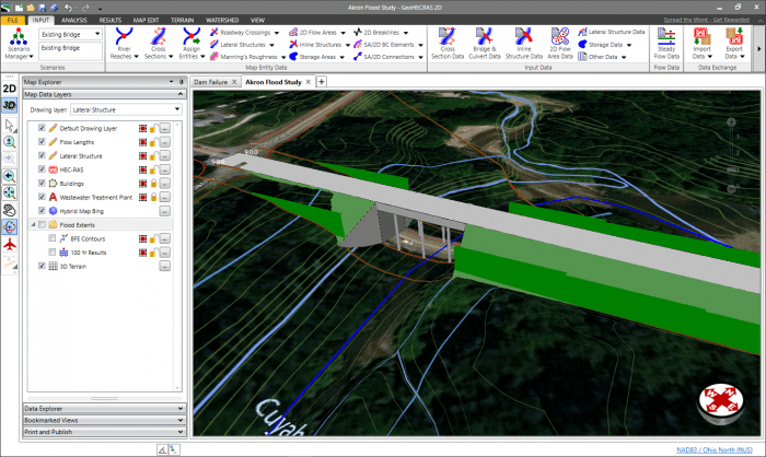
GeoHECRAS is an AutoCAD, Bentley MicroStation and ESRI ArcGIS compatible interactive 2D/3D graphical user interface data wrapper to U.S. Army Corps of Engineer’s HEC-RAS software. GeoHECRAS greatly speeds up HEC-RAS model creation and produces modeling scenarios that are more accurate and ultimately more useful to engineers.
The GeoHECRAS software rapidly constructs HEC-RAS models as it pulls data from a variety of sources. The software computes water surface profiles for steady and unsteady flow conditions, analyzes and designs bridge and culvert roadway crossings, generates floodplain and flood hazard maps, performs river and stream restorations and realignments, computes flood inundation maps for possible dam and levee failures, and much more.
Release highlights include:
- FlexNet software licensing technology from Flexera Software
- Draw 2D Mesh Face Command
- Stamp Multiple Command
- 2D Flow Training Structures
- Elevation Profile Command
- Google View Commands
- Layer Properties dialog boxes – Transformation Panel
- Multiple HEC-RAS Versions Supported
- 2D Floodplain Encroachments Command
- Improved Cross Section Geometry Extraction
Chris Maeder, Engineering Director at CivilGEO, said, “CivilGEO continues to develop GeoHECRAS to keep pace with the growing demands of the civil engineering community. As a company, we are responsive to our clients’ needs and very proactive in our approach to software design and implementation.”
CivilGEO develops advanced engineering and environmental modeling software for civil engineers worldwide. Consulting engineering organizations, public utilities, government agencies, and educational universities rely on CivilGEO’s software to engineer, design, and build the world’s infrastructure.
The GeoHECRAS Version 3.0 is now available for download.
About CivilGEO, Inc.:
CivilGEO, Inc. is a privately held company headquartered in Middleton, WI, and has multiple offices in Canada, South America, Europe, Asia Pacific Region. It is a leading provider of civil engineering software designed to meet the requirements of civil engineering consulting firms and government agencies worldwide.
