In November 2019, Informed Infrastructure Editorial Director Todd Danielson interviewed Esri President Jack Dangermond at the Autodesk University (AU) Conference in Las Vegas.
The full interview video (above) also can be viewed at bit.ly/2VTPr4q, but we wanted to include some excerpts in this issue.
Danielson: Tell me about the partnership between Esri and Autodesk.
Dangermond: Several years ago, Autodesk executives and myself got together, and we thought we should really merge, connect our technologies. This was largely driven by people who wanted to work at the data level across our respective technologies: GIS and BIM. So we’ve been working at it at the engineering level, not just interconnecting our data, but also interconnecting our tools so our respective tools can read each other’s data.
And this is transforming the whole AEC engineering, designing, building workflow because it’s providing, for the first time, direct data services from all the geographic data in the world into these workflows of building the next world or building the future.
Danielson: So when you come to this event [AU], who are you here to talk to and for what specific purpose?
Dangermond: A lot of my customers are here. They’re the large engineering firms, which is one of the largest-growing segments of my business, actually. It’s growing over 30 percent this year, because engineering firms—small and big—are saying, “I want to get some of that stuff and bring it into my engineering practice to look at things more holistically.” So that’s exciting to me. I will also meet some of the heads of a lot of the big companies. Also to meet with the Autodesk people to interconnect and make sure our technologies are working together.
Danielson: So what are your main motivations or feelings about this partnership of GIS and AEC?
Dangermond: Esri’s philosophy—and this is now our 50th year—is to build great software tools that help our users do their work better. One of my great friends, Scott Morehouse, taught me that phrase. And it really is a powerful vision that we have our eyes focused on what users need and want, and then build really great tools. Not just tools that work, but are transformational.
We take about a third of our revenue, and it goes back into “R & D” [Research & Development], and it keeps advancing the tools.
So this integration with the workflows in the AEC marketplace is fascinating to me, because it really is making a lot of geographic data relevant—not just for science or record keeping or understanding—but for creating the future.
All the engineers of the world, all the architects of the world, are desperately trying to do their job better. This integration is not simply a technology thing. It’s really a bigger contextual thing of evolving the planet in such a way that it considers all the things that we’re screwing up now. Biodiversity considers greater efficiency, so there’s less climate change. It considers making cities more livable.
We’re not only building tools for sector productivity, but also being able to integrate and look at the whole. For me, that’s what every engineer, every architect, every designer should aspire to do. Because at this particular moment in the history of the planet, the arrows in many ways are going up. We’re living in a more prosperous world. All of us are more prosperous, wealthier, less starvation, all those sorts of things.
But at the same time, the natural world arrows are not so good. Biodiversity’s dropping rapidly, and the climate change, I need not speak.
My big vision is that we can build integrated solutions through empowering companies and engineers around the world to do their job better, to make those arrows go in the other direction so we have what I like to call “sustainable prosperity.” That’s the great challenge for today’s engineers.
Danielson: So engineers and users better understand how this partnership might improve the tools, could you cite some specific examples of work and how the two tools may help each other?
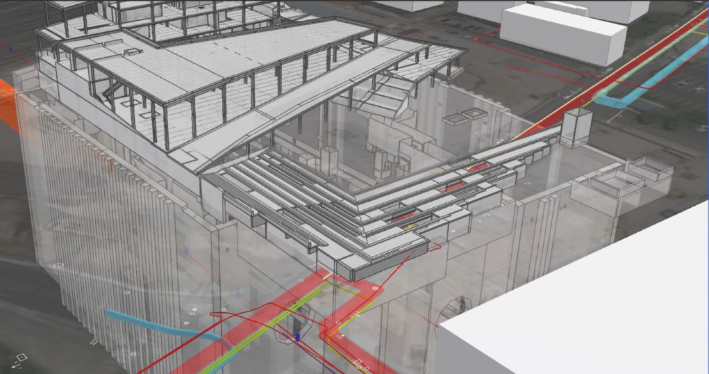
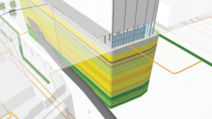
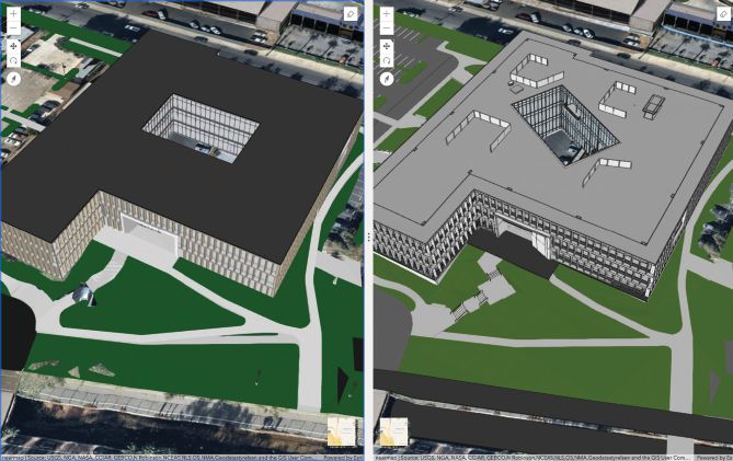
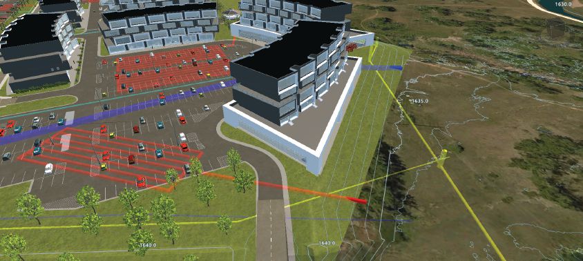
Dangermond: Users are showing me all the time. In New York, they’re taking buildings built in BIM and putting [the BIM layer] on top of geographic data to evaluate the consequences on the environment, but also to bring in social factors into the designing of a building and also the other built environment of other buildings around it, so they can visualize it, do viewsheds, and understand traffic impacts as a result of a building submission in context.
In the UK, one of our customers is working with a bunch of firms that are to design the next generation of railroad networks across the UK. And they’ve taken all the geographic data for all of the UK: terrain files, the 3D building, GIS databases, the LIDAR data, the point clouds, the context capture information. They put it all together with BIM, and you could fly around the UK and see the whole planned next-generation rail network and zoom into the rooms in the subway stations. This excites me because that may not just be about being more responsible environmentally or socially. It’s also the idea that, for the first time, I can see the whole thing as an integrated system.
Moreover, I can see that not through some fancy expensive workstation; I can see it on the web through a browser. Millions of people can view and interact with that and touch it. This is the power of GIS.
Danielson: Suppose I have a design firm and I make a building model. I’d love to incorporate the surrounding terrain and other utilities that are around, so how do I go ahead and get that data and add that into the model I’ve created?
Dangermond: Autodesk has engineered their product lines—like Revit, AutoCAD and InfraWorks—so their tools can actually read our native data services as if it’s native data that was designed and built by Autodesk tools. So they buy a $500 subscription a year to something called ArcGIS Online, the Esri geospatial cloud environment. This geospatial cloud has about 8 million users—maybe 7,000 new users every day—and those users share their information, but not all of it. Some of it they keep private in the cloud, but they can share it publicly.
So if I’m designing a building, why don’t I just bring in the soil map, the vegetation map, the slope map, the flood map? Overlay those like plastic overlays, except do it in an analytic environment and then design around it so I minimize environmental impact or avoid hazards or take advantage of a site. Then that’s particularly relevant for larger landscapes. So I’m doing that either within Autodesk tools, or they can do it within Esri tools as well.
Danielson: So they can access a lot of other information without having to fly their own drones or collect their own soil samples; access the tools that are already out there to make better models for themselves.
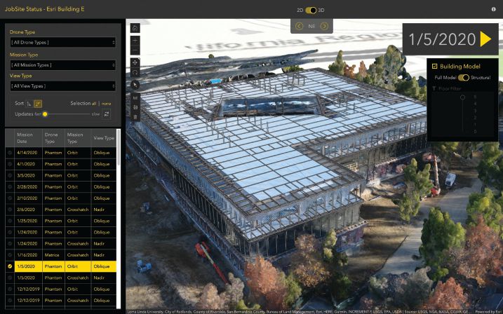
Dangermond: And they can also use that cloud to store their data. So if they fly a drone environment, they can upload their imagery into my cloud environments from their drone, and it’s managed there, and then they can read it into their design tools. So it’s an integrated environment for virtually any kind of imagery, any kind of CAD data: the Revit files, the IoT. So many of our users have living maps. They bring in IoT, like where the traffic is or what the temperature registers are in a city or what the pollution levels are. And those are real-time services that they register inside Esri’s cloud.
Oftentimes people will use our desktop tools, ArcGIS Pro, and they’ll build a beautiful map and they’ll build a beautiful 3D visualization, and they right click it and send it over into our cloud, and it automatically turns it into a service you can look at in a browser or on your device using web services and beautiful graphics in multiple ways.
So would you imagine that your data that you would create—expensive data to collect or author or models—could be right-clicked and sent over to a server and beamed out for free access by anybody in a browser? $400 or $500 a year? No. I mean, it’s like a miracle. So that product line is really growing very rapidly. We have desktop tools, ArcGIS Pro. We have server technology, and then we have this cloud environment—we make over a billion maps a day in that cloud environment. And it just keeps growing.
Danielson: So speaking of platform, I’m guessing it’s probably also popular for public presentations, for clients or public meetings.
Dangermond: Yes.
Danielson: Simple and cheap, right?
Dangermond: They’re simple and cheap, and some of the firms here that I’ve been talking with, they are taking their projects, and they build 3D scenes, and then they put them out through a browser to their customer. So the customer can look at the status of their project, whether it’s a first architectural version, second, third generation of an urban design, for example. They can mark it up; they can sketch even though they’re 5,000 miles away. There’s this idea of global collaboration by using cloud integration of the data matched up with other types of data. So it’s a very empowering capability.
Danielson: One of the first references to Smart Cities I ever heard was through Esri. At this event [AU], there is something called ArcGIS AEC Collections. Can you tell me a bit about what that is and how that can be used to help develop Smart Cities?
Dangermond: IBM started about 10 years ago with the idea of a smarter world, a smarter planet. And that was really a great marketing coup, and everybody expected IBM to come in and have smarter cities, smarter utilities and so on. That didn’t actually get realized. But the term they had and the vision they had was really correct, that you could do analytics, you could do real-time IoT integration, you could use visualization tools like GIS to make a city smarter.
The term “smart” is used in the real-time environment quite a bit. And the idea of real-time digital twins or it’s also being used in the data science world, like we can do the analytics that would really help us understand. So that’s the definition of “smart”: it’s real-time and analytics and connected.
My own interpretation is all of that and geographically integrated. Meaning all the data from different parts of the departments all can be served together into a dynamically integrated real-time digital twin. So you have a living city, and all action and activities are inter-relatable using location as a common key for bringing it all together. An aspirational goal is to help our customers make their cities—those who are urban customers—smarter through this idea of real-time integrated, smarter analytics.
With respect to the Autodesk collection and the AEC collection, that’s really bringing that environment alive and empowering it. These are the very same tools I’ve been talking about, both on Autodesk and Esri sides, and we ourselves are making offers available to customers that want to do this or packaging of the different combinations of technology that helps them with training of the technologies most of them already own as well as just a vision for how they could wire these things together.
Danielson: With cities, when they have multiple utilities, transportation networks, they’re all separate; but they’re all brought together by the location they have in the city.
Dangermond: You said it.
Danielson: I now want to talk about the people behind it all. How can the different groups—AEC people, the GIS experts—learn from each other so that they can create better models, do better work and have better projects?
Dangermond: They are getting interconnected by the web, but that’s not enough. Interconnecting services with common registries like ArcGIS Online or what we call the ArcGIS Portal are showing up in different organizations, and that’s interconnecting people. But I have a lot of belief in face-to-face meetings and interaction with people, because that’s really where trust starts, and collaboration really operates at the speed of trust. So I think humanness—willing to share, willing to collaborate on the great challenges that we’re facing as a global society—is essential.
But then there’s another factor, which is leadership. Yesterday I was speaking to the U.S. Army Corps of Engineers, and they have great leadership there. The general that runs it really gets GIS, and he’s organizing and transforming his organization along those lines. But leadership at the top is not enough. I think of leadership up and down, and you need technical leadership, you need volunteerism, the willingness to participate, the willingness and desire and the values to be able to collaborate and work together. And you say, “Well, how the hell is that going to happen? Everybody’s kind of selfish, and they look after themselves and so on.”
Look, they’re great challenges that you and I are facing. Demand it. It’s going to take every bit of our best science and our best engineering. It’s going to take all of our best creative design thinking, and it’s also going to create this idea of humanness collaborating if we’re
going to turn this around.
Todd Danielson
Todd Danielson has been in trade technology media for more than 20 years, now the editorial director for V1 Media and all of its publications: Informed Infrastructure, Earth Imaging Journal, Sensors & Systems and Asian Surveying & Mapping.
Video: New Roundabout Under Construction at McIver and Old Florence Roads in Darlington County

Bridge Replacement at Amsterdam Centraal Station

June Issue 2026
.jpg?width=225)