
AGTEK Development Company introduces major upgrade to mobile apps
(Livermore, California, USA) – AGTEK Development Company, part of Hexagon, announced today the release of a major upgrade to SmartPlan, SmartDirt and SmartTrack mobile apps to bridge the gap between the construction site and the office.
AGTEK has moved the traditional construction and earthmoving plan set into the 21st century, putting the plans into the palm of users’ hands no matter where they are in the world. Simply geo-referencing traditional 2D plans and supplementing them with rich 3D data gives users a clear picture of where they are on site and what work is left to finish the job. Without having to go back to the site office or truck, users can now drill drown into construction details. Outdated plans become a thing of the past, and wet and windy days are no longer a barrier to staying on top of what needs to be done.
AGTEK’s SmartPlan, SmartDirt and SmartTrack apps run on Apple or Android devices and use the built-in GPS, camera, compass and maps to show where the user is on-site and document site conditions.
All apps are now available for download on Google Play and Apple stores.
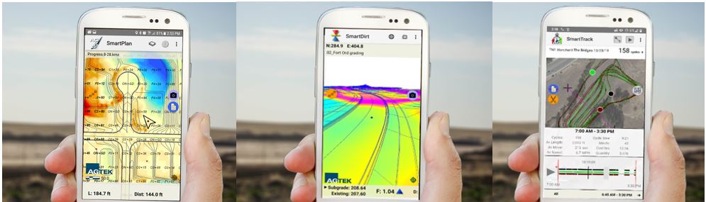
SmartPlan
Users can walk any site with a cut-fill grid map, plan set and takeoff quantities mapped into a smartphone or tablet. Without stakes, SmartPlan guides the user to find the locations of grading limits, balance regions, pad corners, slope toes, daylight lines and other plan features, and shows position on the cut-fill grid map along with PDF plan details. SmartPlan can record and measure tracks as the user drives or measures areas and lengths to document completed work.
SmartDirt
A 3D model of any dirt job can now fit in a pocket along with the plan sheets and an aerial image from the last UAV / drone flight. SmartDirt provides fast answers to keep the job moving. How much cut’s in these streets? How much fill to flatten these pads? How far to the lowest pad? What’s this berm supposed to look like? Where’s this daylight line? How long is this haul?
SmartDirt shows cut-fill and elevation wherever the user is standing, based on the takeoff, latest progress survey, or the GPS model guiding the machines. SmartDirt communicates grade and inspects models with 3D visualizations that move with the user across the site.
SmartTrack
A pocket tool for managing production in the field, SmartTrack mobile app displays real time equipment tracks from simple mobile sensors, on a geo-referenced cut-fill grid map, street network maps, satellite images, drone/UAV orthomosaics or PDF plan sheet. The app also provides foreman or project managers with a current measure of load counts, cycle lengths, cycle times, moving time, stopped time and location of all of the tracked equipment.
AGTEK Development Company – Dirt.Simple.Solutions.
AGTEK, part of Hexagon, provides Dirt Simple Solutions for the construction industry to accurately takeoff and estimate construction quantities, model efficient construction processes and measure progress throughout the construction life cycle.
Hexagon is a global leader in sensors, software and autonomous solutions. Hexagon (Nasdaq Stockholm: HEXA B) has approximately 21,000 employees in 50 countries and net sales of approximately 3.9bn EUR. Learn more at hexagon.com and follow us @HexagonAB.
